History of the Atlantic Cable & Undersea Communications
from the first submarine cable of 1850 to the worldwide fiber optic network
1971 TRANSCAN (Trans-Canary) Cable
by Bill Glover
|
History of the Atlantic Cable & Undersea Communications |
|
1971 TRANSCAN (Trans-Canary) Cable |
|
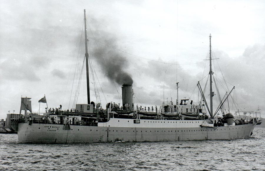
TRANSCAN (Trans Canary) OVERVIEW Prior to the laying of this cable, only Tenerife was connected to Spain by a coaxial telephone cable, PENCAN 1, laid in 1965. In 1971 CTNE contracted STC to manufacture and lay a cable between Las Palmas, Gran Canaria - Peurto del Rosario, Feurteventura and Arrecife, Lanzarote. The cable was laid in two sections of 143 nm and 44 nm, with 19 and 6 repeaters respectively, by CS John W. Mackay, chartered by STC for the laying and also the route survey. The cable provided 480 4kHz circuits. PENCAN 2 was also laid in 1971 with the terminus at Las Palmas, thus providing a link for the three islands to Spain. A link to Tenerife was laid in the following year. The same ship carried out the survey and laying.
TRANSCAN SUBMARINE CABLE PROJECT REPORT ON LAND AND SHORE END SURVEYS AT Prepared by: Standard Telephones and Cables Limited,
1. SUMMARY AND CONCLUSIONS The aims of the survey were to establish suitable submarine cable landing points on Gran Canaria, Fuerteventura and Lanzarote islands for the TRANSCAN cable project, to check the suitability of the proposed land cable routes from the beaches to the terminal buildings and to assess the existing or planned terminal station space and facilities. The STC land survey party originally arrived at Las Palmas to commence the survey on Tuesday 17th February and then continued on to the other islands, returning to Las Palmas on Thursday, 26th February for further survey activities until 1st March. The party returned to Las Palmas on 4th March, having conducted additional surveys at Tenerife in the interim period, in order to co-ordinate the activities of the cable ship John W. Mackay which was to carry out the deep sea survey campaign. As a result of the land and shore end surveys the following landing sites are recommended for the respective islands:
An alternative beach was selected on Gran Canaria in case a landing at the San Cristobal beach becomes inadvisable due to port extensions although this possibility appears remote. The alternative is: Gran Canaria Las Canteras Lat. 28° 07' 8" Long. 15 0 26' 6" It was established that the land routes from all these beaches would be ducted. The survey programme was conducted in close liaison with CTNE engineers from Madrid and Las Palmas. DIARY OF EVENTS
Tuesday 17th February 1970 Party flew to Las Palmas, Gran Canaria, and met Sr. Lucas and Sr. Perez Suarez Wednesday 18th February 1970 Discussion held in local, CTNE offices with Sr. Yurrita and Sr. Bretones. A local diving firm was consulted about their facilities of use to survey team and the proposed beaches. Terminal building then viewed, followed by visit to possible sites just south of Las Palmas. Thursday 19th February 1970 Owing to continuing unsatisfactory weather conditions party visited CTNE main offices to discuss continuation of survey work on another island. Decided to commence with land survey at Arrecife on Lanzarote and proceed with small boat work there as soon as weather suitable. Remainder of day spent viewing land routes and duct chambers. Drum trailer also inspected and measured. J.J.W.E. inspected the cables at Las Canteras beach out to the reef by skin diving. Friday 20th February 1970 Party (L. B., E. L., G. P. S., J.J.W.E., J.E.H.) flew to Arrecife, and arranged to meet the local Administration Delegate, Sr. Gonzales, the following day. Saturday 21st February 1970 Discussed the proposed work with Sr. Gonzales and then viewed suitable landing sites to the south of the port and arranged, for hire of small boat. The coastline to north of port and the site for the new exchange and some existing ducting and chambers were inspected in the afternoon together with the proposed new route through the town. Sunday 22nd February 1970 Small boat work carried out by Sr. Lucas, Sr. Infiesta, J.J.W.E. and J.E.H. Monday 23rd February 1970 Beach measurements made by STC, and land route measurements made by CTNE Tuesday 24th February 1970 Party flew to Puerto del Rosario, Fuerteventura. Possible landing sites and the existing radio link terminal building viewed. The proposed land route was also inspected. Wednesday 25th February 1970 Small boat work carried out in morning, and land route measured in afternoon. Thursday 26th February 1970 Party flew to Las Palmas, Gran Canaria. The visibility in the water at the beaches checked and boat hire arranged Friday 27th February 1970 Small boat work performed off Las Canteras beach and San Cristobal. Saturday 28th February 1970 The possible future Maspalomas landing area inspected by J.J.W.E. and. J.E.H. Sunday 1st March 1970 Survey party left Las Palmas en route to Tenerife. Wednesday 4th March 1970 J.J.W.E. and J.E.H. returned to Las Palmas. Thursday 5th March 1970 Reef off Las Canteras beach inspected by J.J.W.E. using dinghy. Friday 6th March 1970 Agents of CS John W. Mackay stated that she was due at 18.00 the following day. Saturday 7th March 1970 Ship's agents revised arrival time to 9.00 on Monday 9 th. Arrival of CTNE engineer Sr. A. Zafra for Transcan sea survey. Sunday 8th March 1970 CS John W. Mackay sighted off Las Canteras beach at about 13.00 by STC. Arrival at 9.00 the following day confirmed by agents. Monday 9th, March 1970 Ship arrived Las Palmas 09.00. CTNE engineer joined and STC party briefed as to Tenerife, Gran Canaria, Fuerteventura and Lanzarote landing sites. Capt. Harper and M.J. Hedges shown the landing sites at San Cristobal and Las Canteras. 4. LANDING SITES 4.1 Las Palmas, Gran Canaria 4.1.1. La Laja Lat. 28° 03' 29"N Long. 15° 25' 7"E) Advantages (1) Shortens sea route to Fuerteventura. (2) Land terminal approximately 8 km along partly existing duct route (as far as San Cristobal), duct route to be completed in any case to new satellite station (after completion of road works for autopista) (3) Anchoring ground probably good sand as for main anchorage off Las Palmas. (4) Clear of ship anchorage area. Disadvantages (1) Exposed to prevailing winds. (2) Subject to along shore currents setting to S. (3) Wave conditions reported bad for small boats or divers throughout the year cable will need pipe protection. (4) Fuel pipe to airport may exist? (5) Good deal of bay rocky with limiting rock reef to N. Cable ship exposed to rocky lee shore. (6) Considerable road work will take place in are immediately adjacent to landing site (could shift road line?). 4.1.2. San Cristobal Beach Lat. 28° 04' 54" Long 15° 24' 54" Recommended Site (Just to N of Castillo de San Cristobal immediately in front of new hospital). Advantages (1) Short land route 5.4 km from terminal station at Alta Vista. (2) Good anchorage ground with sand similar to main Las Palmas anchorage area. (3) Just clear of anchorage area, which is limited line E from the Cathedral, clearance about . (4) Existing ducts with access under autopista large water tunnel (existing ducts landward of autopista). (5) Adequate shore end working space, on land along 1 of 3 lanes of autopista or on rather narrow rough strip at path edge (some services in the way). (6) No future road works or building likely. (7) No restrictions on angle of cable approach from sea apart from short castle reef to S. (8) Hospital behind beach is excellent land mark. Disadvantages (1) Exposed to prevailing wind. (2) Proximity to anchorage area. But Port Captain informed CTNE anchorage S of line to E of Cathedral does not take place and they no such plans for the future). (3) Cable will need protection from wave action steep stony beach by means of pipes.
4.1.3. Las Canteras Lat. 28° 07' 48" Long. 15° 26' 39" Advantages (1) Shelter from prevailing wind. (2) Short land route 3.76 km from Alta Vista, Ducts existing (but some extra channels needed). (3) Sandy gradual beach. (4) Plenty of room for cable handling, anchorage, etc. (5) Clear of anchorage area. (6) Anchoring ground probably sand. Disadvantages (1) Exposed to swell. (2) Line of approach limited by fringing reefs. (3) Several cables already exist in the area, these can be avoided at the beach but may limit ship further to sea. (4) Certain amount industrial drainage in area fish factories, and from power station. 4.1.4. Other Sites West facing, apart from Las Canteras all other sites rocky and unsuitable. East facing, sites to S of La Laja all not possible before autopista construction and blasting along only road. Sites between La Laja and San Cristobal, rocky, exposed or small boat anchorages. Sites to N of San Cristobal within anchorage area or area of new harbour mole construction South coast, although sandy and sheltered from prevailing winds, too great a distance from terminal. Maspalomas visited and found to have extensive sheltered sandy beaches, satellite station close by, also microwave link to centre of island.. 4.1.5. Land Route Majority of manholes stated to be CTNE Type B (small), 68 cm entrance, etc. a complete list of types manhole numbers, centre to centre distances, with route map was promised by CTNE once the route to San Cristobal and Las Canteras was fixed. Ducts standard 10 cm round asbestos cement. Several manholes were viewed along the Alta Vista to San Cristobal route, one only found flooded with clear water near sea on autopista, no sign of contamination although water was flowing out of one of the ducts. Some evidence of grit at mouths of ducts here and in other manholes. CTNE stated they always wadded through all the ducts before pulling cable. No evidence of oil and other contamination was seen, and CTNE claim no troubles experienced and apart from a possible pipe line to the airport no underground oil lines near to the cable route. For approximately 1.25 kms from the hospital back towards the town at a distance of 2 metres from duct there is a 6 kV 50 Hz power cable, which is the hospital power supply. It was reported that there was a local radio station 1.2 to 1.3 MHz frequency. Frequency (believed 1.22 MHz) and power would be checked by CTNE and STC informed. No electric trains or trams existed in the area. The lowest number of ducts available on the route to San Cristobal was 2, which is so for approximately half the route. On the route to Las Canteras only 2 ducts were available and new ducting would be installed to allow spare capacity. (N.B. if both Transcan and the Pencan II extension are landed at Las Palmas, 1 transmission cable will go to San Cristobal, and two earth cables and one transmission cable will go to Las Canteras. If only the Transcan system is installed, then both transmission and earth cables should go to San Cristobal). CTNE stated that the new ducting available within 7 months of a decision on the route being made on the completion of the survey. A new road bridge at a road intersection the new road along the barranco would involve rerouting the cable later, but the extra length would be negligible. 4.1.6 Terminal Building (Alta Vista) The building is relatively new (6 years old) with considerable spare space still available, A drawing was obtained of the transmission room in which adequate space is available for new equipment (on first floor). Height of floor is 4½ metres. The equipment for the microwave link to Tenerife in the same room. The cable will run on head. racks from a. wall on the NE side and down usual vertical channel. The cable chamber ample space and spare rack facilities and runs into manhole under the pavement. It should be noted radii occupied by the existing cables is much less than permissible for submarine cables. This could be adapted without trouble. The existing power room and battery room the same level as the duct chamber. In the power room space existed for two more generators with approximate maximum of 4‑5 metres. It was stated there was a further power room available below with no equipment. The battery room was largely occupied by the batteries.. 4.1.7 Cable Drums It was noted in the CTNE central that the standard CTNE drum trailer had limiting dimensions of 2.4 metres diameter and width 1.3 metres.
4.2 Arrecife (Lanzarote) 4.2.1. Playa. del Cable Lat. 28° 57' 12" Long. 13° 34' 29" Recommended Site Advantages (1) Short land route, approximately 2 nm along existing roads, including 0.25 nm over fields from beach to road. (2) Good beach with ample clear working space tractors, pits, etc. (3) Cable ship anchorage ground good sand with no obstructions. Swell not normally severe on this side of island, although winds strong at times. (4) Well clear of port and town development. (5) Beach sand, but rock might be exposed due to storms (use of iron pipes essential), extremes of bay rocky but centre and seaward all sand. (6) Old telegraph cable landed here for many years believed without fault. Disadvantages (1) Might be used as occasional anchorage by fishing boat, but old cable site marked on maps. (2) Abandoned telegraphic cable near to planned route. 4.2.2. Beach to S of Playa del Cable (Bufadero) Lat. 28° 56' 40" Long. 13° 35' 10" Advantages (1) Wider beach and approaches. Disadvantages (1) Approach from sea shallower and more gradual. (2) Longer land route approx. 0.75 nm more. 4.2.3. Other Beaches None suitable except more to the South much further from the terminal. All beaches to N of Arrecife rocky and exposed. 4.2.4. Land Route All new ducting needed along roads with fairly clear edges. Only point of difficulty at football ground and rubbish dump due to steep bank. Some road widening planned, cable route must be outside this. CTNE preparing full act of drawings of land route ready by mid March 1970. Power cable noted running parallel to route approx.100 ft to N, 3 phase overhead line. 4.2.5. Terminal Building Not yet built, plot of land selected. Original plans for completion in 1971, will aim to have ready end. of 1970. Will also be the new local exchange building.
4.3 Puerto del Rosario (Fuerteventura) 4.3.1 Playa Blanca Lat. 28° 38' 45" Long. 13° 51' 50" (Next to Bikini Club) Recommended site Advantages (1) Very wide sandy beach sheltered from very large swells. (2) Good sandy anchorage ground off shore but rot very sheltered from prevailing wind. (3) Clear of port and town area. (4) Short land, route approximately 2½ km along 2 existing road with one small barranco to cross. (5) Adequate shore working area. (but short run for tractor) (6) Old telegraph cable selected site, believed with good history. Disadvantages (1) Occasional use by small ship for anchoring principally on S side of bay during SW gales, estimate of number of times a year varies down minimum of two. (2) Old telegraph cable in area, precise position unknown. 4.3.2. Playa Roza del Viejo Lat. 28° 30' 33" Long. 13° 50' 32" Advantages (1) Sandy bay below water level. (2) Clear of town and port. (3) Short land route 2½ km maximum along rough roads. (4) Adequate working area for tractor, etc. Disadvantages (1) Rocky foreshore, careful piping and cement bagging necessary, difficult in view of exposure to waves. (2) Exposed to weather and waves. (3) Ship anchored with rocky lee shore. 4.3.3 Las Lajas Lat. 28° 32' 25" Long. 13° 50' 09" Advantages (1) Wide sandy beach, sheltered from heavy waves. (2) Clear of town and port. (3) Adequate working area for tractor, etc. Disadvantages (1) Long and difficult land route crossing many barrancos (6 km). (2) Long shallow approach from sea. (3) Ship anchored with rocky lee shore. 4.3.4 Other Sites All other sites in area not suitable as rocky or exposed. Other sandy bays exist well to south of terminal building. 4.3.5. Land Route All new ducts needed, no problems expected. Oil pipeline parallel with route but not buried and on opposite side of road. 4.3.6. Terminal Building Just adequate space exists in present terminal building 1st floor transmission room, but CTNE prefer to use new extension about to be built onto side of building. Same aims on dates as at Arrecife.
TRANSCAN SUBMARINE CABLE PROJECT REPORT ON DEEP-SEA SURVEY MADE BY
Prepared by: Standard Telephones and Cables Limited, INDEX
1. SUMMARY AND CONCLUSIONS The aim of the survey was to establish a satisfactory submarine telephone cable route between the beach sites selected for the Transcan project at Las Palmas (Gran Canaria), Puerto del Rosario (Fuerteventura) and Arrecife (Lanzarote). The vessel used for the survey was the CS John W. Mackay owned and operated by Commercial Cable Company (Marine) Ltd., London. The personnel involved in the sea survey were:-
The survey team embarked at Las Palmas on 10th March and returned there on 14th March 1970 having surveyed the complete projected route plus a possible alternative route which entails landing at Las Canteras beach to the north of Las Palmas on Gran Canaria Island in case the preferred landing at San Cristobal to the south of Las Palmas has to be abandoned because of port extensions, etc. A satisfactory route has been established for the projected submarine telephone cable. The recommended route is basically direct but stays well to the south and east around Fuerteventura in order to give adequate clearance from the irregular profile of the island's submarine slopes and also to allow sufficient spacing from existing telegraph cables so that any repair operations which may be necessary in the future will not be impeded by these 'out of service' cables. 3. NARRATIVE This survey was carried out on behalf of Standard Telephones and Cables Limited in CS John W. Mackay. The ship arrived at Las Palmas from Majorca on March 9th and sailed at 08.00 hours on the following day having embarked the CTNE representative. The ship approached to 10 fathom line off San Cristobal beach and commenced sounding run towards Puerto del Rosario. A development survey was conducted to the south of Fuerteventura, in order to determine extent of underwater ridge. Continued sounding run up to 0.6 nm off Playa Blanca, south of Rosario Island approaches found to be steep but smooth. Ship returned along route taking temperature measurements and bottom samples. Sounding run made to investigate possibility of cutting across the route off the south eastern tip of the island but found to be unsuitable due to underwater ridge. Commenced survey run towards Arrecife during the evening of 11th March. A smooth sea bed profile was obtained except for one small peak. A sounding box was made confirming that this peak was not part of a major underwater feature. Ship approached to 0.8 nm off Playa del Cable. Two sounding runs off the beach showed that island approaches were steep but smooth. Commenced return sounding run towards Las Palmas and arrived at San Cristobal at early morning on March 13 th. Began survey of possible alternative route landing at Las Canteras to the north of Las Palmas instead of San Cristobal. Detailed sounding patterns were conducted to establish extent of underwater ridge off north eastern corner of Gran Canaria and also to select the most favourable cable route between Gran Canaria and Fuerteventura islands where the sea bed profile is comparatively rough compared with shorter cable route into San Cristobal. A further sounding grid was carried out at intersection of original and alternative routes to determine extent of an underwater peak. This showed that a more southerly route into San Cristobal than the original should have a smoother profile and this was confirmed by the ship making a sounding run along this indicated route. 4. FAULT HISTORIES OF EXISTING CABLES Cable and Wireless Ltd., Italcable and the Spanish Telegraph authorities have been contacted for information regarding repairs carried out on existing telegraph cables in this area. However, except for four repairs off Las Canteras due to corrosion and chafe no information was obtained on any repairs around Fuerteventura or Lanzarote which indicates that this is an area with a low incidence of cable damage. 5. SURVEY Initially, information was gathered from both British and US sources and all available soundings were plotted on standard 1:250,000 scale Admiralty plotting sheets. Contoured overlays were then prepared and from these the original route for survey was selected. Temperature information was obtained from the Washington Data Centre, USA. The CS John W. Mackay was equipped for the survey with a Raytheon 193 Precision Depth Recorder. On board the ship was the latest ITT navigation system type No.5001 and this was used in conjunction with radar to ensure that the highest possible navigational control was achieved. During the survey it was discovered that up to 1 nm error exists on the marine charts for this area between the relative position of Fuerteventura and Lanzarote. The recommended cable quantities reflect this anomaly by the addition of 1 nm of lightweight cable in the northern link. From a study of the initial information available it was apparent that the main objective of the survey should be to determine the exact extent of the islands' underwater features and once clear of these the surrounding sea bed was smooth. The findings of the survey substantiated these original indications and the survey programme was conducted on this basis with the outer limits of the southerly and easterly underwater features of Fuerteventura being established. The direct route between Puerto del Rosario and Arrecife was found to be suitable and other than for two of parallel runs 1 nm east and west of the proposed route to confirm the uniformity of the sea bed no further soundings were necessary. For the alternative route it was necessary to investigate the relatively irregular "saddle" between Gran Canaria and Fuerteventura. Three parallel runs were made along the complete north/south part of the route and all showed very similar features. Finally the extent of the underwater ridge off the north east tip of Gran Canaria was determined by a very comprehensive sounding grid in order that the shortest possible route around this ridge could be established in case the Las Canteras landing is used for this project. 6. FINDINGS AND RECOMMENDATIONS The results of the survey show that a more southerly route is preferable to that which was initially predicted out from San Cristobal and around Fuerteventura. The final recommended route is a modification of the shortest feasible route as established by the survey to allow for suitable spacing from existing telegraph cables to facilitate repair operations if and when required. At all beaches the cable route reaches deep water quickly hence reducing the hazard from trawler activity and reducing the total quantity of armoured cable. Generally on the San Cristobal - Puerto del Rosario - Arrecife recommended route the deep water profile is smooth and appears to be heavily sedimented. Any southerly deviation from the route would not be expected to affect the profile, however, any deviations which bring the route nearer to land could result in the cable being layed over some major sea bed irregularity. It is strongly recommended that an additional 1 nm of lightweight cable be included in the cable quantities to compensate for the navigational anomaly encountered during the survey between the respective positions of Fuerteventura and Lanzarote islands. If the alternative route is selected, i.e. with the Gran Canaria landing at Las Canteras the route length is increased by 30 nm approx. 7. SUMMARY OF RECOMMENDED CABLE TYPES AND LENGTHS FOR PRIME ROUTE The following table lengths recommended for indicates the co-axial cable types and lengths recommended for the prime route, i.e. Gran Canaria landing at San Cristobal. The amount of slack has been estimated using an allowance of 5% for lightweight cable. Type A cable is armoured with 0.300 inch (7.6 mm) diameter wires and Type B with 0.192 inch (4.9 mm) diameter wires.
It can be seen from the attached schematic diagram of the proposed system (Attachment 7) that the Type AB screened cable is a 0.620"/0.200" coaxial structure and it is necessary to introduce nominal 0.015 nm lengths of Type A 0.620"/0200" cable between the screened cable and the adjacent repeaters in order to permit the construction of cable terminations. All other armoured coaxial cables will be of 0.990"/0.329" construction. On the sea bed profile diagram (Attachment 2)it is indicated that transition from armoured to lightweight cable should occur at 400 fathoms. A nominal 1.00 nm length of Type B cable has been introduced adjacent to this transition point to facilitate the laying of the cable from a mechanical point of view since it is not advisable to lay heavy armoured cable such as Type A in deep water with no intermediate cable to the lightweight. At the Arrecife approaches the length of Type B cable has been extended so that the armour transition between Type A and Type B coincides with R6. At all shallow water approaches the Type A cable extends out to at least the 100 fathom depth mark in. accordance with normal cable practice. SUMMARY OF CABLE TYPES (PRIME ROUTE)
SUMMARY OF RECOMMENDED SPARE CABLE (PRIME ROUTE) Based on the above system cable quantities the following spare cable lengths are recommended:
The 0.620"/0.200" spare cable lengths permit a complete replacement of any shore end if required. The Type A 0.990"/0.329" spare cable quantity includes two 0.2 nm lengths for use as buffers at the end of each lay to compensate for minor navigational errors and the necessary ship manoeuvres approaching the final splice positions. The lightweight spare cable is sufficient for one complete cable section. In addition to the above spare cable quantities the following terminated spare tails are recommended:- 6 x 15 fathoms 0.990" L/W tails 2 x 15 fathoms 0.990" Type A armoured tails 1 x 15 fathoms 0.620" Type A armoured tail 8. SUMMARY OF RECOMMENDED CABLE TYPES AND LENGTHS FOR ALTERNATIVE ROUTE The following cable indicates the co-axial cable types and lengths recommended for the alternative route, i.e. Gran Canaria landing at Las Canteras. The amount of slack has been estimated using an allowance of 5% for lightweight cable.
This shows an overall increase of 31.54 nm of cable compared to the prime route cable quantities and as can be seen from the sea bed profile (Attachment 2) the route is more irregular than that encountered when landing at San Cristobal. Spare cable quantities if this alternative was finally selected would be similar to those recommended for the preferred route as per Para. 7. 9. SEA EARTH CABLE QUANTITIES The recommended sea earth cable lengths are as follows:-
It is recommended that one complete replacement of the sea earth system is available if required, i.e. 1.00 nm Type A 4 core cable plus 1 earth plate, as spare. Attachment No. 2A PROPOSED ROUTE DEPTH PROFILE
ATTACHMENT No. 2B ALTERNATIVE ROUTE DEPTH PROFILE
ATTACHMENT No. 3 LIST OF ROUTE CO-ORDINATES (PRIME ROUTE)
ATTACHMENT No. 4 LIST OF ROUTE CO-ORDINATES (ALTERNATIVE ROUTE)
ATTACHMENT No 5 DEPTH-TEMPERATURE PROFILE ATTACHMENT No 6 SUMMARY OF OCEANOGRAPHIC STATIONS
ATTACHMENT No 7 PROPOSED SCHEMATIC LINE DIAGRAM
|
|||||||||||||||||||||||||||||||||||||||||||||||||||||||||||||||||||||||||||||||||||||||||||||||||||||||||||||||||||||||||||||||||||||||||||||||||||||||||||||||||||||||||||||||||||||||||||||||||||||||||||||||||||||||||||||||||||||||||||||||||||||||||||||||||||||||||||||||||||||||||||||||||||||||||||||||||||||||||||||||||||||||||||||||||||||||||||||||||||||||||||||||||||||||||||||||||||||||||||||||||||||||||||||||||||||||||||||||||||||||||||||||||||||||||||||||||||||||||||||||||||||||||||||||||||||||||||||||||||||||||||||||||||||||||||||||||||||||||||||||||||||||||||||||||||||||||||||||||||||||||||||||||||||||||||||||||||||||||||||||||||||||||||||||||||||||||||||||||||||||||||||||||||||||||||||||||||||||||||||||||||||||||||||||||||||
|
Last revised: 8 November, 2011 |
|