Introduction: Broadsides or broadsheets are single sheets of paper, often of a large format and generally printed on only one side so that they can be used as posters. However, Maurice Rickards, in the Encyclopedia of Ephemera, notes that: “The words ‘broadside’ and ‘broadsheet’ are by many regarded as synonymous (‘A large printed sheet of paper’). But specialist opinion favours ‘broadside’ for a single-sided sheet and ‘broadsheet’ where both sides are printed.”
Broadsides have been used since the very beginning of printing to inform the public of news stories and other events of general interest. Many were given away; others were produced, like posters today, to be sold as souvenirs of popular events.
While broadsides are informative as well as decorative, and may have extensive text as well as illustrations, lithographs are mainly decorative. Examples of Atlantic Cable lithographs shown here include those from Sarony, Weingärtner and Kimmel & Forster.
The laying of the Atlantic Cable in 1858, and the subsequent expeditions of 1865 and 1866, gave rise to the production of many souvenir and commemorative items, and printers and publishers were quick to capitalize on these widely-reported events. Broadsides and lithographs were common in both Britain and the USA, but most of the cable images shown here originated in America.
The early Atlantic cables were laid prior to the general advent of chromolithography in the later part of the 19th century, so many of these images were printed in black and white; some were hand tinted or coloured to enhance their appeal.
Information in the caption immediately below each image is transcribed directly from the original; dimensions are given as Height x Width.
If you know of any cable broadside or lithograph not shown here, please email me: [email protected]
Note also that maps of the Atlantic cable routes were issued by several different publishers. Unless they have significant added material I have not included them here, but some may be seen in the Cable Maps section. There were also handbills and printed souvenirs for the Atlantic cables, some of which are included on this page.
|
| 1856 |
Chart Shewing the Intended Telegraphic Communication between Newfoundland & Ireland...
Day & Son, London |
| |
|
This coloured lithograph of the proposed track of the first Atlantic Cable is titled:
Chart Shewing the Intended Telegraphic Communication between Newfoundland and Ireland, Tracks of Steamers between Europe & America and the Ice Fields in the North Atlantic Ocean. 1856.
It is marked below the image:
Cyrus W. Field, New York.
London. Dec. 4th 1856. Compiled, Engraved & Published by Day & Son, Lithographers to the Queen. 6 Gate Street, Lincolns Inn Fields.
In 1865 Day & Son published William Russell’s book on the Great Eastern Atlantic cable expedition of that year. The firm was the most prolific lithographer of the Victorian era and also produced a number of the other British prints shown on this page.
As well as the route of the Atlantic cable, the chart shows existing and proposed submarine cables together with the land lines in North America and the British Isles which would connect the cable to the existing telegraph network. The cable connecting Newfoundland to Nova Scotia had been completed in July 1856, and two cables between Ireland and the British mainland are also shown.
At the bottom of the chart is a cross section diagram of the bed of the Atlantic Ocean, taken from Captain O.H. Berryman’s soundings made using the USS Arctic. Above that are drawings showing the cross section and length of the cable already laid between Newfoundland and Nova Scotia, and the cable to be used for the main Atlantic run.
The elaborate title is at the top center left, and to its right is a list of the officers of the New York, Newfoundland & London Telegraph Company.
The lithograph was advertised for sale at a price of two shillings and sixpence, available through booksellers or directly from the London offices of the Atlantic Telegraph Company, which suggests that the company may have commissioned Day & Son(s) to print the chart:
The chart was reproduced in Charles Bright’s 1898 book “Submarine Telegraphs, Their History, Construction and Working.”
The accuracy of Berryman’s sea bed profiles (as shown on the chart above) were subsequently called into question by Matthew Fontaine Maury, Superintendent of the US Naval Observatory and Hydrographic Office. In 1854 Maury had been Cyrus Field’s authority (via Samuel Morse) for the “Telegraphic Plateau” running across the bottom of the Atlantic Ocean between Ireland and Newfoundland.
Berryman’s 1856 soundings did not really support this, and the following events are described in this 2012 article from Hydro International by Albert E. Theberge Jr.: The Myth of the Telegraphic Plateau:
After a three-week cruise, Berryman arrived in Ireland on 23 August. During his time there, he incurred Maury’s wrath by handing over a version of the seafloor profile to the telegraph company and the British press which subsequently published it. On the return trip Berryman made a few additional soundings.
Whether Maury was more concerned with assuring the scientific integrity of the results or felt that he had been upstaged by Berryman is unclear. Either way, upon the return of the USS Arctic he attacked Berryman, the results of the survey, and the methods used, in the Explanations and Sailing Directions Accompanying the Wind and Current Charts published in 1858.
In that book, Maury says:
...Lieut. Berryman constructed and submitted to the Navy Department two charts, each with a profile of the bottom of the Atlantic between Trinity Bay, Newfoundland, and Valentia, Ireland. Neither of these charts agrees with the log; and they differ widely from each other. They give soundings that are not in the log; and the log gives soundings that are not on them. Copies of these charts got into the hands of the Telegraph Company without the knowledge of the Navy Department, or of this ofiice. Not suspecting their accuracy, the company had them lithographed and circulated broadcast.
The depths of the ocean as there given by this company* were received by the world as correct, and published extensively both in this country and Europe.
Thus error has gone forth. It is desirable that truth should overtake it; and hence the necessity of fully exposing it here, and at once.
* Vide chart entitled “Profile of the bottom of the Atlantic between Valencia Bay, Ireland, and St. John”s, Newfoundland, as sounded by the United States steamer *lsq
Arctic,’ Captain O.H. Berryman,” on chart entitled “Chart showing the intended telegraphic communication between Newfoundland and Ireland, track of steamers between Europe and America, and the ice fields in the North Atlantic Ocean, 1856. New York, Newfoundland and London Telegraph Company...”
Maury goes on to compare Berryman’s 1856 results with those of the 1857 survey using HMS Cyclops by the British naval officer Lieutenant Dayman, using differences between the two surveys as examples of Berryman’s errors.
According to the Hydro International article linked above, later surveys vindicated Berryman and the Telegraphic Plateau eventually fell into disrepute, but by then both he and Maury had died. |
|
|
| 1857 |
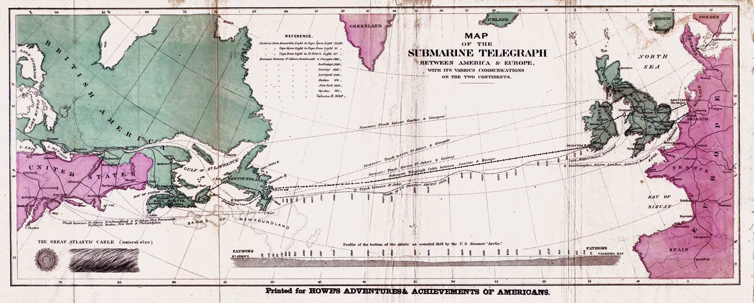
Map of the Submarine Telegraph between America & Europe, with its Various Communications on the Two Continents
Korff Brothers, New York |
| |

Map of the Submarine Telegraph
between America & Europe,
with its Various Communications
on the Two Continents
Overall size 6¾" x 18"
(cropped image shown here)
Sold by Charles Magnus, Lith. 12 Frankfort St. N.Y.
Entered according to Act of Congress in 1857 by Korff Brothers in the Clerk’s Office of the District Court of the U.S. of the Southern District of New York.
Image courtesy of Norman B. Leventhal Map Center
at the Boston Public Library |
First edition:
This map, registered in 1857 in New York by Korff Brothers, shows the proposed track of the first Atlantic Cable, together with the onward land and cable connections at each end. It uses an odd projection, with the coastline of North America running almost due east-west. At the bottom are drawings of a section and length of the 1857 cable, and a profile of the bottom of the Atlantic Ocean as surveyed by USS Arctic in 1856. See the note on this in the entry for "Chart Shewing the Intended Telegraphic Communication between Newfoundland & Ireland" immediately above.
The inset in the "British America" part of the map showing the "Harbour of St John’s, Newfoundland" was of course not relevant to the Atlantic cable, which was landed in 1858 in Trinity Bay, about fifty miles to the west of St John’s. This inset was removed from the map in the 1858 second edition (see below). Both editions also have a number of variations in the overprinted text, as described.
Note that any color irregularities in the images here are a result of Photoshop restoration of faded and discolored copies of each map.
The map above lists as the seller Charles Magnus, a prolific New York lithographer. In 1858 Magnus produced his own map of Trinity Bay, as well as an elaborate broadside in three variations.
Another copy carries only the name of Korff Brothers, who were its originators and publishers. On this version the title has been moved to the blank area just below Ireland and the resulting space is filled with a Korff Brothers “With Compliments” notice.

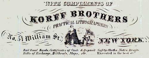
With Compliments of
Korff Brothers
Practical Lithographers
No. 54 William St. New York.
Rail Road Bonds, Certificates of Stock & Deposit, Safety Checks, Notes, Drafts, Bills of Exchange, Billheads, Maps, etc.
Executed in the best style
|
A third version of this map has yet another variation of the title text, with a different Korff Brothers logo and this additional wording at the bottom: “Sold by McKee & Stilwell, (American & Foreign Newpapers & Patent Medicines,) 89 Nassau St., (Sun Building,) N.Y.” There is also text from McKee & Stilwell on the back of the map, which indicates that it was sent out to their customers as a promotional sample.

Korff Brothers
Practical Lithographers
No. 54 William St. New York. |
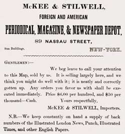 |
This notice gives an interesting insight into pricing at the time, with a wholesale cost of just six cents per map in quantities of one hundred.
McKEE & STILWELL,
FOREIGN AND AMERICAN
PERIODICAL, MARINE, & NEWSPAPER DEPOT,
89 NASSAU STREET,
Sun Buildings, NEW YORK |
GENTLEMEN:—
We beg leave to call your attention to this Map, sold by us. It is selling largely here, and we think you might do well with it; it is neatly and correctly gotten up. Any orders you favor us with shall he executed immediately. Price $6.00 per hundred, and $50 per thousand—Cash.
Yours respectfully,
McKEE & STILWELL, Importers.
N.B.—We keep constantly on hand a supply of back numbers of the Illustrated London News, Punch, Illustrated Times, and other English Papers.
|
Other copies of this edition in archives and libraries have a variety of sellers’ names, and while most Atlantic cable broadsides and maps are known today in only a handful of copies, this Korff Brothers map is relatively common because of widespread distribution of the first edition by both Korff and their private-label customers, and the use of both the first and second editions in at least two books..
Second edition:
A new version of the map, with the inset detail of the Harbour of St John’s removed, was evidently issued in 1858, when it was supplied to the New York publisher Rudd & Carleton for use in the book “The Story of the Telegraph, and a History of the Great Atlantic Cable” by Charles Briggs and Augustus Maverick.
This version of the map has “Published by Rudd & Carleton, New York, 1858” overprinted below the title, with the Korff Brothers logo in an oval towards the bottom right; the logo also appears in this form on one of the 1857 maps. The map also retains the 1857 registration notice that appears on the first edition maps.
Both editions of the map were also used as an insert in some editions of a book by Henry Howe, "Adventures and Achievements of Americans,” which has an interesting publication history of material on the first Atlantic cable.
The book was first published in 1858, and a copy of this edition at Google Books has nothing on the Atlantic cable. However, the same edition in my reference archive includes a twelve-page chapter titled "The Atlantic Telegraph." This chapter was evidently added after the first printing of the 1858 edition had already been sold, as it appears at the end of the text and is not listed in the Contents.
This copy has the map shown below inserted opposite the frontispiece of the book, with the book’s author and title overprinted at the bottom of the map as “Printed for Howe’s Adventures & Achievements of Americans.” As with some of the earlier maps, Korff Brothers removed their own name from the map, in effect “private labelling” it for their customer.
Second edition map from second printing of the 1858 first edition of Howe’s book |
A new edition of Howe’s book appeared in 1859. The twelve-page chapter published in 1858 has been removed, and a two-page article titled "The Atlantic Sub-Marine Telegraph" is listed in the Contents and appears at the end of the section on "Eminent American Inventors." The catalog entry for this edition at the New York Public Library notes that the illustrations include a map, but this has not yet been verified.
The 1860 edition has the long article (not listed in Contents), and the 1861 edition returns to the short article (not in Contents). It is not known if the Korff map was included in the 1860 or 1861 editions (although if it is, the 1860 edition with the long article seems the most likely).
There is another copy of the map (shown below) which is overprinted “Printed for Howes’ Adventures & Achievements of Americans”(note the typo of “Howes’” for “Howe’s”), and this version uses the 1857 first edition of the map. As the map is separated from the book it was published in, the date of the edition of the book cannot be established.
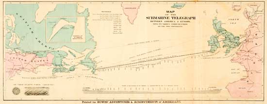
First edition map from unknown edition of Howe’s book |
in 1865 Korff Brothers published a map with an identical title, but with a different representation of the geography of the cable route and adjoining connections, and with the addition of a view of the 1865 cable.. |
|
|
| 1857 |
The Atlantic Telegraph Cable
W. Foster, London |
| |
The Atlantic Telegraph Cable
London: Published August 4th 1857, by W. Foster, 114, Fenchurch Street.
Josiah Taylor Del. Vincent Brooks Lith.
Overall size 22¾" x 37"
Image courtesy of Grosvenor Prints |
This coloured lithograph was published on August 4th 1857, by W. Foster, 114, Fenchurch Street, London. The artist was Josiah Taylor (1819-1877), and the printer was Vincent Brooks.
The ships of the cable fleet, from left to right, are the British Leopard and Agamemnon, and the American Niagara and Susquehanna, off Valentia, Ireland. August 4th 1857 was the day before the cable fleet laid the shore end at Valentia, before commencing the first attempt to lay the cable across the Atlantic to Newfoundland.
The handwritten dedication reads:
To His Excellency George M. Dallas, Envoy Extraordinary and Minister Plenipotentiary from the United States, this Print of the Vessels engaged in laying the Atlantic Telegraph Cable, is respectfully dedicated by his most obedient Servant, [...]
The print has been trimmed at the bottom and the rest of the wording is lost, but the inscription on another copy of the lithograph closes with the name of the artist, Josiah Taylor.
A similar inscription on another print closes with the name of its publisher, William Foster.
This carte de visite of Cyrus Field, by Charles D. Fredricks & Co of New York, shows Field standing next to a floor globe and holding a length of cable. On the wall behind him, at the right side of the image, is a copy of the Foster lithograph, as can be seen in the adjacent detail of the CDV.
Note: The image and description of the Atlantic Telegraph Cable lithograph appear here by kind permission of Grosvenor Prints, from whom the original is available for sale. Another copy is in the Atlantic Cable Website collection.
William Foster was a London nautical publisher. The Mercantile Marine Magazine and Nautical Record was published monthly under his imprint at the Fenchurch Street address beginning in January 1854, and continued until 1874. The March 1854 issue of the magazine had this advertisement, reproduced here for its description of the lithographs:
NEW MARINE PRINTS.
The Himalaya; Peninsular and Oriental Company’s Screw-steamer.
The Croesus; General Screw Steam Shipping Company’s Screw-steamer.
H. J. Buchan, Southampton;
W. Foster, 114, Fenchurch
Street, London.
These are tinted Lithographs of the finest Screw-steamers, forming part of the noble fleet of the two companies to which each respectively belongs. They are executed in a superior style, and deserve the consideration of all collectors of prints in the “Nautical Line,” to whose stock they will form a very elegant addition. |
Foster also published a number of other ship lithographs of a similar style.
The lithographer, Vincent Brooks, set up in business in 1848, and later bought Day & Son, publisher of William Russell’s book The Atlantic Telegraph. Josiah Taylor was a well-known marine artist and printmaker of the mid-nineteenth century.
See also John Mullaly’s note on this lithograph; Mullaly was “Historian of the Enterprise” and sailed with the cable fleet.
This and other cable-related lithographs were sought in 1892 by an advertiser in the trade newspaper The Electrician:
|
|
|
| 1858 |
Chart of the Submarine Atlantic Telegraph
W.J. Barker & R.K. Kuhns, Philadelphia |
| |
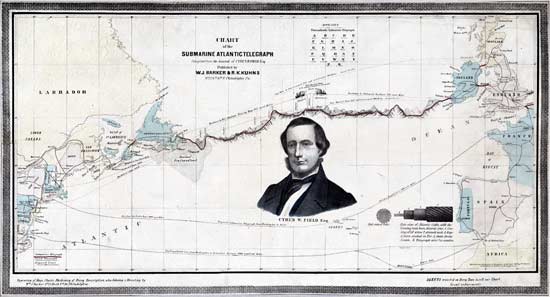
Chart of the Submarine Atlantic Telegraph
Compiled from the Journal of Cyrus W. Field Esq.
Published by W.J. Barker & R.K. Kuhns
No. 23 Nth 6th St. Philadelphia Pa.
Entered according to Act of Congress in the Year 1858 by W.J. Barker in the Eastern District of Pennsylvania
Engraving of Maps, Chars, Machinery of Every Description, also Coloring & Mounting by Wm. J. Barker No. 23 Nth 6th Str. Philadelphia.
Agents wanted in Every Town to sell our Chart
Great inducements.
Overall size 12" x 24"
Image courtesy of Library of Congress |
This lithograph is based on a map of the Atlantic between Newfoundland and Britain, with the route of the cable superimposed on a topographical drawing of the seabed; the onward cable connections from Ireland to the British mainland are also marked.
A portrait of Cyrus Field is in the center; to his right are drawings of a section and length of the Atlantic cable. The ships Niagara and Agamemnon are shown in mid-ocean, ready to make the splice in the cable, this illustration titled: “The starting Point of the Atlantic Submarine Telegraph Fleet.” A table showing the Morse alphabet is at the top of the broadside.
At the bottom of the print proposed cable routes are shown from Washington to Paris via the Azores, and Washington to Gibraltar via Madeira. These are completely fanciful. |
|
|
| 1858 |
Map of Trinity Bay, Telegraph Station of the Atlantic-Cable
Charles Magnus, New York |
| |
Charles Magnus (1826-1900) was a German-born print publisher, map dealer, bookseller and stationer working in New York City from 1850 to 1899. He issued over a thousand different lettersheets, maps, songsheets, envelopes, and separate prints. More information on Magnus, and many images of his work, may be found at the Winterthur Library website; further images may be viewed at the New York Public Library Digital Gallery.
This “Map of Trinity Bay, Telegraph Station of the Atlantic-Cable” must have been published soon after the first test messages were exchanged over the Atlantic cable on 6 August 1858, as it does not mention the official messages between Queen Victoria and President Buchanan transmitted eleven days later.
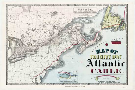
Map of Trinity Bay, Telegraph Station of the Atlantic- Cable
Published by Charles Magnus & Co., New York. 50 Cents.
Map title: Canada, Nova Scotia & New Brunswick &c.
Overall size 19¾" x 29¼" (50 x 74 cm)
Image courtesy of Library of Congress |
For this hand-colored broadside Magnus evidently took a stock map of Canada (including Newfoundland and the East Coast of the USA) and overprinted it to show details of the 1858 cable. The track of the western end of the submarine cable from Ireland to Newfoundland is marked, together with the connection via Nova Scotia and the mainland on to New York City and Washington, D.C.
The routes of the undersea cables and land lines are shown in red, with an explanatory note off the coast of Massachusetts:
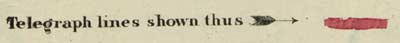
Telegraph lines shown thus |
The hand-drawn red line showing the telegraph connection from Washington, D.C., to Halifax, Nova Scotia, partially overlays hashmarked lines denoting railroad tracks on the original map. From Nova Scotia to Heart’s Content and out into the Atlantic Ocean, the red line is drawn freehand. This can be seen on the Nova Scotia detail below:
In the blank area of the Atlantic Ocean Magnus has added a multi-colored fancy title, sketches of a cross-section and length of the cable, an overall view of the route of the deep-sea portion of the cable, and a map of the Valencia cable landing. Details of these are shown below.
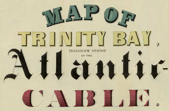
Map of
Trinity Bay,
Telegraph Station
of the
Atlantic Cable
|

Section of Cable
Cable connecting America with Europe
|

Atlantic Ocean between Latitude 47° & 52°½
Both ends of the cable landed
and signals exchanged since August 6th 1858
|

Map of the Harbor of Valencia
showing the
Atlantic Telegraph Station in Europe
|
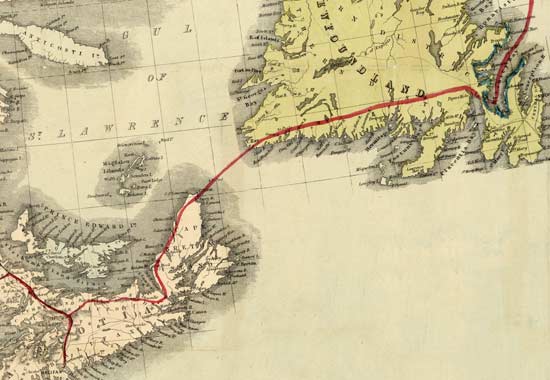
Detail of map showing connections
across Newfoundland and Nova Scotia |
This combination map and broadside may have been produced somewhat hastily by Magnus to cash in on the Atlantic Cable enthusiasm of 1858. It mentions that signals had been exchanged over the cable since August 6th, but makes no note of the official messages between Queen Victoria and President Buchanan on August 17th, so it must have been produced in advance of the first edition of his Submarine Telegraph Panorama broadsides shown in the next section.
On the original of this copy of the print the entire overprint is badly skewed, with its text running into the border of the map. To properly render the broadside I have corrected this error on the version shown here. |
|
|
| 1858 |
The Submarine Telegraph Panorama
Charles Magnus, New York |
| |
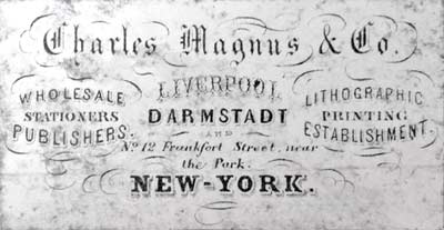
For biographical data on Charles Magnus (1826-1900), see the introduction to the previous broadside.
Three variations of “The Submarine Telegraph Panorama” are known, produced by Charles Magnus in quick succession. On 18 August 1858 he placed this classified advertisement in the New York Times; the ad also appeared in the New-York Tribune on 19 August.:
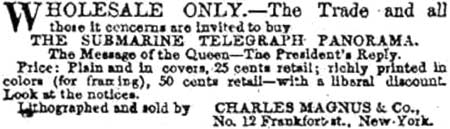 |
WHOLESALE ONLY.—The Trade and all
those it concerns are invited to buy
THE SUBMARINE TELEGRAPH PANORAMA
The Message of the Queen—The President’s Reply.
Price: plain and in covers, 25 cents, retail; richly printed in
colors (for framing), 50 cents, retail—with a liberal discount.
Look at the notices. |
| Lithographed and sold by |
CHARLES MAGNUS & Co.,
No. 12 Frankfort st., New-York. |
|
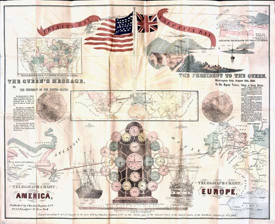
The first edition was advertised just a day after the August 17th publication of the texts of the messages exchanged by Queen Victoria and President Buchanan. The date of the second edition is not known, but the third and final edition has an added line referring to the celebrations of September 1st and 2nd and must have been issued soon after. Evidently working hard to catch the market for souvenirs of the success of the cable, Magnus offered the three different versions for sale within a span of just over two weeks.
All three are highly detailed and hand-coloured, and each includes images of the flags of the USA and Great Britain; an illustration of the landing point of the cable at Valentia Bay, Ireland; the text of the messages exchanged over the cable between the President and the Queen; maps of telegraph lines of the United States and Canada and of the Atlantic cable route with details of the onward connections at both ends; a world Time Indicator with New York as its focus; drawings of the ships Niagara and Agamemnon; a profile of the bottom of the Atlantic on the route of the cable as sounded in 1856 by the US steamer Arctic; distances from St John’s to Valentia and New York.
There are two errors on the location of the Newfoundland end of the cable as shown on all three editions. The track of the cable is correctly marked as terminating in Trinity Bay, but the caption “TRINITY BAY” actually marks Conception Bay, further to the east and not far from St John’s. Also, the length of the Atlantic part of the cable is given as “Distance between St Johns, Trinity Bay to Valentia Bay 1640 Miles,” while the location of St John’s is in fact approximately 50 miles east of Trinity Bay.
All have the maker’s name at the bottom:
Published by Charles Magnus & Co.
No. 12 Frankfort St. New-York.
and the registration notice:
Entered according to act of Congress, in the year 1858 by Charles Magnus & Co. in the clerks office of the district Court of the United States of the Southern district of New York.
As can be seen by comparing the images shown here, there are a number of significant differences between the various versions of the broadside: the flags, the maps, the messages, the globes, the typefaces, etc. Some of these changes are described in the notes on each edition.
First edition:
This version has “Telegraph Chart America & Europe” at the bottom left and different flags from the later ones. A line showing the track of the cable across the Atlantic between these two sections has been enhanced with a red overlay, and the onward connections at both ends are also marked. The track of the cable is marked “Submarine Teleg” on the left and “between America & Europe” on the right; this wording also appears on the second edition, but third edition has a variation.
The copy shown here appears to have been folded, but does not have a card cover. Another copy of this version is folded into a 5" x 3.5" card cover, on which it is titled “The Submarine Telegraph Panorama.”
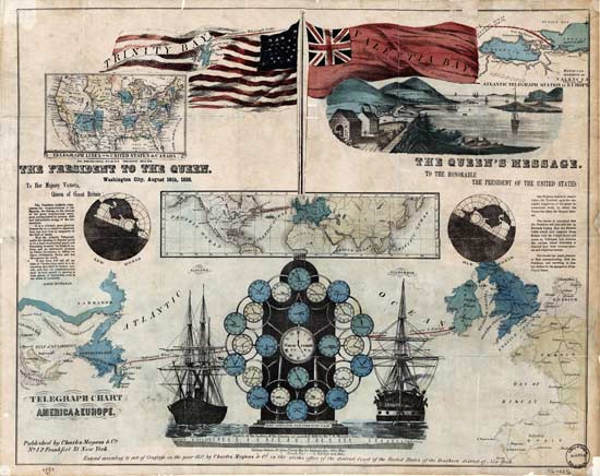
Telegraph Chart, America & Europe
Published by Charles Magnus & Co., No. 12 Frankfort St. New York.
Overall size 18½" x 23¼"
Image courtesy of Library of Congress |
Known copies of each of the first and second editions have identical card covers, one on pink card, the other on blue.
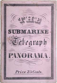
Cover of “The Submarine Telegraph Panorama”
First Edition |
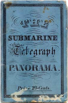
Cover of “The Submarine Telegraph Panorama” Second Edition
Image courtesy of Dibner Library,
Smithsonian Institution
Call number TK5609 .S94 1858 |
Second edition:
This copy of the broadside at the Smithsonian Institution’s Dibner Library is in a blue card cover (see above), and has many changes from the first edition. Its flags are a quite different style, and the Queen’s and President’s messages have changed sides. It is now captioned “Telegraph Chart America” at the bottom left and “Telegraph Chart Europe” at the bottom right.
The third edition (see below) is very similar to the second, but has some further variations in the typefaces and graphics.
As with the first edition, the track of the cable is marked in red on the second edition and captioned with the same wording.
Its blue card cover, shown above, is titled “The Submarine Telegraph Panorama” with “Price 25 Cents” below, but as with both folded examples of the first edition, the broadside is colored rather than plain.
The Submarine Telegraph Panorama
Published by Charles Magnus & Co., No. 12 Frankfort St. New York.
Overall size 19¾" x 24"
Folded to 5" x 3.5"
Image courtesy of Dibner Library,
Smithsonian Institution
Call number TK5609 .S94 1858 |
Third edition:
In America on Stone, page 270, Harry T. Peters describes a further variant of the broadside, shown below.
“Celebration all over the United States in Honor of Ocean Telegraphing, Sept., 1858,” large, on thin paper, tells its own story, and shows how essentially popular, timely, and ephemeral Magnus’s work was.
It celebrates the completion of the laying and opening of the cable. Here we have it all—the title at the bottom reads—“Celebration all over the United States in Honor of Ocean Telegraphing, Sept., 1858.” As can be seen, it shows maps, charts, Trinity Bay and Valentia Bay, the President’s Message to the Queen, and the Queen’s Message to the President, the ship that laid the cable, and a chart to advise what the time was everywhere—all ready to be mailed in an envelope for 25c. What more could any one ask from lithography, or any other art? Here we find one of the rare things that Currier & Ives overlooked, There was another interesting lithograph of the occasion by Kimmel & Forster, entitled “Eighth Wonder of the World,” but the Magnus one is far more interesting and records no end of detail. It is needless to add that the Queen was Victoria and the President, James Buchanan.
This version has the same flags and overall layout as the second edition, but it does not have the red enhancement on the main track across the Atlantic, and the description of the line is different from that of the first two editions, with “ELECTRIC CABLE” replacing “Submarine Teleg” on the western end of the line.
This edition also has text added in the the bottom margin mentioning the celebrations held in many cities around the USA on September 1st and 2nd, which indicates that it was a later printing made subsequent to these events, making it the final version of the three known editions.
“Celebration all over the United States in Honor of Ocean Telegraphing. Sept. 1858.”
Below this is:
“Ready to be Mailed in Envelope 25 Cents”
This copy does not appear to have been folded to fit a 5" x 3.5" card cover.
Magnus also published in 1858 a “Map of Trinity Bay, Telegraph Station of the Atlantic-Cable”, size 19¾" x 29¼" (50 x 74 cm.), according to the Library of Congress; see the previous entry in this section.
Related Magnus Lettersheets:
In 1863 Charles Magnus issued this store card, or trade token:
“C. Magnus’ National Printing Establishment. New York.”
An eagle on shield, ribbons
inscribed E Pluribus Unum.
19mm, brass |
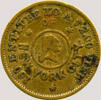
“100 Entitle To A $2.00 View
Of New York City.”
Bust of Washington
in a circle, 3 stars
Fuld-630AS-1b |
This was catalogued by the American Journal of Numismatics, Vol.I No.10, New York, February 1867. p.79, in an article titled:
“Copperheads:
A descriptive catalogue of the copper and base metallic currency issued in the several states of the United States, commencing in 1863 and ending in 1864.”
The token was effectively a two-cent piece; the reason for the production of such private currency was the hoarding of government-issued coins as a result of the economic turmoil of the Civil War. The US government soon took exception to this, made private currency illegal, and issued its own two cent piece in 1864.
While according to the inscription on the token, 100 of them could be exchanged for a $2 print of New York, it seems likely that many stayed in circulation and were never redeemed.
Charles Magnus label from back of a print of Manhattan |
|
|
|
| 1858 |
The Laying of the Cable–John and Jonathan Joining Hands
Baker & Godwin, New York |
| |
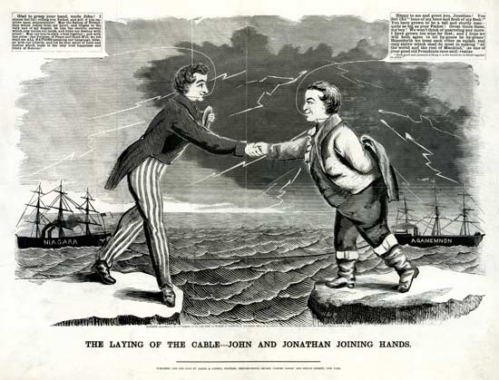
The Laying of the Cable—John and Jonathan Joining Hands
Published and for sale by Baker & Godwin, Printers,
Printing-House Square, Corner Nassau and Spruce Streets, New York.
Signed ‘W & P” in the woodcut
Entered according to Act of Congress, in the year 1858, by Baker & Godwin, in the Clerk’s Office of the District Court of the United States for the Southern District of New York.
[The Library's impression of the print was deposited for copyright on August 28, 1858.]
Overall size 17½" x 23"
Woodcut with Letterpress
Image courtesy of Library of Congress |
This somewhat fanciful broadside shows the US and British cable ships Niagara and Agamemnon on opposite sides of the Atlantic ocean, connected by the cable. Lightning bolts from the sky signify the establishment of electrical communication between Europe and North America.
Brother Jonathan of the United States and Britain’s John Bull are shaking hands across the ocean, and each man has a speech balloon:
Jonathan:
| Glad to grasp your hand, uncle John! I almost feel like calling you Father, and will if you improve upon acquaintance! May the feeling of Friendship which comes from my heart, and tingles to the very end of my fingers, be like the electric current which now unites our lands, and links our destiny with yours! May our hearts always beat together; and with one pulse–one Purpose, of Peace and Good-Will, we yet shall see ALL NATIONS speaking our language, blessed with our Liberty, and led by that spirit of Love and Justice which leads to the only true happiness and Glory of Nations! |
John:
Happy to see and greet you, Jonathan! You feel like “bone of my bone and flesh of my flesh!” You have grown to be a tall and sturdy man—quite as big as your Father! Great times these, my boy! We won’t think of quarreling any more. I have grown too wise for that and I hope we will both agree to let bygones be bygones! Henceforth we treat each other as equals, and only strive which shall do most in making “all the world and the rest of Mankind,” as one of your good old Presidents once said) realize
“How good and pleasant a thing it is for brethren to dwell together in unity.” |
In August 2021 Royal Mail issued a miniature sheet of four stamps commemorating The Electric Revolution. The image chosen to represent the Transatlantic Cable was based on this broadside.
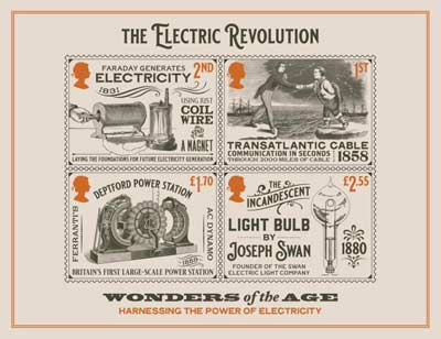
Many thanks to Roy Kettle for sending the
presentation pack of this interesting set of stamps |
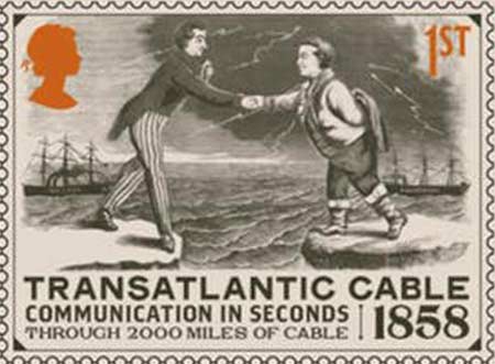
TRANSATLANTIC CABLE 1858
Communication in Seconds
Through 2000 Miles of Cable
|
More on Baker & Godwin
The New York Public Library Digital Collections has an 1865 chromolithograph of Printing-House Square published by Baker & Godwin, showing the firm’s offices in the Tribune building.
Baker & Godwin also published this handbill featuring the Atlantic Telegraph as a “Triumph of Science,” along with the the Lightning Press and the Sewing Machine:
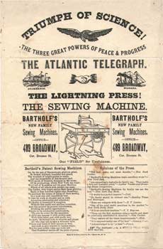
Bill Holly Archive |
It is not known if this handbill was distributed during the 1858 celebration. |
|
|
| 1858 |
The Atlantic Cable
Sarony, Major & Knapp, New York |
| |

The Atlantic Cable
Lith. of Sarony, Major & Knapp. 449 Broadway. N. York.
Entered according to act of Congress in the year 1858, by Chas. M. Connolly & Co. in the clerk’s office of the district Court of the Southern district of New York.
Overall size 11" x 14"
Image area 7.25" x 12"
|
This lithograph has a portrait of Cyrus Field at the top, watched over by cherubs. In the center, within an elaborately decorated frame, are HMS Agamemnon and USS Niagara. At the bottom, an eagle perched on flags and shields of the USA and Britain, with a length of cable below, carries in its mouth a banner “E Pluribus Unum”.
At the left is a British flag, on which is printed “Fine Chewing Tobacco”; below is a cone of cable as stored on the ships. To the right is an American flag on which is printed “Richmond Va.”; below is a telegraph signal recording instrument. Both flags are oddly rendered; the British flag has a large expanse of solid red at the bottom, and on the American flag the stripes run in the wrong direction.
Around the top of the frame are eight further flags or banners. Again. some of these do not conform to the originals, but they appear to be, in order from left to right: Russia, Sweden, not known, Holland, not known, Prussia, Sardinia, and Norway.
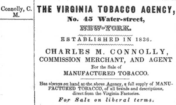
This lithograph was evidently an advertising piece for Atlantic Cable brand “Fine Chewing Tobacco”. Charles M. Connolly, who registered the artwork in 1858, was the proprietor of the Virginia Tobacco Agency, No. 45 Water Street, New York. Established in 1836, the company was a “Commission Merchant, and Agent for the Principal Tobacco Manufacturers of Virginia”.
Sheldon & Co’s Business or
Advertising
Directory, New-York 1845 |
The Valentine Archives Collection in Richmond, Virginia, has a tobacco label “Atlantic Cable Coil Twist, Richmond, Va.” [V.68.1853.75], dated “late 19th century - early 20th century”, but from other sources the Atlantic Cable tobacco brand dates to much earlier. The earliest reference so far found for Atlantic Cable tobacco appears in an auction advertisement in the Daily Alta California newspaper (San Francisco) issue of 9 July 1859:
De Ro & Eldridge, Wholesale Grocery and Merchandise Auction House. Monday July 11, 1859. 34 cases Atlantic Cable Twist Tobacco.
Another company’s advertisement appeared in the same paper’s issue of 6 January 1860:
Jas. Patrick & Co...have for sale, in store and to arrive, the following well known brands of Virginia manufactured Tobacco... Fancy Tobaccos...Atlantic Cable Twist, in foil.
James Patrick, a general goods dealer, had advertised other brands of tobacco in previous issues of the paper, but this is his first mention of Atlantic Cable brand.
[California Digital Newspaper Collection].
The tobacco was also advertised later that year in Australia, in The Argus newspaper (Melbourne) issue of 30 April 1860:
Flower, M’Donald, and Co.: Tobaccos for sale, in parcels to suit the trade: Atlantic Cable Twist, in tin foil.
|
|
|
| 1858 |
Torchlight Procession around the World
A. Weingärtner’s Lithography, New York |
| |

Torchlight Procession around the World
What
the B’hoys intended by the Atlantic Cable Celebration
September 1?
1858
Dedicated to Young America
by the Author & Publisher
A. Weingärtner, Lithographer, 87 Fulton St. New York.
Entered according to act of Congress, in the year 1858, by A. Weingärtner in the clerk’s office of the district Court of the United States of the Southern district of New York.
Overall size 14" x 18"
Image courtesy of Library of Congress
The National Maritime Museum also has a copy |
This print shows allegorical scenes related to the laying of the Atlantic telegraph cable, and head-and-shoulders portraits of Benjamin Franklin, Samuel Morse, Cyrus Field, and Captain Hudson of the USS Niagara.
Evoking volunteer fire departments, the U.S. is shown as a “fire laddie,” sending a bolt of electricity in the direction of England. Heathens of the world help lay the cable, while at the bottom of the broadside King Neptune and his mermaids seem rather bemused by the disturbance of their domain.
Further information on the image may be found at The History Project - University of California, Davis [archive page]
A number of other images by A[dam] Weingärtner are shown at the New York Public Library Digital Gallery. |
|
|
| 1858 |
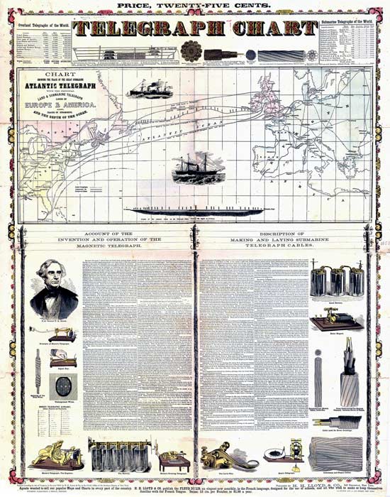
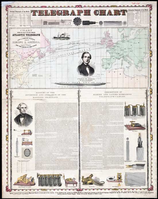
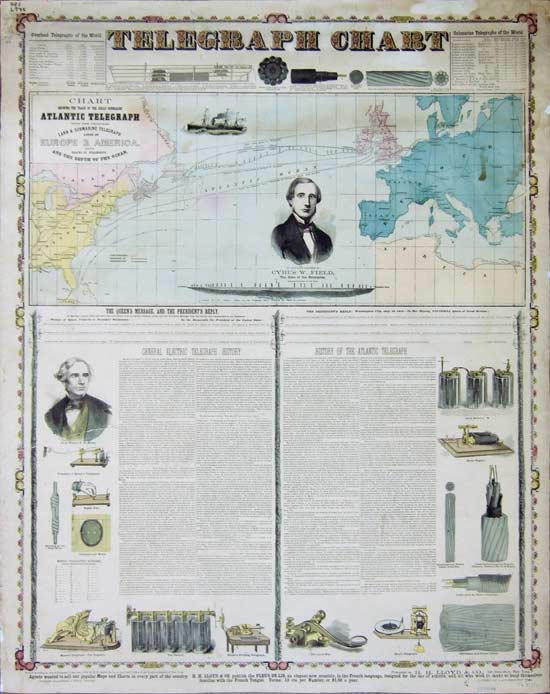
Telegraph Chart
H.H. Lloyd, New York |
| |
This broadside is known in four different versions, all of which are shown below..
The first edition has two states. The first state has an incorrect “H. Lloyd” as the registrant and is lacking additional wording at top and bottom. The second state has the corrected “H.H. Lloyd” as registrant; “Price, Twenty-Five Cents” at the top; and “Wynkoop, Hallenbeck & Thomas, Printers” at the bottom, together with promotional wording from H.H. Lloyd.
The second edition omits the price at the top and replaces the ship image in the center of the first section with a portrait of Cyrus W. Field, but is othewise identical to the first edition, second state.
The third edition has the title area for the texts on landline and submarine telegraphy re-arranged to include the Queen’s and President’s messages, but is othewise identical to the second edition.
First edition, first state:

Telegraph Chart
Published by H.H. Lloyd & Co., 348 Broadway, New York.
Entered according to Act of Congress, in the year 1858, by H. Lloyd & Co.,
in the Clerk’s Office of the Southern District of New York.
Overall size 337⁄8" x 267⁄8" |
First edition, second state:
Price, Twenty-Five Cents.
Telegraph Chart
Published by H.H. Lloyd & Co., 348 Broadway, New York.
Entered according to Act of Congress, in the year 1858, by H.H. Lloyd & Co.,
in the Clerk’s Office of the Southern District of New York.
Agents wanted to sell our popular Maps and Charts in every part of the country. H.H. Lloyd & Co. publish the Fleur de Lis, an elegant new monthly, in the French language, designed for the use of schools, and all who wish to make or keep themselves familiar with the French Tongue. Terms; 15 cts. per Number, or $1.50 a year.
Wynkoop, Hallenbeck & Thomas, Printers. 113 Fulton and 48 Ann Street, New York
Overall size 337⁄8" x 267⁄8" |
This broadside gives a capsule history of the telegraph industry up until the laying of the 1858 Atlantic cable. At the top are tables of the overland and submarine telegraphs of the world, and in between are a lateral section of the Niagara, end and side views of the Atlantic cable, and of the Gulf of St. Lawrence cable. A “Chart Showing the Track of the Great Submarine Atlantic Telegraph, with the Principal Land & Submarine Telegraph Lines of Europe & America. Also, Tracks of Steamships and the Depth of the Ocean” needs no further description, except to note that the ship images do not represent any of the vessels of the cable fleet.
Two illustrated text sections occupy the rest of the sheet: “Account of the Invention and Operation of the Magnetic Telegraph”, with images of Morse and his equipment, and a table of the Morse Telegraphic Alphabet; and a “Description of Making and Laying Submarine Telegraph Cables” with images of cables and equipment from 1851 to date.
A second variation of the broadside (below) has a portrait of Cyrus Field replacing one of the ship images in the top section, but is otherwise identical.
Second edition:
Telegraph Chart
Published by H.H. Lloyd & Co., 348 Broadway, New York.
Entered according to Act of Congress, in the year 1858, by H.H. Lloyd & Co.,
in the Clerk’s Office of the Southern District of New York.
Agents wanted... (full wording as above)
Wynkoop, Hallenbeck & Thomas, Printers. 113 Fulton and 48 Ann Street, New York
Overall size 34" x 26" (?)
Image courtesy of Norman B. Leventhal Map Center
at the Boston Public Library
Thanks also to David and Julia Bart for their image of this version of the chart |
The Connecticut State Library has a third version of the broadside. It also has the portrait of Cyrus Field, but the title area for the texts on landline and submarine telegraphy has been re-arranged to include the Queen’s and President’s messages over the 1858 cable. It seems likely that this is the third and final edition, made after the completion of the cable in August 1858.
Third edition:
Telegraph Chart
Published by H.H. Lloyd & Co., 348 Broadway, New York.
Entered according to Act of Congress, in the year 1858, by H.H. Lloyd & Co.,
in the Clerk’s Office of the Southern District of New York.
Agents wanted... (full wording as above)
Wynkoop, Hallenbeck & Thomas, Printers. 113 Fulton and 48 Ann Street, New York
Overall size 34" x 26" (?)
Image courtesy of Connecticut State Library |
H.H. Lloyd published many maps, charts, and broadsides.
Wynkoop, Hallenbeck & Thomas, Printers, participated in the celebratory parade for the successful laying of the Atlantic cable in New York on 1 September 1858. This story and woodcut appeared in the Frank Leslie’s Illustrated issue of September 25th 1858:
THE PRINTING TRUCK IN THE TELEGRAPHIC PROCESSION.
One of the principal and most attractive features in the great municipal procession on the telegraph jubilee of September 1st was the massive truck, twenty feet long by ten broad, on which Hoe’s printing presses and an old hand press were kept at work during the entire passage of the great cortege.
This truck was supplied by Messrs. Hoe to the New York Typographical Society, and was drawn by eight powerful horses. The men were from the well-known establishment of Messrs. Wynkoop, Hallenbeck & Thomas, whose printers struck off thousands of impressions of brief histories of the telegraph, Mrs. Stephens’ Ode, &c., from one of the celebrated cylinder presses, and distributed them among the multitude.
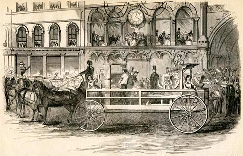
Printing Car as it Appeared at the Cable Jubilee, September 1, 1858,
with Hoe’s Presses, Being Worked by the Printers of Wynkoop,
Hallenbeck & Thomas’s Establishment |
It is not recorded which “brief history of the telegraph” was distributed from the truck, but according to the Detailed Report of the Proceedings Had in Commemoration of the Successful Laying of the Atlantic Telegraph Cable, published in 1863, “Mrs Stephens’ Ode” was to be performed at the Crystal Palace:
Mrs. Ann S. Stephens having kindly prepared a couple of odes suitable to the occasion, and the Harmonic Society having generously proffered the services of their extensive and excellent choir to perform the same at the Crystal Palace, it was proposed that the ceremonies should be varied not only by instrumental, but also by vocal music, into which should be introduced the odes of Mrs. Stephens, together with appropriate extracts from oratorios, &c., and the offer of the Harmonic Society was accepted for the performance of this part.
Mrs Stephens’ odes were “The Cable,” sung to the tune of “The Star-Spangled Banner,” and “All Hail,” to the tune of “God Save the Queen.”
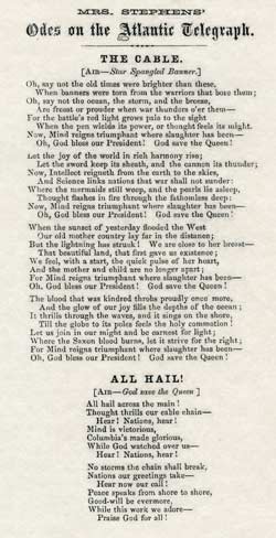
Facsimile image
courtesy of Jerry Simkin |
The Proceedings also described the printing car:
Then came an immense car, drawn by eight horses, on which were mounted three printing presses, namely, one of Messrs. R. Hoe & Co.’s single cylinder presses, a card press, and a queer old relic, in the shape of a wooden press, more than a hundred years old, with the primitive buckskin balls for inking apparatus. Printed sheets were thrown off by the respective presses on this car, as the procession moved along.
Among the printed matter worked off by the press, and scattered among the crowd, were the ode written by Mrs. Stephens, a paper entitled “The Atlantic Telegraph,” another purporting to give “A Brief History of Printing,” and the Queen’s and President’s messages, all of which were very creditable specimens of printing. The contrast between the press as it was one hundred years since and the printing press as it is now, was brought before the public eye vividly. Four pretty little girls, dressed in white, with red trimmings, helped to distribute the printed matter.
The “queer old relic” on the printing truck was a Ramage Press. The Daily Alta California newspaper (Volume 10, Number 269, 1 October 1858) had this description:
Next came an immense platform, drawn by eight horses, beautifully decorated, upon which was an old Ramage press, upwards of one hundred years old, and two of Hoe’s “latest and most modem editions,” at each of which, under the rays of a burning sun, a merry looking set of printers printed odes to the Cable...
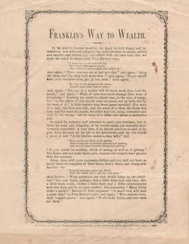
This handbill, “Franklin’s Way to Wealth,” has a tagline:
"Printed on the RAMAGE PRESS, while in procession, on the celebration of the Atlantic Cable, Sept. 1, 1858.”
Bill Holly Archive |
This humorous broadside, titled “The Ocean Invasion,” is marked at the bottom:
“Printed in the Procession, at the Celebration of the Atlantic Telegraph Cable.”
The text begins:
“At a meeting of tenants of the deep, held off Cape Breton, yesterday afternoon, reports the Boston Gazette, the Prince of Whales was chosen President, who stated the object of the meeting was to discuss the merits of the Atlantic Cable...”
After much discussion, the meeting voted:
“that the Cable be allowed to remain, and the proceedings were ordered to be published in the Gazette, to be furnished through the Cable, a battery of electric eels having volunteered their services for the occasion.”
The broadside was presumably the work of the Boston Gazette; the full text was reprinted without credit or other attribution on the front page of the 21 October 1858 issue of the Nebraska Advertiser. |
|
|
| 1858 |
The Celebration in San Francisco
Sterett & Butler, San Francisco |
| |
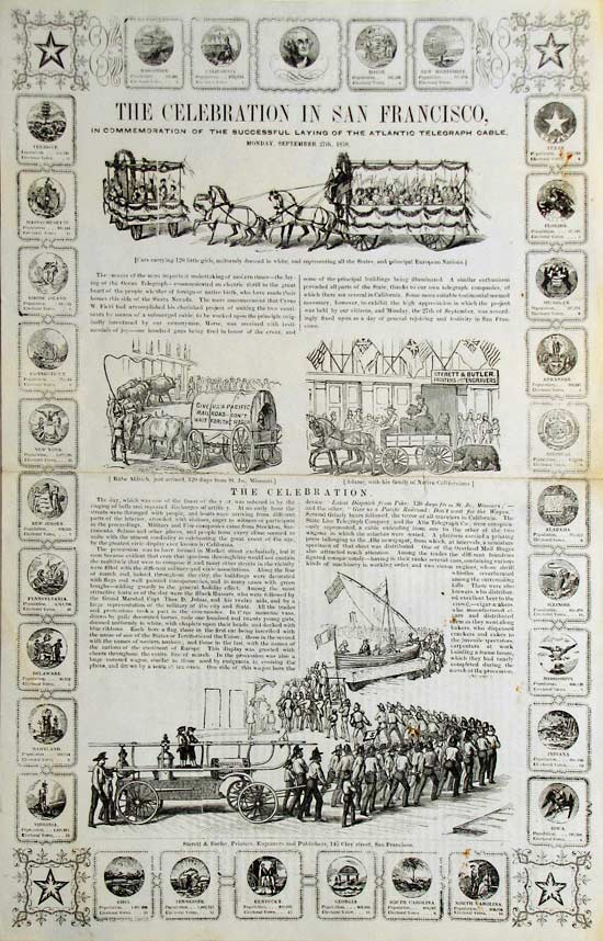
The Celebration in San Francisco
In Commemoration of the Successful Laying of the Atlantic Telegraph Cable
Monday, September 27th, 1858.
Sterett & Butler, Printer, Engravers and Publishers, 145 Clay street, San Francisco.
Overall size 16½" x 10¾" |
This wood engraving has around its periphery 35 small illustrations: four stars in the corner, thirty small seals of the States, and one unidentified portrait at the top. In the body of the sheet are several larger illustrations:
Cars carrying 120 little girls, uniformly dressed in white, and representing all the States, and principal European Nations; Rube Aldrich, just arrived, 120 days from St. Jo., Missouri; Adams with his family of Native Californians; and the men of the Knickerbocker 5 Fire Company in procession behind a float of a small boat with cable coiled on its deck.
An account in the Daily Alta California newspaper of 27 September 1858 gives details of the firemen’s programme for the evening, listing the participants and the route of the procession. The story is titled: “Atlantic Telegraph Celebration, Grand Torchlight Procession of the San Francisco Fire Department,” and noted that “The Department dismiss at the grand finale of the Fire Works”.
Here is the full text of the broadside:
The day, which was one of the finest of the year, was ushered in by the tinning of bells and repeated discharges of artillery. At an early hour the streets were thronged with people, and boats were arriving from different parts of the interior, crowded with visitors, eager to witness or participate
in the proceedings. Military and Fire Companies came from Stockton, Sacramento, Solana and other places, and people from every clime seemed to unite with the utmost cordiality in celebrating the great event of the age, by the greatest civic display ever known in California.
The procession was to have formed in Market street exclusively, but it soon became evident that even that spacious thoroughfare would not contain the multitude that were to compose it, and many other streets in the vicinity were filled with the different military and civic associations. Along the line of march. and, indeed, throughout the city, the buildings were decorated with flags and well painted transparencies, and in many cases with green boughs—adding greatly to the general holiday effect. Among the most attractive features of the day were the Black Hussars, who were followed by
the Grand Marshal, Capt. Thos. D. Johns, and his twelve aids, and by a large representation of the military of the city and State.
All the trades and professions took a part in the ceremonies. In three immense vans, drawn by gaily decorated horses, rode one hundred and twenty young girls, dressed uniformly in white, with chaplets upon their heads, and decked with blue ribbons. Each bore a flag, those in the first car being inscribed with the name of one of the States or Territories of the Union; those in the second with the names of western nations; and those in the last, with the names of the nations of the continent of Europe This display was greeted with cheers throughout the entire line of march.
In the procession was also a huge covered wagon, similar to those used by emigrants, in crossing the plains, and drawn by a team of ten oxen. One side of this wagon bore the device “Latest Dispatch from Pike: 120 days from St. Jo., Missouri;”—
and the other, “Give us a Pacific Railroad: Don’t wait for the Wagon.” Several Grizzly bears followed, the terror of all travelers in California.
The
State Line Telegraph Company, and the Alta Telegraph Co., were conspicuously represented, a cable extending from one to the other of the two
wagons in which the attaches were seated. A platform carried a printing press belonging to the Alta newspaper, from which, at intervals, a miniature
specimen of that sheet was distributed. One of the Overland Mail Stages
also attracted much attention.
Among the trades the different foundries
figured conspicuously—having in their ranks several cars, containing various
kinds of machinery in working order, and two steam engines, whose shrill
whistles reverberated among the surrounding
hills. There were also
brewers, who distributed excellent beer to the
crowd; cigar-makers,
who manufactured cigars and distributed them as they went along; bakers, who dispensed crackers and cakes to
the juvenile spectators; carpenters at work
building a frame house, which they had nearly
completed during the
march of the procession; box-makers, at their work; and a deputation of boat-builders bearing with them a handsome two-masted vessel, filled with sailors. and surrounded by an imitation sea.
The Express of Wells, Fargo, & Co., Freeman’s, and the Alta Express Co., made fine displays with their long
lines of wagons, loaded down with packages of goods and treasure boxes. A.H. Houston, street contractor, had a fine turnout of workmen with their horses and wagons, handsomely decorated. On one of the very numerous vans belonging to the trades were elevated a variety of light wagons and vehicles made by R.S. Eells; Geo. P. Kimball & Co., also had a large number of carriages; Maine and Winchester saddlery and harness.
H.C. Hayden, agent of Wheeler & Wilson’s sewing machines, turned in line with a handsome span of grey horses
and carriage, containing one of their celebrated sewing machines—horses handsomely decorated in red, white and blue; a monster wagon loaded with Napa soda, and another with a stock of Geo. Thacher’s celebrated California wines, manufactured at Los Angeles, occupied leading places; P. Whitbeck also exhibited a fine array of carriages and wagons of California manufacture; the attaches of the mint made a neat appearance, bearing with them a portion of the machinery used in the manufacture of coin and a large quantity of the precious metal, in strips and other shapes which it is made to assume preparatory to being “struck;” the Mercantile Library Association turned out 30 men, and the Society of California Pioneers, about 60 members; a quartz-crusher with eight stamps in operation, was carried by the representatives of the Pacific Foundry. D. Norcross exhibited a loom used in making fringes, and the Bricklayer’s Association a large model of the Fort.
The Odd Fellows, Free Masons, and other benevolent societies, were out in all their splendid regalia. Not the least conspicuous were the Commandery of the Knights of Malta, mounted on black horses, and attired in a sable costume of Spanish cut, with silver trimmings and plumes, and each wearing upon the back of his gloves the blood red cross of Malta. Several military and fire companies were interspersed throughout the line—the splendid engines of Knickerbocker and Tiger companies being conspicuous, the former turning out 85 men. Two little boys, attired in the costume of the old Knickerbockers, were mounted upon the engine. They constituted one of the prominent features of the day. The Sons of the Emerald Isle and the Turn Verein Club were likewise out in strong force.
The whole procession was not less than three miles in length, and occupied several hours in passing. In all its features, dress, decoration, emblems and music, it was fully equal to anything of the kind ever witnessed at the East.
The ceremonies closed with an eloquent oration by Col. E.D. Baker, a poem by a literary gentleman of the city, and a song by two thousand little children from the public schools—of whom San Francisco alone has upward of seven thousand.
In the evening the Firemen had a torch-light procession, finally forming a circle around the Plaza, where fireworks held together a large concourse of spectators until 12 o’clock at night. The city was also illuminated, and hardly an accident occurred to mar the general rejoicing.
The occasion was enthusiastically observed in Sacramento, and throughout the State, and the stock of all the telegraphic associations has gone up rapidly in consequence of the success of the ocean cable. Several companies are already engaged in the construction of lines to the Mississippi.
The streets throughout the day wore the aspect of a European city during the carnival. Crowds in holiday costume, swayed hither and thither, and the air was filled with the strains of martial music. Among the chief points of attraction during the illumination were Sargent’s popular American Exchange Hotel, on Sansome street, where the flags of all nations were displayed in profusion, and across the street a large transparency, on which America and England were represented by female figures, with the ocean intervening and the Niagara and Agamemnon approaching the two shores in the act of laying the cable: Motto, “American and England—Science, Skill, and Industry.”
The British Consulate was illuminated, and exhibited also a grand transparency, with a motto complimentary to the union of the two nations. The manner in which, during the day, the English and Americans fraternized, showed an entente cordiale superior to that heretofore existing between the English and the French. A frame maker on Montgomery street exhibited a single candle as the sole illumination for a very large window, and on a piece of linen above it, the words, “A single candle shows my will—give me a railroad to the Pacific; and I’ll pay for candles at the highest rates.” The French Consulate, the Custom House, and the Montgomery Block, were splendidly illuminated and decorated—flowers in wreaths and festoons were abundant everywhere, while flags of all kinds were so numerous that they seemed to have fallen in a shower from the skies.
The San Francisco Gas Company made the most brilliant display. Fifty-six burning jets of gas were in the twelve large arched windows on First and Natoma streets; on the top of the building were a number of lighted globes, and a transparency with the motto, “Peace hath her Victories no less than War.” A double orb of fiery jets adorned the front entrance, and above the middle window was a revolving wheel of fire. At the opposite corners of the street the gas posts were covered by transparencies representing the Niagara and the Agamemnon: and between stretched a gas pipe, pierced with holes, through which streamed countless jets of fire. This was in illustration of the cable.
|
|
|
| 1859 |
Map of Valentia, Shewing the positions of the various ships and lines of cable connected with the Atlantic Telegraph. Compiled from the latest Government Surveys and other authentic sources by Captain Frederic Brine, R.E. F.R.G.S. 1859.
Edward Stanford, London |
| |

Map of Valentia, Shewing the positions of the various ships and lines of cable connected with the Atlantic Telegraph. Compiled from the latest Government Surveys and other authentic sources by Captain Frederic Brine, R.E. F.R.G.S. 1859.
London, Edward Stanford 6 Charing Cross March 7th 1859
Overall size 17" x 24"
Images courtesy of Dibner Library, Smithsonian Institution |
| |
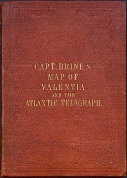
Cover
|
Inside front cover advertisement
|
Titled a map, but in the form of a broadside, with information on the Atlantic cables at Valentia and the Atlantic Telegraph Company. The print includes diagrams of the cross sections of the cable, the location of the ships of the 1858 expedition, and other historical details.
An advertisement for the map was published in the 27 May 1859 issue of the Limerick Reporter:
The map was sectioned and laid down on canvas so it could be folded into the cover shown above. The image of the map on this page has been digitally restored for clarity, and the original scan may be seen here. |
|
|
| 1859 |
Map Shewing the Submarine Telegraph between Europe and America, with its Various Communications in the Two Continents
D. Lark |
| |
|
This map is hand drawn and largely hand-lettered, and it is not known if it was ever published. However, as it has many of the features of the published broadsides for the 1858 cable, it is included here for completeness.
The title line includes coats of arms for Britain and America, and the map shows the route of the 1858 cable together with the onward land connections and the networks of telegraph lines in North America and Europe. Also shown are the steamer tracks across the Atlantic, and a table of distances for points on the cable route.
There is no reference for the maker of this map, whose name is shown only as “D Lark”. |
|
|
| 1860 |
A View of the Town and Harbour of St. John’s, Newfoundland
F.R. Page, St. John’s |
| |

A View of the Town and Harbour of St. John’s, Newfoundland.
Taken in Commemoration of the successful laying of the Atlantic Telegraph Cable shewing the Position of the Several Vessels after their return from Bay Bulls Arm, the Newfoundland Terminus.
In the accompanying Plate the large vessel on the left hand is the United States Steamship Niagara, the centre vessel H.M Steamship Gorgon and the Brig on the right further up shore H.M. Brig of War Atalanta.
Published by F.R. Page, by special request.
Drawn by W.R. Best, lithographed by W. Spreat, Exeter, England
Image courtesy of the National Maritime Museum, which has two copies of this lithograph. These give the size as 534 x 824 mm [PAI7204] and 484 x 754 mm [PAI7203]; the difference is due to the trim size of the overall sheet. Shown above is the larger version. |
Although not published until 1860, this lithograph is the only one to show the ships at Newfoundland after the landing of the cable in August 1858, and before the Niagara sailed for New York:
At a little after sunrise [August 5th, 1858]
the Niagara’s and Gorgon’s boats were ranged in line in the romantic Bay
of Bull’s Arm. The end of the cable was soon safely brought ashore, when
the three captains, with their officers and men, formed a chain for the
purpose of hauling it inland to the telegraph station, which is situated
about half a mile from the shore. This concluding operation was speedily
accomplished, and the Niagara’s share in laying the Atlantic Telegraph
was complete.
Early in the morning of
August 9th the Niagara and Gorgon left Trinity Bay for St. Johns, where
they arrived the same evening, and whence, after coaling, the Niagara
sailed for New York.
[Frank Leslie’s Illustrated Newspaper, 28 August 1858]
This announcement of the publication of the print appeared in The Public Ledger and Newfoundland General Advertiser issue of 1 May 1860:
View of the Town and Harbour of
St. John’s, Newfoundland
PUBLISHED and just received by the Subscriber, a beautifully executed Plate of the Town and Harbour, including the North and South Sides. In style and finish the artist has outvied his former works. The perspective embraces the Town and the surrounding Country, from Magotty Cove on the North side to Job’s Bridge, thence extending to the South side premises of Messrs. Baine, Johnston & Co. In the Harbour is shown the U.S.S.S. “Niagara,” and H.M. Steamer “Gorgon” and Brig of War “Atalanta,” as they lay at anchor on their return from Bay Bulls Arm after the laying of the Atlantic Telegraph Cable. The Plates are rendered at a low price, so that every householder need not be without a copy.
Engravings—15s ea.
F.R. PAGE, Publisher.
Office, No. 1,
RENOUP’S Buildings.
May 1 [1860].
|
|
|
| 1865 |
The Atlantic Telegraph (first edition)
G.W. Bacon
& Co., London |
| |
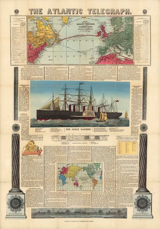
The Atlantic Telegraph
Bacon & Co., 48, Paternoster Row, London.
Image courtesy of David Rumsey Map Collection,
David Rumsey Map Center, Stanford Libraries
Overall size
~32" x 22"
|
This English broadside includes a map showing the route of the cable as well as other similar proposed and existing cables; a map of the proposed network of cables worldwide; actual size cross-sections and side views of the shore-end and deep-sea cable sections; a diagrammatic view of a telegraph register; a view of the Great Eastern under steam, and a longitudinal section of the ship; and a profile of the sea-bed between Ireland and Newfoundland, with the ships of the cable fleet above.
Note that Great Eastern is shown with five funnels, so this is a re-purposing of an existing image. For the 1865 cable expedition the middle funnel was removed to make room for the cable tanks..
The text gives the history of the laying of the cable and a great deal of related information: earlier attempts, the development of the science that enabled the cable to operate, Morse code and more.
See below for the 1866 updated edition of this broadside.
The Mechanics’ Magazine, in its edition of September 1, 1865, had this notice:
Messrs. Bacon and Co. have just published a chart of the Atlantic telegraph. It contains a history of telegraphy, origin and progress of the Atlantic telegraph, and describes the old and new cables. It is well illustrated with maps of the route, engravings of the cables and of the “Great Eastern,” showing the arrangements for laying, in fact a large amount of useful information is compressed into a small compass.
George Washington Bacon, publisher of this broadside and also of a book on the Atlantic Telegraph was born in Lockport, New York, in 1830 and moved to London in 1861. In 1862 he opened a business at 48 Paternoster Row, London, initially importing maps and atlases from Colton in New York, but soon publishing many works himself. He sold a very large range of cartographic publications and was well respected as a publisher for many years.
Bacon died in 1922, but his firm survived until 1944, and he left a fine legacy of 400 catalogued maps and atlases. The name Bacon on maps only finally vanished (under the imprint of Johnston & Bacon) in 1980. |
|
|
| 1865 |
The Great Eastern (with the New and Old Atlantic Cables)
G.W. Bacon
& Co., London |
| |
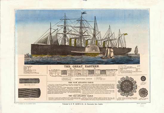
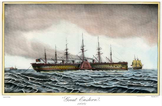
The Great Eastern
G.W. Bacon & Co., 48, Paternoster Row, London.
Price Sixpence
Overall size 13⅝" x 20" |
This English broadside by G.W. Bacon is a simpler version of the one above, also published in 1865. It shows the same views of the Great Eastern under steam and the longitudinal section of the ship, with illustrations and brief descriptions of the 1858 and 1865 Atlantic cables. As with the image above, the ship is shown with its original five funnels. |
|
|
| 1865 |
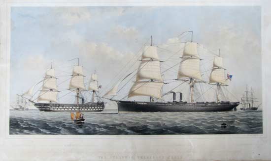
The Great Eastern Steamship James Anderson Esq. Commander with Atlantic Telegraph Cable 1865
Day & Son, London; A.J. Schenk, Artist |
| |
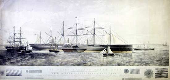
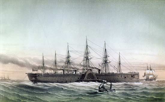
The Great Eastern Steamship
James Anderson Esq. Commander
with Atlantic Telegraph Cable 1865
T.G. Dutton Lith from a drawing in water colour by A.J. Schenk.
Day & Son (Limited) Lith.
London Published July 1st 1865 by Day & Son (Limited)
Lithographers Gate Street Lincoln’s Inn Fields.
Overall size 498 x 998 mm
(19½" x 39¼")
Image courtesy of National Maritime Museum, Greenwich, England [object PAJ2389]. |
Although this lithograph purports to show the Great Eastern loaded with the 1865 Atlantic cable, the ship still has its original five funnels, even though one of the funnels had been removed in the process of conversion for cable laying. This anachronism can also be seen in some of the other lithographs on this page which show Great Eastern, and the reason for it on this print is made clear below.
The title is printed in the text area below the image, together with illustrations of lengths and sections of the 1865 cable.
The print is “Dedicated to J. Pender Esq. M.P. (Chairman) and the Directors of the Telegraph Construction and Maintenance Company Limited.”
The 1865 print above was repurposed and retitled from an 1860 Great Eastern lithograph published by Schenk without any alteration to the illustration, which explains why the ship has the wrong number of funnels. A copy of the 1860 print is in the collection of the State Library of New South Wales and is shown below. The images are identical on the two lithographs; only the text is different.
The print is in very poor condition, and the image below is the best that could be recovered using Photoshop. In script at the bottom of the print is a dedication to Isambard Kingdom Brunel, who had died on 15 September 1859:
“This Print is Dedicated to the Representatives of the Late I.K. Brunel, Esq., the Engineer of the Great Ship Company and to his successor. R.L. Brereton, Esq., by A.J. Schenk ”
There are also some statistics of the ship:
Burden 22000 Tons
Horse Power 3000
Length overall 695 feet
Breadth of Beam 84
Ht. from Bottom to Deck 58
The Great Eastern Steam Ship
J. Vine Hall Esq. Commander
T.G. Dutton, Lith. from a drawing in water colour by A.J. Schenk.
London Published August 1st 1860 by Day & Son,
Lithographers to the Queen. Gate Street, Lincoln’s Inn Fields
Day & Son, Lith. to the Queen
Overall size 17¾" x 39½"
Image size 15¼" x 38½"
Image courtesy of State Library of New South Wales, Australia |
| |
Another copy of the original lithograph

Image courtesy of Dominic Winter Auctioneers |
|
|
|
| 1865 |
The Route of the Atlantic Telegraph, The Great Eastern, Section of the Bed of the Atlantic
William Stevens, London |
| |
|
Coloured etching, published by Stevens, 20 July 1865, London.
This broadside has at the bottom a section of the Great Eastern
showing details of its cable equipment and storage. Beneath this is a section of the bed of the Atlantic. Above the ship are cross-sections of the old (1858) and new (1865) cables.
The top half of the print illustrates “The Route of the Atlantic Telegraph, by Capt. H. Clark, R.N.” This shows both the ocean route and the onward connections to New York, London, and Europe. The proposed (but never laid) North Atlantic cable route via Greenland and Iceland is also shown.
Dominic de Cogan observes that the map’s colouring shows New Brunswick, Nova Scotia and Prince Edward Island as part of the USA, with the New Brunswick/Quebec border shown as the international border. This is of course an error on the part of the publisher, as all of these were British territories at the time.
See also the 1866 broadside by Stevens, which has a similar route map and Great Eastern section.. |
|
|
| 1865 |
Map of the Submarine Telegraph between America & Europe, with its Various Communications on the Two Continents
Korff Brothers, New York |
| |

Map of the Submarine Telegraph
between America & Europe,
with its Various Communications
on the Two Continents
Overall size 7½" x 18"
Entered according to Act of Congress in the year 1865
by Korff Brothers in the Clerk’s Office of the District Court
of
the U.S. of the Southern District of New York.
Engraved and printed by Korff Brothers, 54 William St., New York
Image courtesy of Barry Lawrence Ruderman Antique Maps, Inc. |
This map of the 1865 Atlantic cable has the same title as the one published by Korff Brothers in 1857, above, but is otherwise quite different in its depiction of the cable route and other features.
The map shows the route of the undersea telegraph cable across the Atlantic, together with with the the five principal steamship routes in the North Atlantic and the railroad lines in North America and Europe (including the yet-to-be-completed Central Pacific Railroad). An inset map of the Northern Hemisphere shows the proposed Russian & American Telegraph between St. Petersburg and San Francisco (which was abandoned after the success of the 1866 Atlantic cable). There is also the same profile of the bottom of the North Atlantic as shown on the earlier map, and illustrations of the 1858 and 1865 deep-sea cables.
This copy of the map was presumably a promotional item, issued “With Compliments of Hanover Fire Insurance Co., No. 45 Wall Street, New York,” “Cash Assets July 1st 1865, over $500,000,” but no other versions are known at present. |
|
|
| 1865 |
Steamship The Great Eastern Laying the Electrical Cable between Europe and America
Louis Le Breton |
| |
Steamship The Great Eastern Laying the
Electrical Cable
between Europe and America
|
This lithograph by the French marine artist Louis Le Breton (1818-1866) is of the Great Eastern laying cable in 1865.
The artist seems to have had little concept of how cable laying worked; the bow sheave as shown in the illustration is completely wrong. However, he does show the correct number of funnels. |
|
|
| 1865 |
Titled “Great Eastern 1858”
N.F. Diana [20th century copy of Louis le Breton lithograph above] |
| |
Great Eastern
1858
Drawn by N.F. Diana
Edizioni Ponte Vecchio
Published by P.V.5
Overall size 19½" x 27", image size 9"x 15"
|
This mid-20th-century hand-coloured photomechanical print is quite obviously an almost exact copy of the 1865 Louis le Breton lithograph above, despite its 1858 date.
Perhaps in an attempt to disguise its origins, the Edizioni Ponte Vecchio print actually has the image of the ship reversed horizontally compared with the 1865 lithograph. I have remedied this on the version shown above so that it may be more easily compared with the original.
Edizioni Ponte Vecchio was a company which produced reproductions of antique art prints. Formed in 1938 in Florence, the company offered a large number of subjects in various categories such as botany, astronomy, maps, etc. The firm went out of business in 2012 and its assets were sold at auction. |
|
|
1865 |
The Great Eastern is Coming! A Grand Carnival at Hartford, Conn. on Friday, Sept. 29th, 1865. |
| |
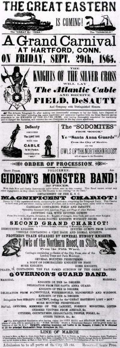
The Great Eastern is Coming!
A Grand Carnival at Hartford, Conn. on Friday, Sept. 29th, 1865.
Overall size 23" x 9" |
The Connecticut State Library at Hartford lists this broadside in its catalog, maker not stated, as a “Satyrical broadside in the form of a playbill ridiculing failure of the attempt in the summer of 1865 to lay an Atlantic submarine telegraphic cable.”
THE GREAT EASTERN IS COMING! A Grand Carnival at Hartford, Conn. on Friday, Sept. 29th, 1865. The Knights of the Silver Cross will lay The Atlantic Cable and receive Field, DeSauty and Company with Distinguished Honors. The Atlantic Telegraph Co. after making two unsuccessful attempts to lay the Cable, have disposed of their interest in the Cable including the entire machinery and apparatus together with the Great Eastern and its attendants to the Knights of the Silver Cross, who having thoroughly remodeled the machinery and re-charged the Batteries, will connect the two Continents on the day above mentioned.
The broadside satirizes the failure of the 1865 expedition.
The Terrible was in the company of the Great Eastern when the cable parted and was marked with buoys for future recovery. She steamed on to St. John’s while the Great Eastern returned to England after failing in four attempts to grapple to the surface the parted cable, which was under two miles of water.
Image and text from An Atlantic Telegraph: The Transcendental Cable by Robert Dalton Harris and Diane DeBlois. Schoharie, NY, The Ephemera Society of America, Inc., 1994, 80 pp., quarto. Reproduced here by kind permission of the authors.
The Hartford Daily Courant was the instigator of this elaborate satire. The newspaper promoted the forthcoming “event” in its issues of 28 and 29 September in the “City Intelligence” section, and the issue of 30 September 1865 had a detailed (if completely fictitious) report on the supposed proceedings.
A transcript of the broadside and the full text of all the Courant’s “reports” may be read here. These give an interesting view of mid-19th century American humor. |
|
|
| 1866 |
The Great Eastern, Leaving Sheerness with the Atlantic Telegraph Cable on Board, June 1866
Day & Son, London; R.C. Rothery, Artist |
| |
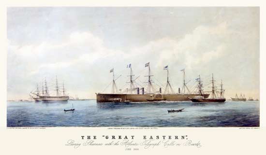
The Great Eastern
Leaving Sheerness with
the Atlantic Telegraph Cable on Board
June 1866.
T.G. Dutton Lith. from a Drawing on the Spot by R.C. Rothery.
London Published by Day & Son Limited Gate Street Lincoln’s Inn Fields.
Overall size 593 x 910 mm
(23¼" x 35¾")
Image courtesy of National Maritime Museum, Greenwich, England,
which has two copies [objects PAI6633 and PAH9040]. |
This lithograph shows Great Eastern with four funnels, correct for the cable era, and the ship is flying six flags, including those of Britain, France, and the United States.
The same scene (with the same title) was depicted in the Illustrated London News issue of 14 July 1866, but with a somewhat different view of the ships.
One of the catalogue entries at the NMM [PAH9040] notes that this copy of the hand-coloured lithograph was in the Science Museum exhibition “Submarine Telegraphy, 1973-4” and lists the size as 498 x 811 mm (19½" x 32"). The difference in size between the NMM’s two copies is due solely to the trim of the overall sheets.
R.C. Rothery is quite possibly R. Cadogan Rothery, for whom I find records of three nautical watercolours: “Wreck of HMS Eurydice” (1878); “The Thames at Richmond” (1880), “The Approaching Storm” (1882). Two of the listings have his name as R. Cadogan-Rothery. |
|
|
| 1866 |
The Atlantic Telegraph (second edition)
G.W. Bacon
& Co., London |
| |
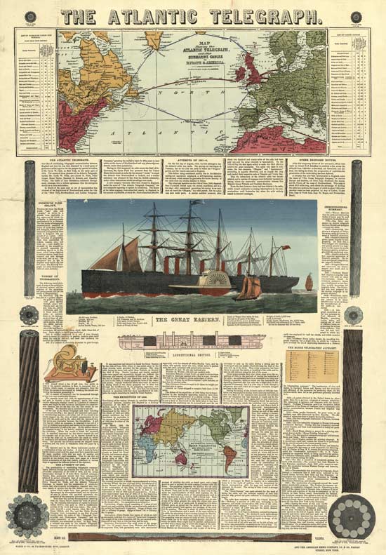
The Atlantic Telegraph
Bacon & Co., 48, Paternoster Row, London
and the American News Company, 119 & 121, Nassau Street, New York
Overall size 30¾" x 22¾" |
This edition was printed by woodcut and letterpress, then hand coloured. This copy of the broadside was laid on canvas, folded into twenty, and presented in book form between boards. A flat version was also available.
Although at first glance identical to Bacon’s large format broadside of 1865 (above), this version has additional text on the cable laid that year, and some differences in the illustrations. The same cuts of the Great Eastern (with the incorrect five funnels) were used on all three of Bacon’s broadsides. |

Front cover |
Inside front cover |
Bacon’s
Chart
of the
Atlantic Telegraph
Containing a History of Telegraphy, Origin and Progress of the Atlantic Telegraph, Description of the Old and New Cables, etc., etc; Illustrated by Maps, Engravings, Diagrams, etc. |
Price in Boards,
Two Shillings
| Mounted |
on |
cloth, |
in Case |
4s. 0d. |
| do. |
|
do. |
Roller and Varnished |
5s. 0d. |
London
G.W. Bacon & Co, Publishers & Booksellers
48, Paternoster Row
Harrild, Printer, London. |
|
|
| 1866 |
The Atlantic Telegraph
William Stevens, London |
| |
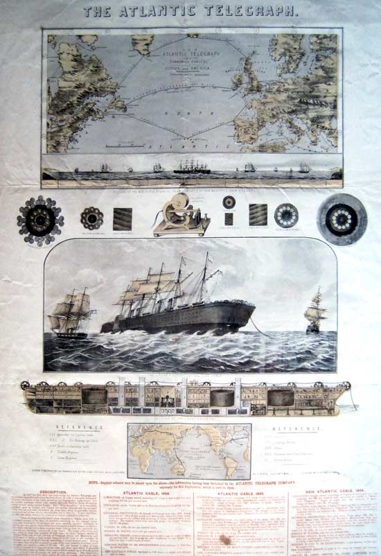
The Atlantic Telegraph
London Published for the Proprietor by William Stevens
82 Aldgate, 14th July 1866
Overall size 29¼" x 21" |
Chromolithograph broadside, published by William Stevens, 14 July 1866, London. 21" x 29¼"
“The Atlantic Telegraph and other submarine Cables, in Europe and America.” map shows [Shaffner’s] proposed North Atlantic line and the proposed French South Atlantic line. “Section of the Bed of the Atlantic, from Surveys of her Majesty’s Ship Cyclops” above which the Great Eastern is laying cable on an ocean populated otherwise by vessels under sail. Cross sections of the cables of 1865 and 1866 in conjunction with the much smaller 1858 are compared on either side of a “telegraph apparatus” resembling a Morse register. “The Great Eastern Laying the Cable” in the company of the Terrible and the Sphinx. “Section of the Great Eastern” above a numbered “Reference” labeling its parts. “Proposed Ocean Telegraphs and Overland Route Round the World” -map that includes the Collins Overland Extension of Western Union still in progress which remains to complete the global girdle. “NOTE: - Implicit reliance may be placed upon the above - the information having been furnished by the Atlantic Telegraph Company, expressly for this Publication, which is used by them.” “DESCRIPTION. ... A new expedition in 1865 also failed, whether by accident or wanton mischief is unknown....” Comparison of the statistics of the 1858, 1865 and 1866 cables.
Image and text from An Atlantic Telegraph: The Transcendental Cable by Robert Dalton Harris and Diane DeBlois. Schoharie, NY, The Ephemera Society of America, Inc., 1994, 80 pp., quarto. Reproduced here by kind permission of the authors.
See also the 1865 broadside by Stevens, which has a similar route map and Great Eastern section.
|
|
|
| 1866 |
The Eighth Wonder of the World: The Atlantic Cable
Kimmel & Forster, New York |
| |
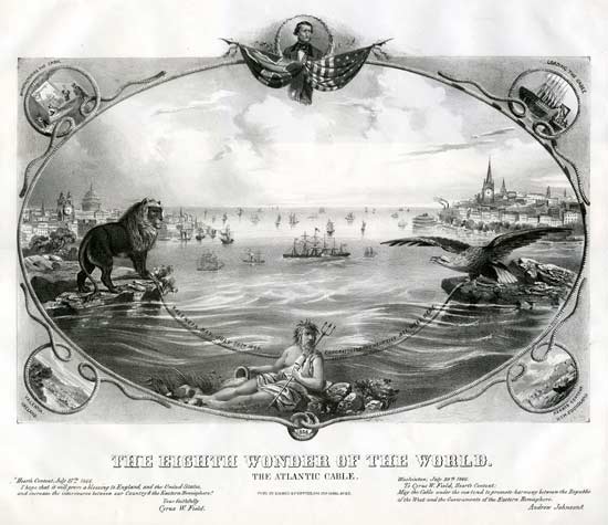
The Eighth Wonder of the World
The Atlantic Cable
Pub’d by Kimmel & Forster, 254-256 Canal St. N.Y.
Monochrome version, as issued
Overall size 18¾" x 23½" |
This lithograph shows the cable extending from the paws of a lion, symbolizing Great Britain, to the talons of an eagle, symbolizing the United States. Along the length of the cable is the message: “Valencia Bay, July 26th 1866. Congratulate you heartily all well here.”
Around the scene is an oval cable border, and at the top is a portrait of Cyrus W. Field flanked by the British and American flags. At the bottom is the date of the successful laying of the cable, 1866, with a portrait of Neptune above. The cities of London and Manhattan are illustrated at either side of the image, with a fleet of ships in between, the Great Eastern in the forefront. Clock towers in each city show the five-hour time difference between the two countries now connected by the cable (although the direct connection was actually between Ireland and Newfoundland)..
The four corner vignettes are titled: “Manufacturing the Cabel [sic],” “Loading the Cable,” “Valentia, Ireland,” and “Hearts Content, New Foundland.”
In the lower margin are statements by Cyrus Field:
“Heart’s Content, July 27th , 1866 .
I hope that it will prove a blessing to England, and the United States, and increase the intercourse between our Country & the Eastern Hemisphere.
Yours Faithfully
Cyrus W. Field.”
and U.S. President Andrew Johnson:
“Washinton [sic], July 29th, 1866.
To Cyrus W. Field, Heart’s Content:
May the Cable under the sea tend to promote harmony between the Republic of the West and the Governments of the Eastern Hemisphere.
Andrew Johnson.”
Christopher Kimmel (b. 1830) was a German-born engraver, lithographer and printer, active in New York City from 1850 to 1876. He was with Capewell & Kimmel from 1853 to 1860, and later with Kimmel & Forster and Kimmel & Voight.
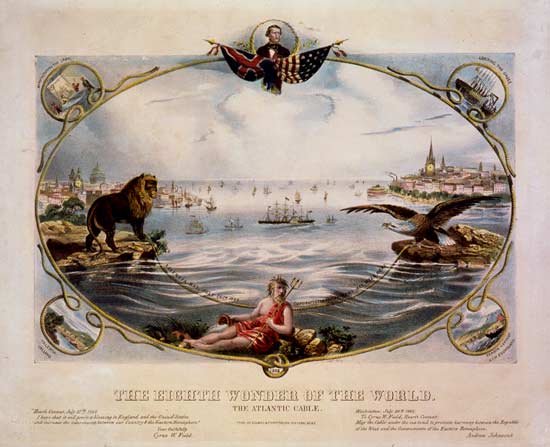
Hand-coloured version at the Library of Congress
|
| A copy in the Atlantic Cable Website archive has a somewhat different colour scheme, confirming
that these versions were coloured by hand rather than printed in colour. |
According to America on Stone, Kimmel & Forster published at least one other Atlantic cable lithograph (see next entry), as well as Civil War and genre prints. |
|
|
| 1866 |
The Arrival of the Atlantic Cable, in New Foundland, July 27th 1866
Kimmel & Forster, New York |
| |
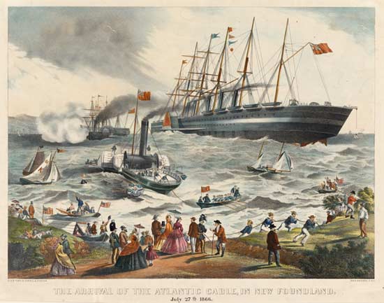
The Arrival of the Atlantic Cable in New Foundland, July 27th 1866
Lith. & Pub’d. by Kimmel & Forster, 254 & 256 Canal St. N.Y.
Overall size 17" x 20¾"
Image courtesy of
Yale University Art Gallery
Mabel Brady Garvan Collection |
This color lithograph is mentioned in America on Stone (print edition), and Yale University Art Gallery has the image shown above in its collection. The lithograph shows the Great Eastern close to the shore at Heart’s Content in Trinity Bay, Newfoundland, on 27 July 1866, accompanied by several smaller ships and boats, with a well-dressed crowd watching as seamen haul the end of the cable on to land.
Henry Field, Cyrus Field’s brother, describes the scene in his book History of the Atlantic Telegraph:
In England the progress of the expedition was known from day to day, but on this side of the ocean all was uncertainty. Some had gone to Heart’s Content, hoping to witness the arrival of the fleet, but not so many as the last year, for the memory of their disappointment was too fresh, and they feared the same result again. But still a faithful few were there who kept their daily watch. Two weeks have passed. It is Friday morning, the twenty-seventh of July. They are up early and looking eastward to see the day break, when a ship is seen in the offing. She is far down on the horizon. Spy-glasses are turned toward her. She comes nearer—and look there is another and another. And now the hull of the Great Eastern looms up all-glorious in that morning sky. They are coming! Instantly all is wild excitement on shore. Boats put off to row toward the fleet. The Albany is the first to round the point and enter the Bay. The Terrible is close behind. The Medway stops an hour or two to join on the heavy shore end, while the Great Eastern, gliding calmly in as if she had done nothing remarkable, drops her anchor in front of the telegraph house, having trailed behind her a chain of two thousand miles, to bind the old world to the new.
The image is signed in the stone: “F[eodor] Fuchs”. In 1876 Fuchs created one of the earliest images of “Custer’s Last Charge”. |
|
|
| 1866 |
Dragging for the Cable of 1865.
Heaving up the Cable of 1865.
by Captain Charles Chapman
Day & Son, London |
| |
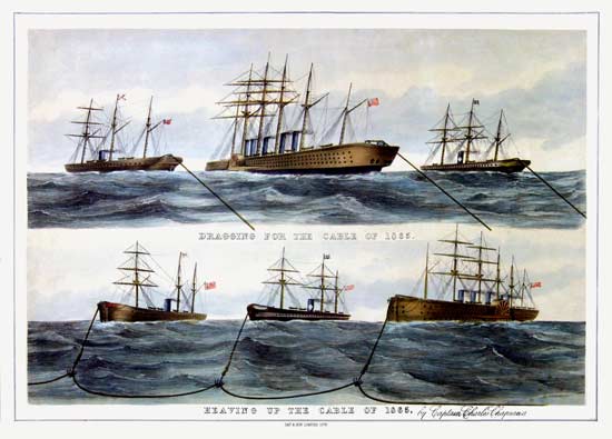
Dragging for the Cable of 1865.
Heaving up the Cable of 1865.
by Captain Charles Chapman
Day & Son Limited Lith
Overall size 558 x 745 mm
(
22" x 29¼")
Image size 465 x 685 mm
(18.3" x 27")
Image courtesy of National Maritime Museum, Greenwich, England
[object PAH9039] |
This lithograph is the latest-known published image commemorating the first Atlantic cables. It is the only one which shows the recovery of the 1865 cable from a depth of 12,000 feet.
The NMM catalogue entry lists the ships shown in this lithograph as “The Great Eastern, Medway and Albany,” but the object connections section incorrectly has “Ladway” instead of “Medway”.
The lithograph is split horizontally into two sections, each with its own illustration. The top one shows the three ships (in late August / early September 1866) dragging for the cable of 1865; the second illustration shows the cable hooked by grapnels from all three ships. The Great Eastern is incorrectly shown with five funnels, as in a number of the other prints on this page.
A description by Edward Bright of the recovery of the 1865 cable may be read here. |
|
|
| 1870 |
Breaking Up of the Agamemnon
Sir Francis Seymour Haden |
| |
The Breaking Up of the Agamemnon
Signed in the plate “Seymour Haden 1870”
First impression from the plate, J.W. Huffington publisher
A. Barry Etcher
Overall size 10½" x 18"
Plate size 7¾" x 15" |
Although neither a broadside nor a lithograph, this fine-art etching by Seymour Haden makes an appropriate closing image for this page, as it shows the breaking up of HMS Agamemnon in 1870, in sad contrast to the ship in her prime as illustrated in the 1857 lithograph above.
National Museums Liverpool has a blog post on this etching and some related works in its collection.
Sir Francis Seymour Haden, born in 1818, was a surgeon by profession, and his many works, for which he was rated the foremost etcher of Great Britain, were done during his hours of relaxation. He was knighted in 1894 and died in 1910.
HMS Agamemnon, launched in 1852, was the last surviving wooden-hulled battle ship in the British navy, and Haden’s picture of her dismantling off the British coast near Greenwich, with the sun setting, exemplified an “end-of-the-line” theme that has had enduring appeal through the ages. The print, according to contemporary accounts, was both a critical and commercial hit, selling in large numbers.
Of Haden’s creation of the print, in his 1923 book “The Etchings of Sir Francis Seymour Haden, P.R.E.” Malcolm C. Salaman wrote:
And now, having been moved to etching interest by the Thames below London, he found there, though not so far below, a splendid motive which he used to such rich artistic purpose, that in Breaking-up of the “Agamemnon” he gave us one of the great classics of the art. The story of this famous etching is something of a human document. Haden was now 52, and, with head and eyesight constantly taxed by his surgical practice, he was beginning to lose a little confidence in his power to work directly on copper out of doors; but, to redeem his promise to etch a plate for Hamerton’s new art-magazine, “The Portfolio," the fee for which was to go to the Royal Hospital for Incurables, he went one day in July, 1870, down to Deptford, and there on the copper drew the hulk of the old battleship “Agamemnon” then being broken up— a masterly drawing, though, as he confessed, he “never undertook a more perplexing job.” At first he feared the size of the ship on the plate would militate against its pictorial treatment; but in diffidently offering it to the editor he wrote: “I had thought of making the sun set behind the old hulk and the distant cupolas of Greenwich, and of using the sinking luminary as typical of the departing glories of both, and I will try to do this yet.” Haden tried and he succeeded completely, the result being an artistic achievement with the etched line which for sheer expressiveness, produced by harmonious beauty of composition, by the masterly balance of light and shade telling together their glowing story of the sunset sky and the animate river, by the absolute pictorial significance of every line, has never in its own genre been surpassed, if ever equalled.
|
|
|
| |
Bill Glover adds these notes on the British flags seen on some of the broadsides:
The flag of Great Britain is the Union Flag (or Union Jack, as it’s often wrongly called), but this can only be flown on a ship when either the Admiral of the Fleet or the Monarch is on board. It’s otherwise illegal for anyone to fly the Union flag on board ship, and has been since the reign of Charles II, when he made it so to prevent merchant ships flying it to avoid paying harbour dues.
The White Ensign is flown by the Royal Navy, the Red Ensign by the Merchant Navy, and the Blue Ensign by members of the Royal Naval Reserve (RNR) under Warrant from the Lords of the Admiralty.

White Ensign |

Red Ensign |

Blue Ensign |
|
The 1858 “Telegraph Chart, America and Europe” shows the Red Ensign on the British section of the broadside. Used by the Merchant Navy, it would have been flown at the stern by HMS Agamemnon, although as a Naval vessel she would have customarily flown the White Ensign.
The 1858 “Torchlight Procession Around the World” shows the White Ensign on the ship at the right of the broadside, HMS Agamemnon, below the portrait of Morse. This would also have been flown by HMS Leopard, one of the escorts.
The Great Eastern can be seen flying the Red Ensign in the three G.W. Bacon broadsides of 1865 and 1866.
I don”t know where the artist found the flag used on the 1866 “The Eighth Wonder of the World: The Atlantic Cable” broadside, but it certainly isn”t British.
|
|
|
|

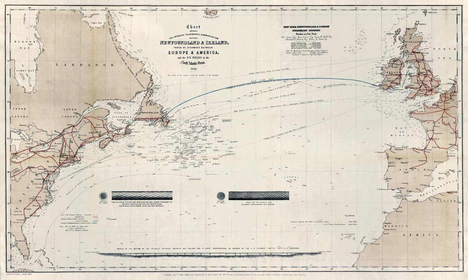
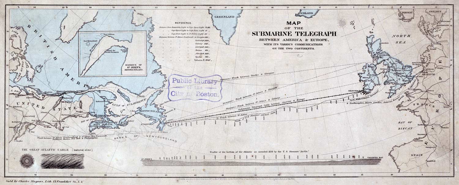
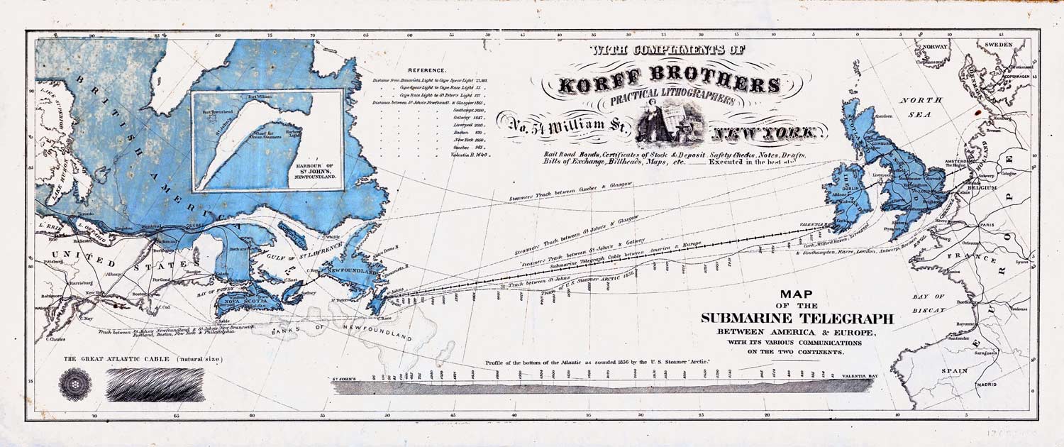
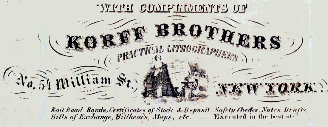
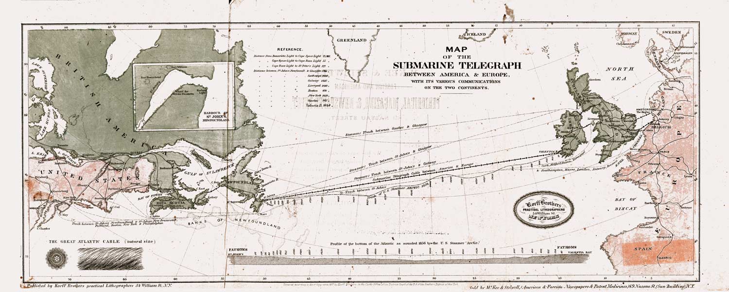
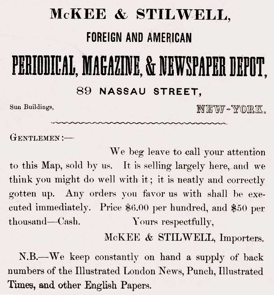
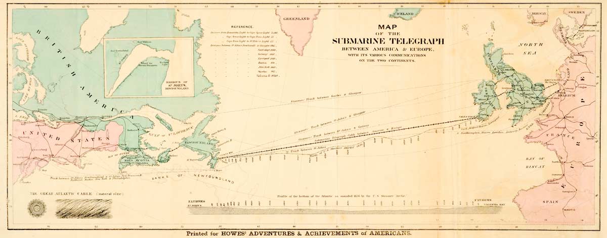
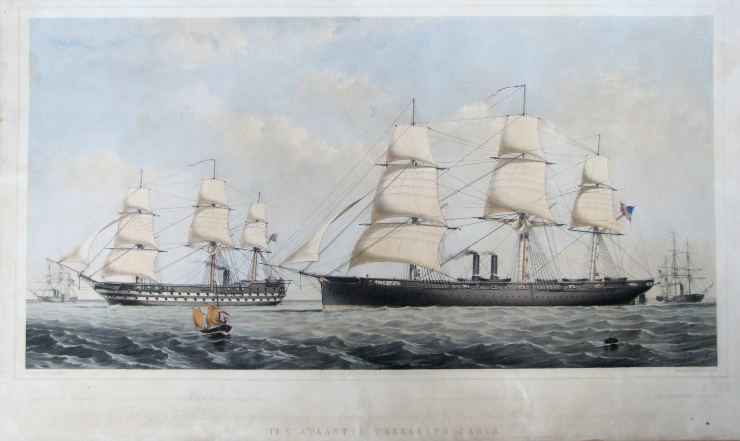
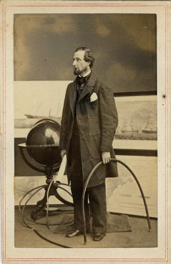
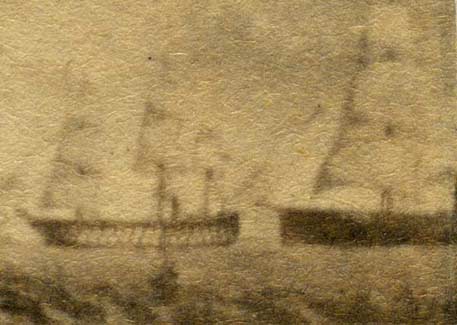
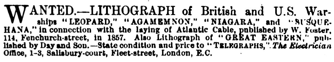
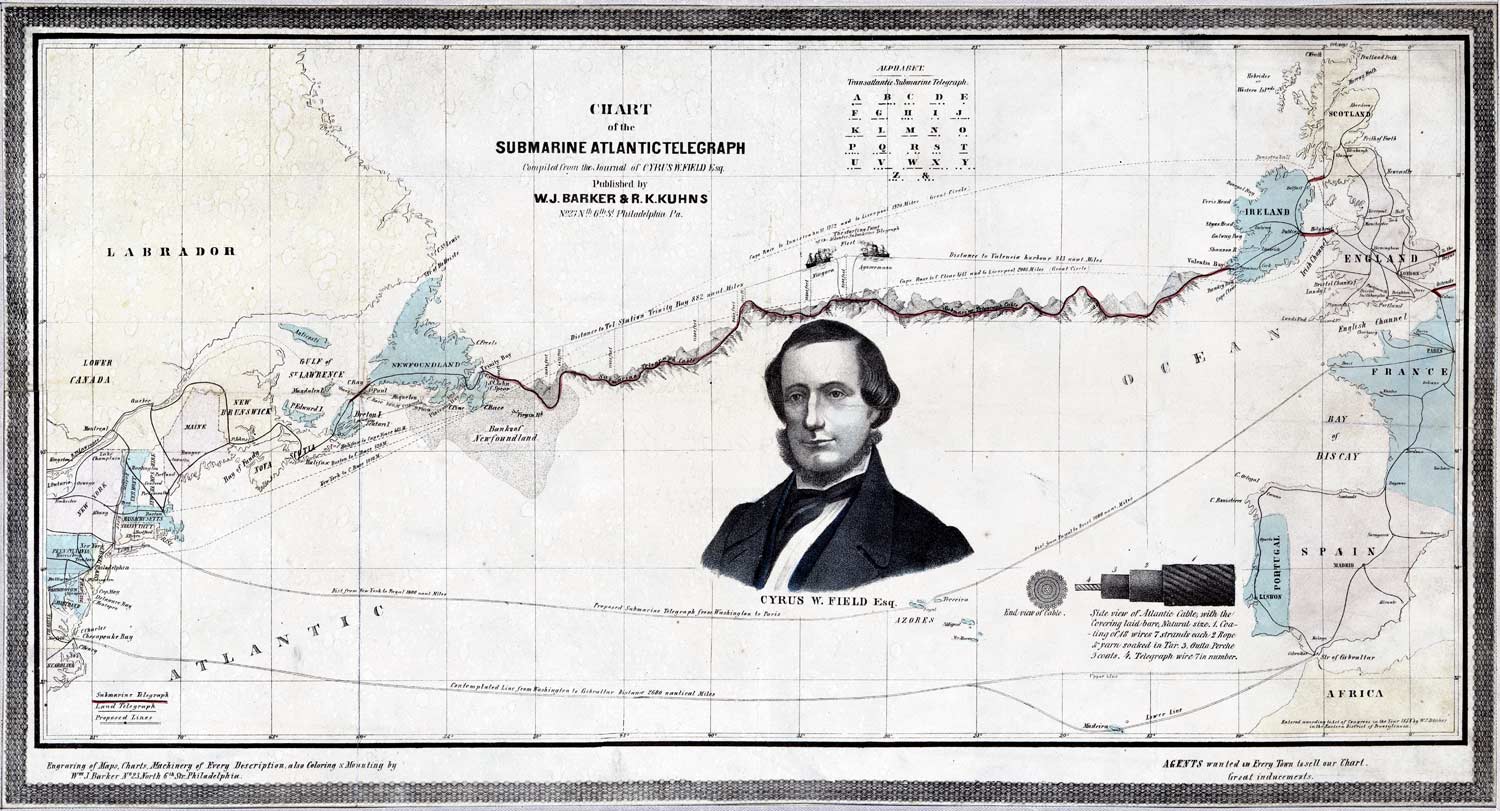
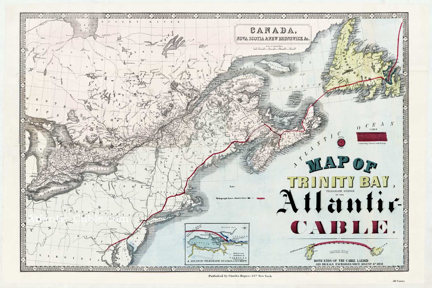
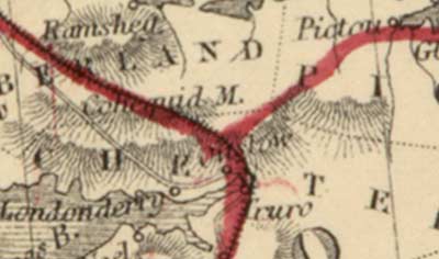
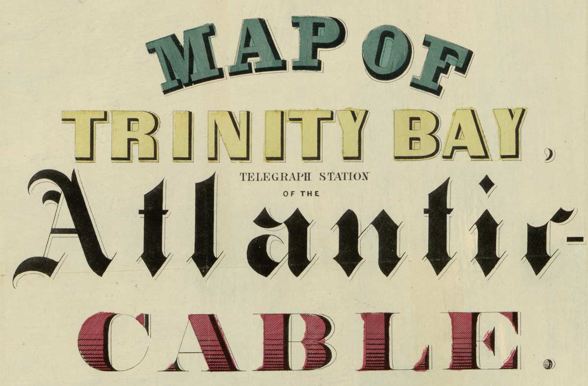
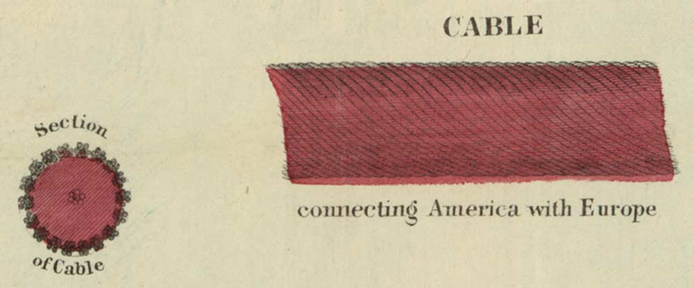
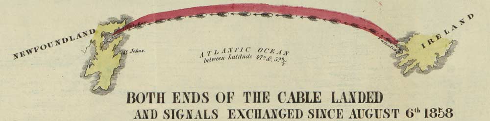
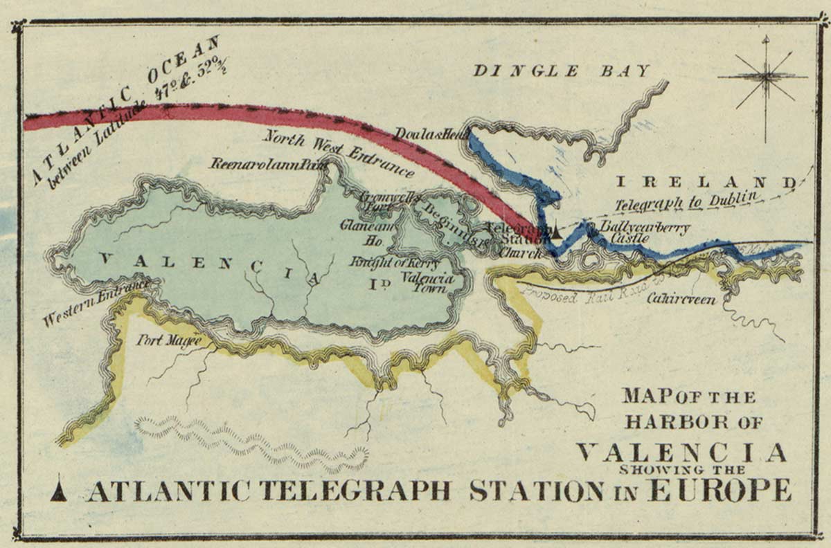
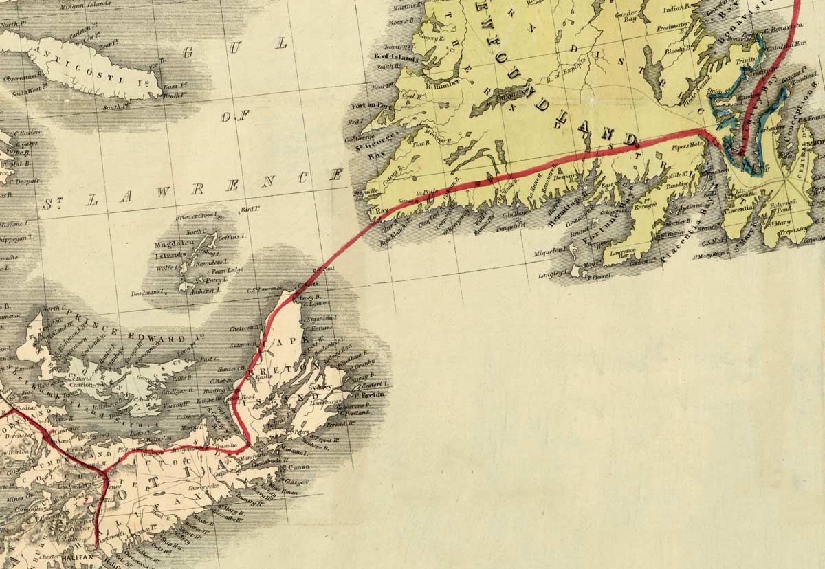
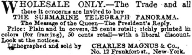
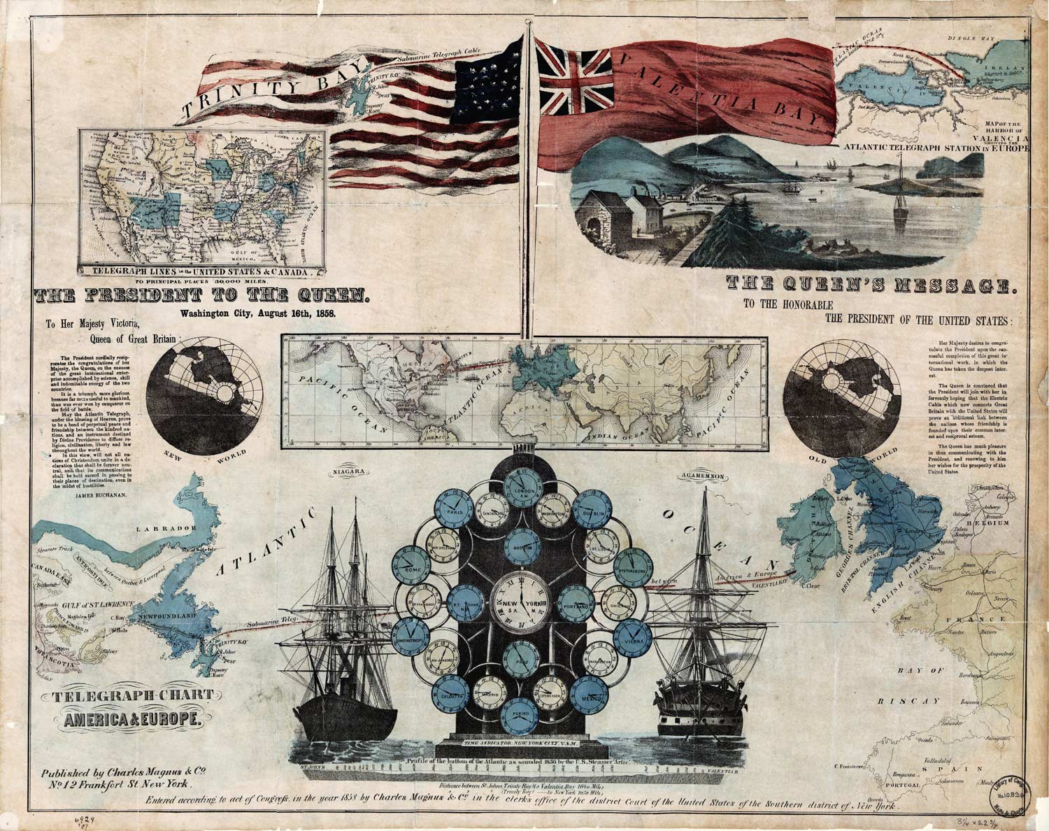
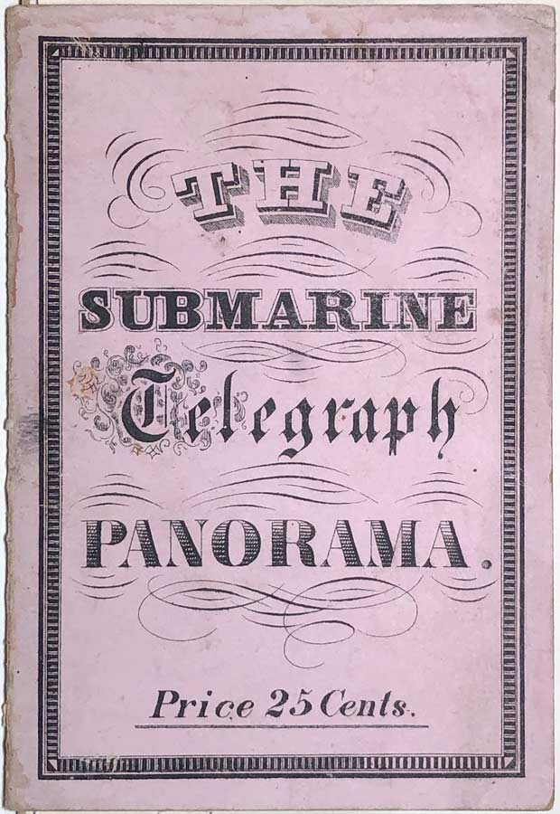
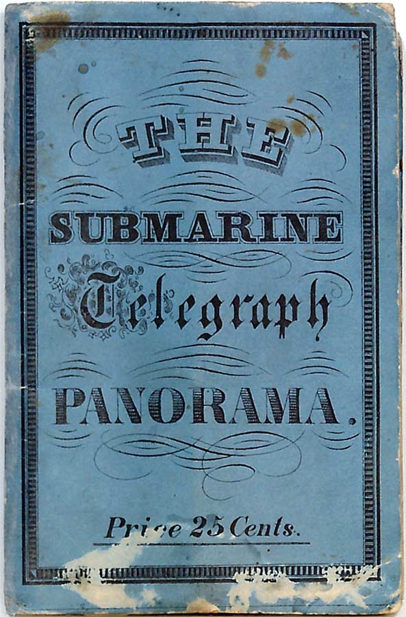
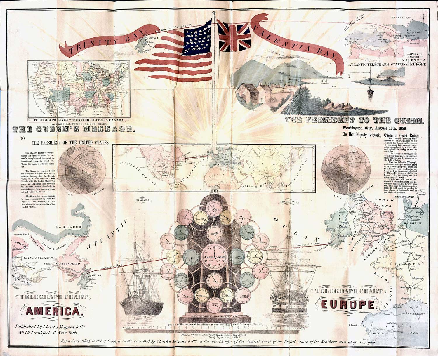
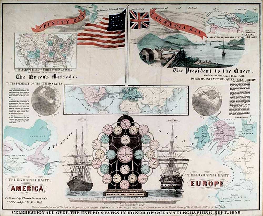
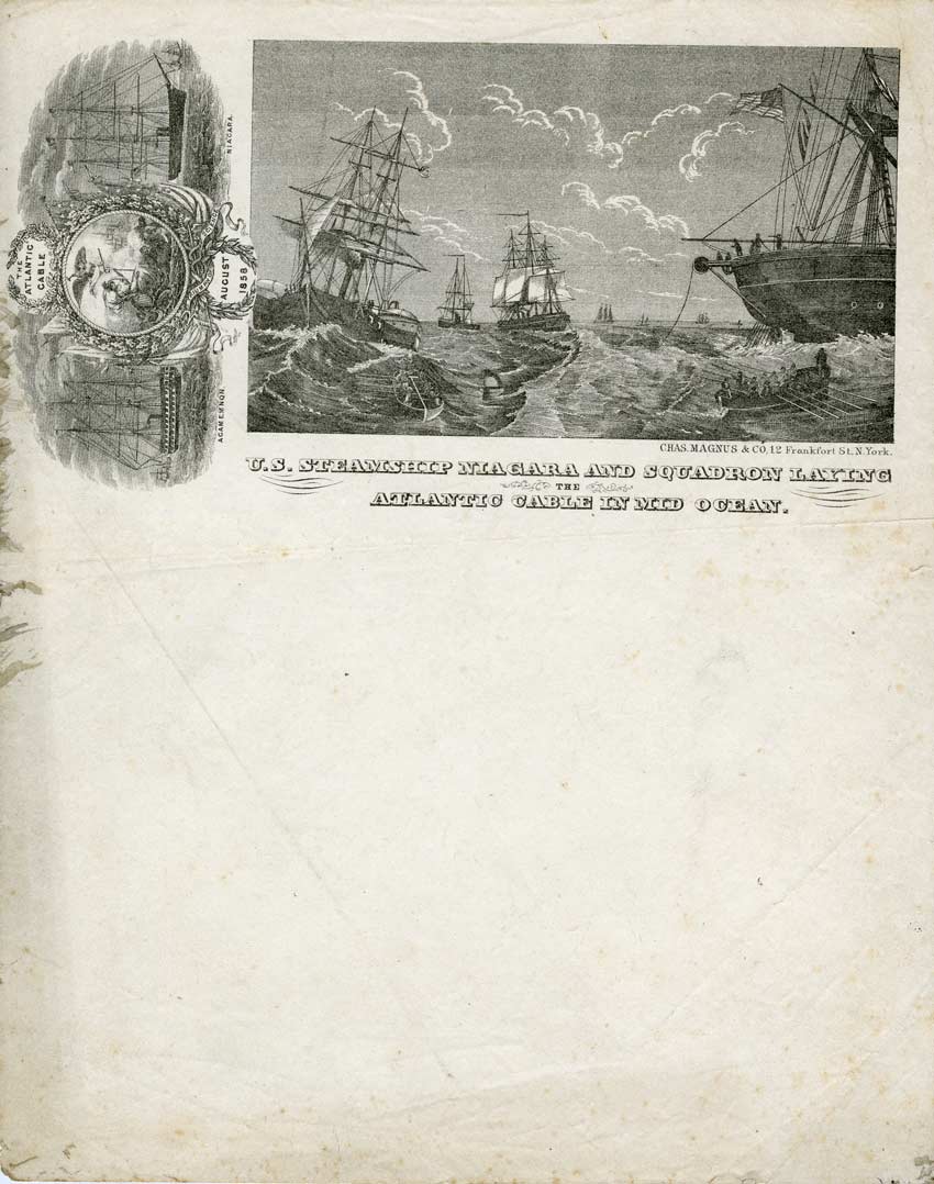
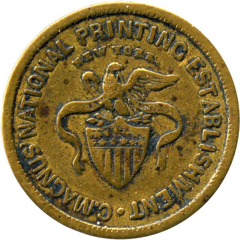

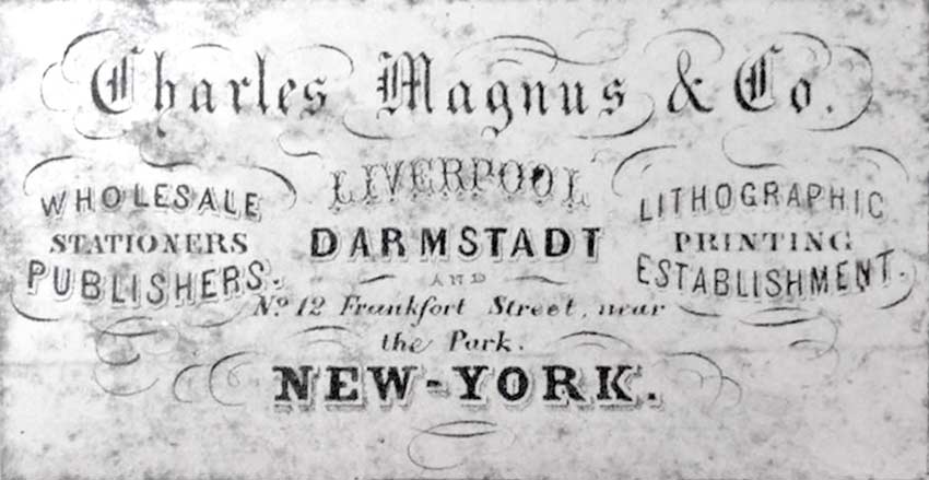
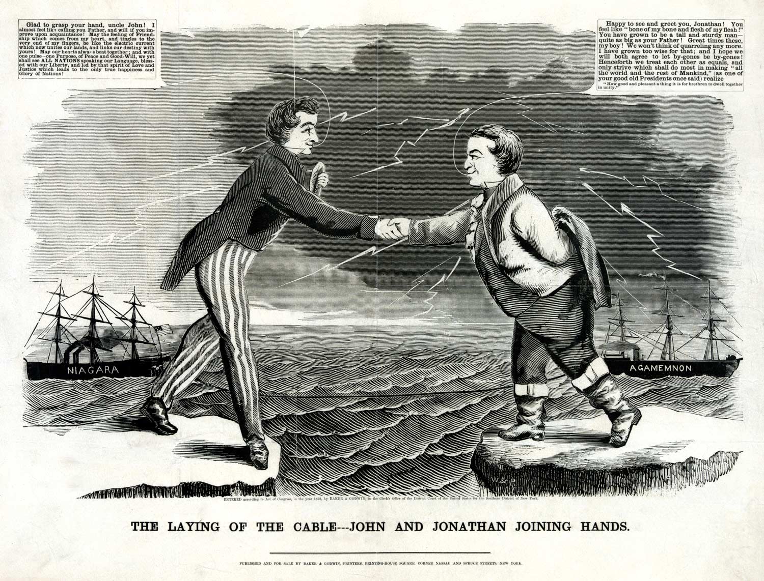
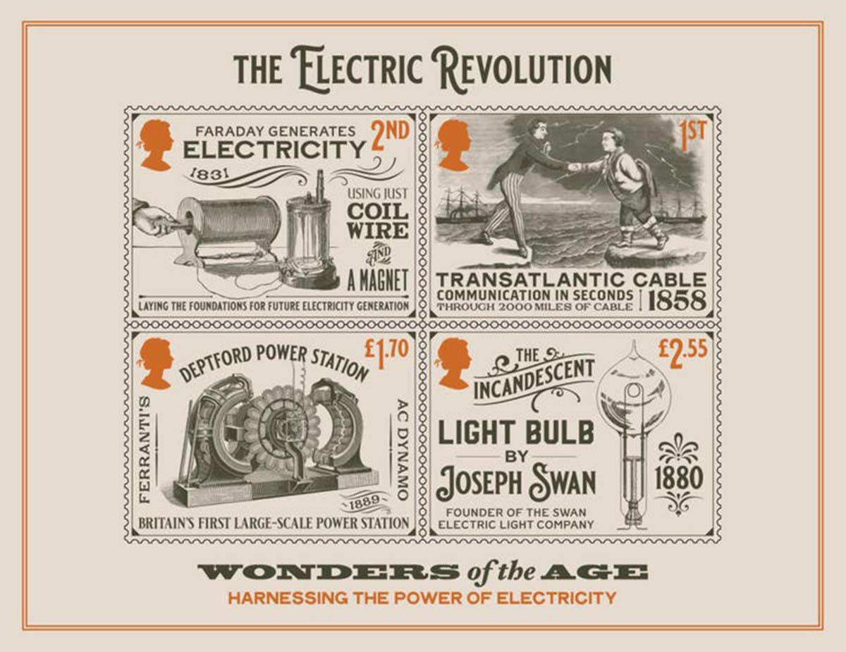
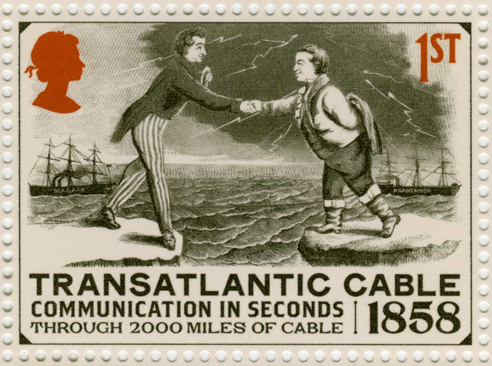
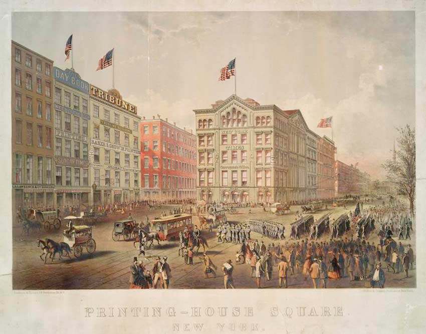
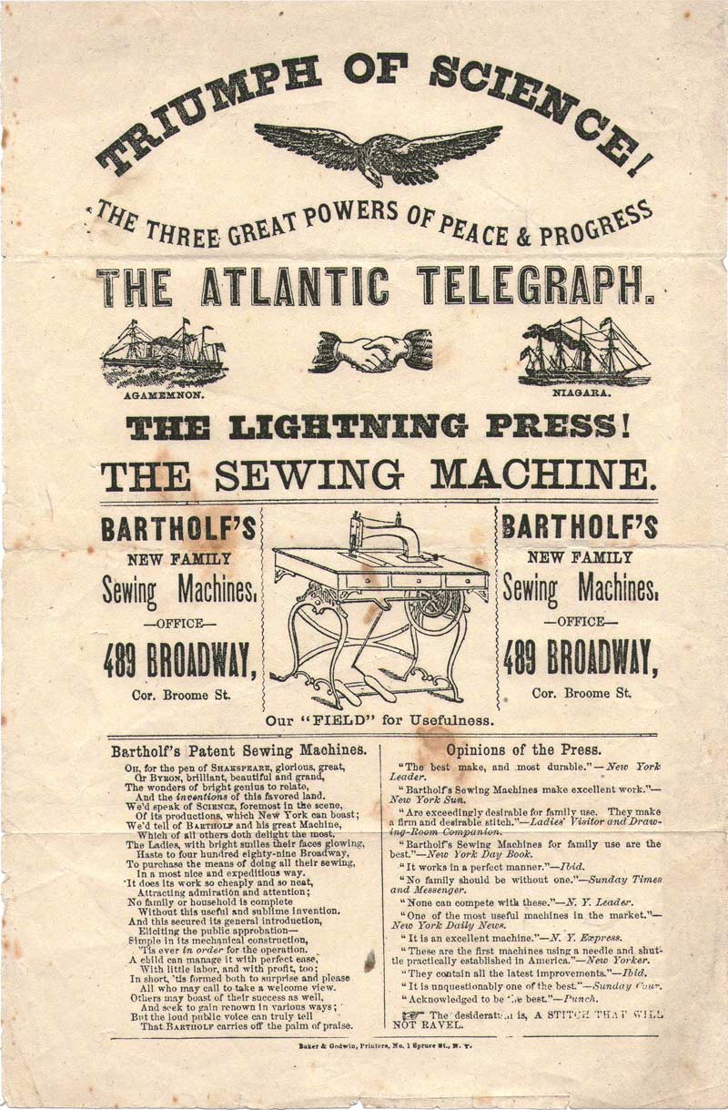
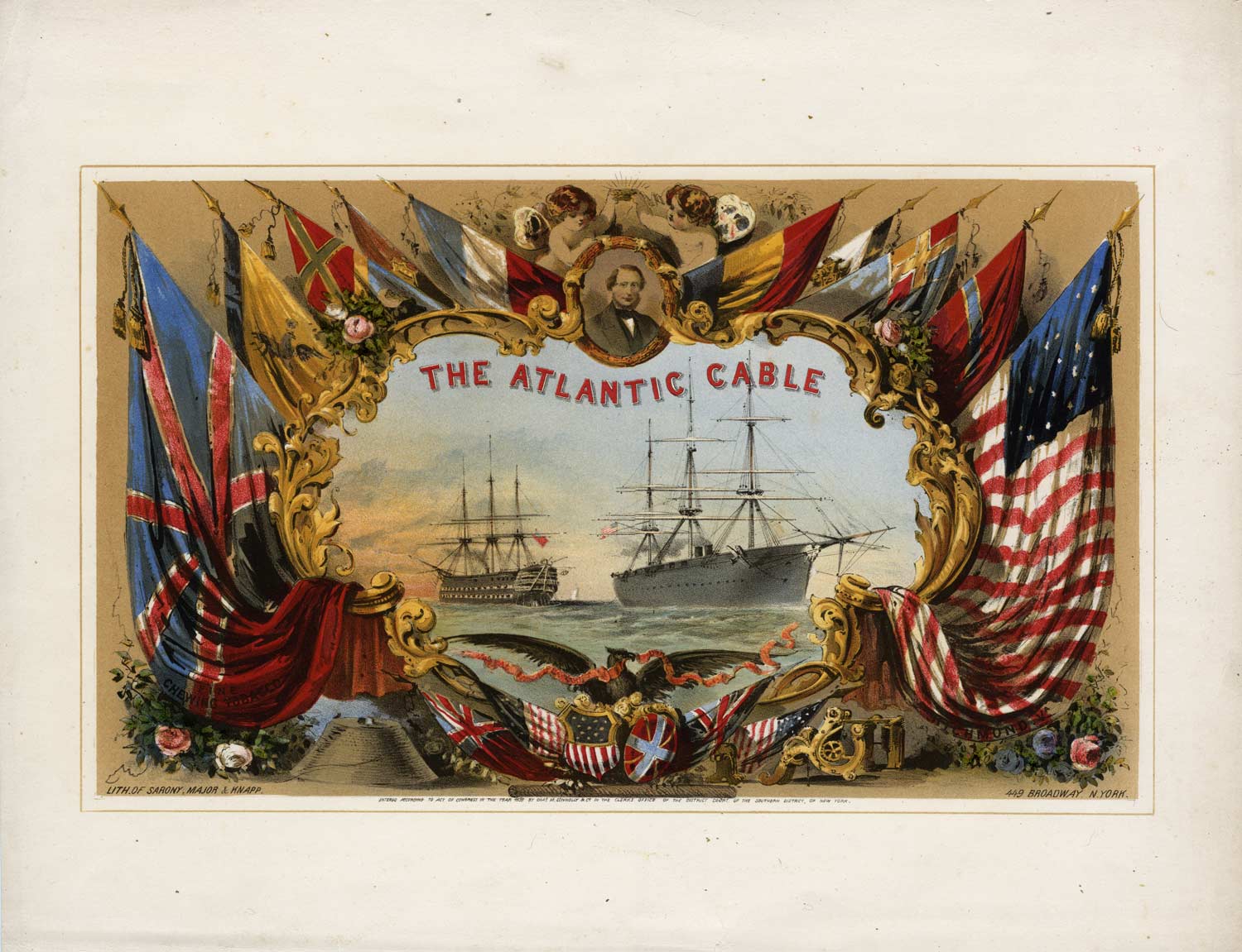
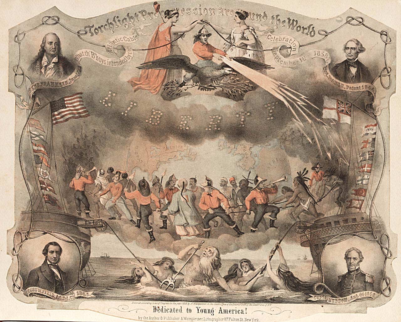
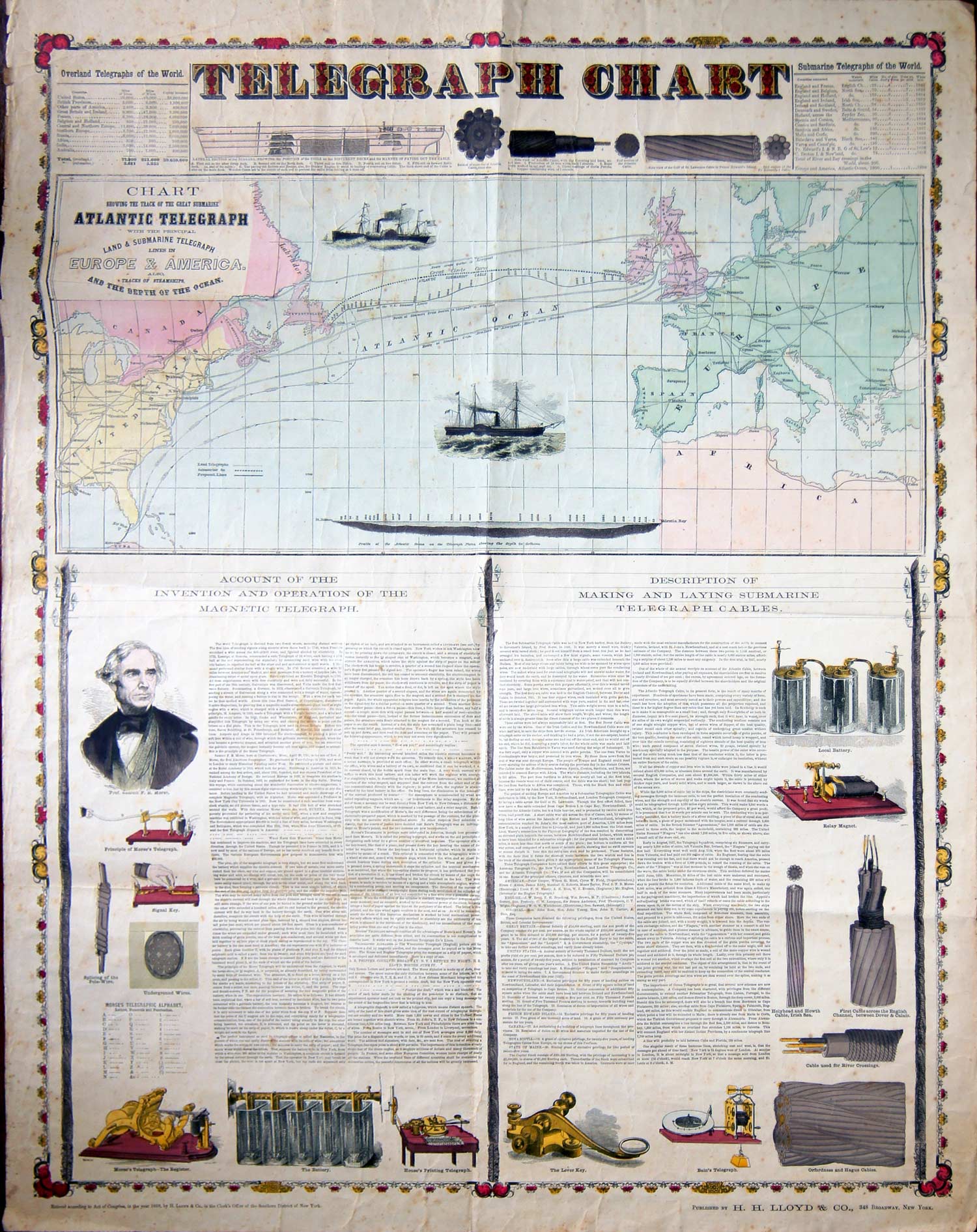
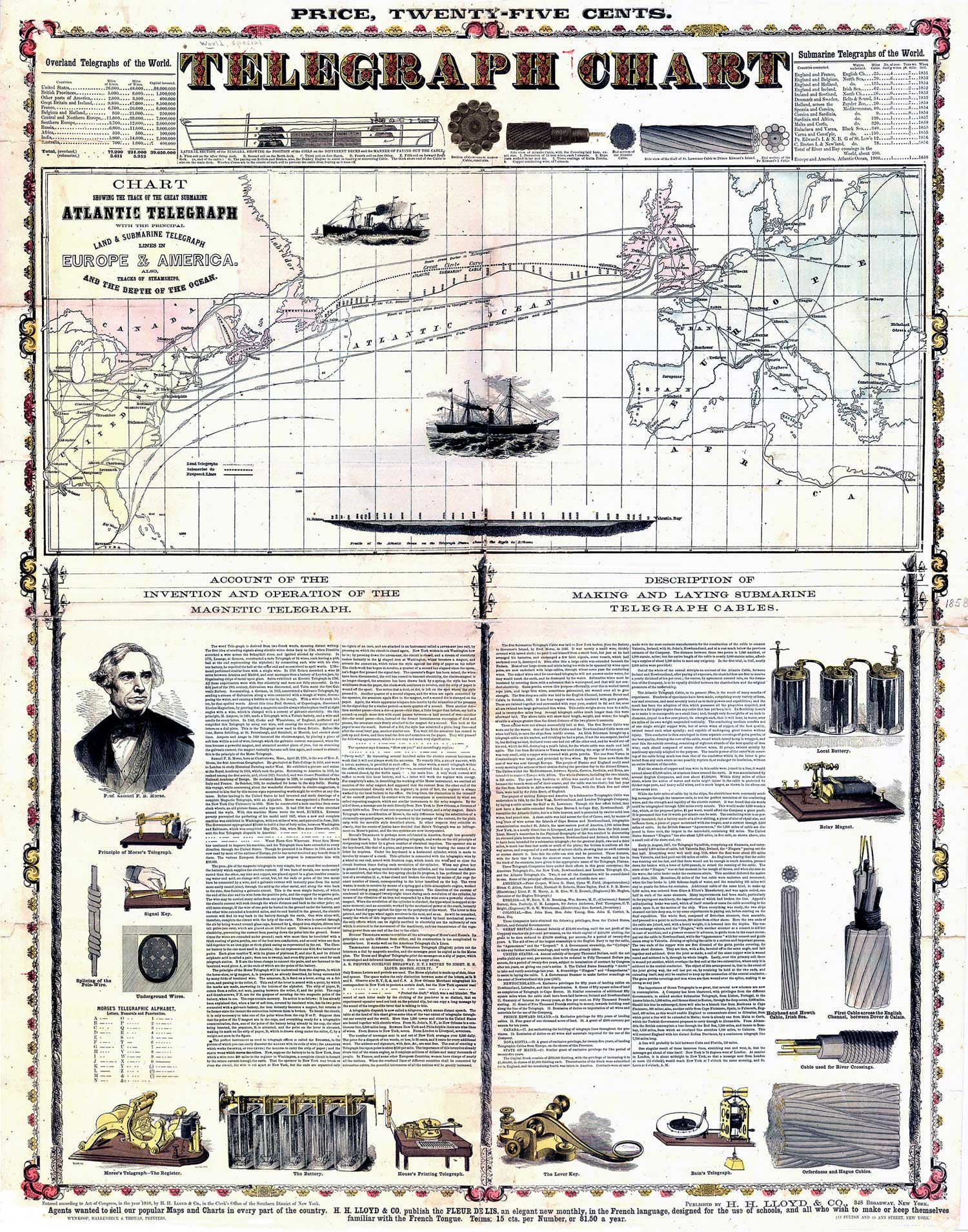
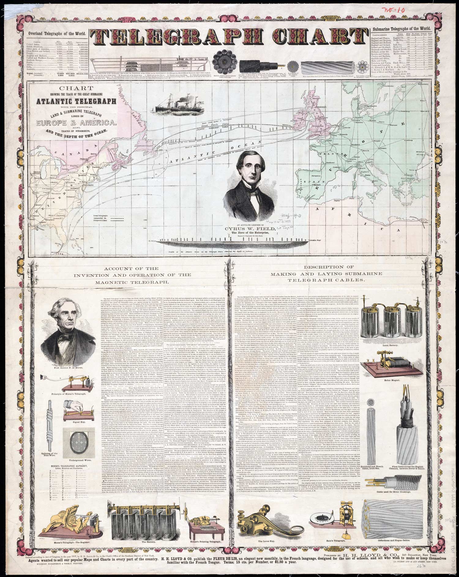
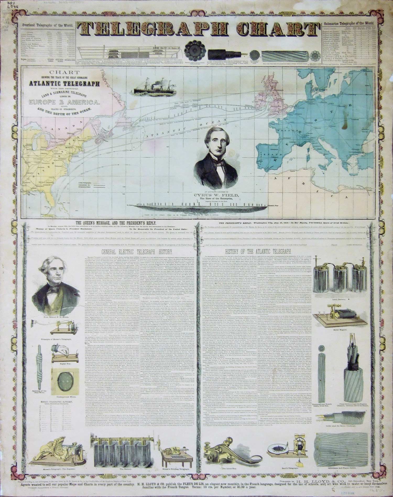
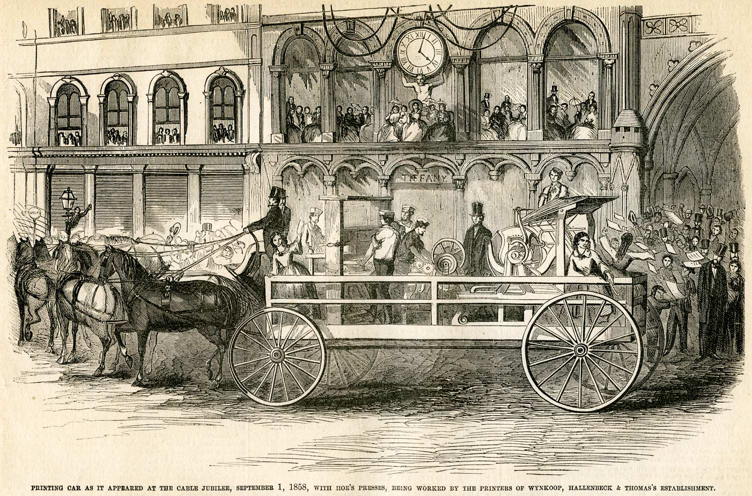

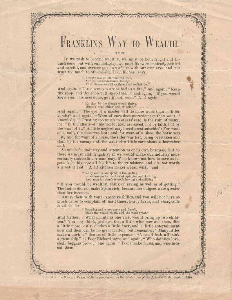
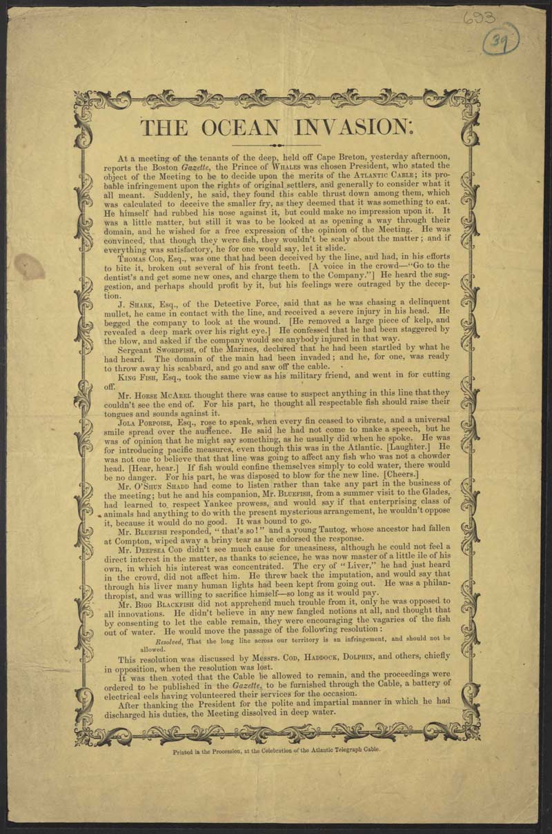
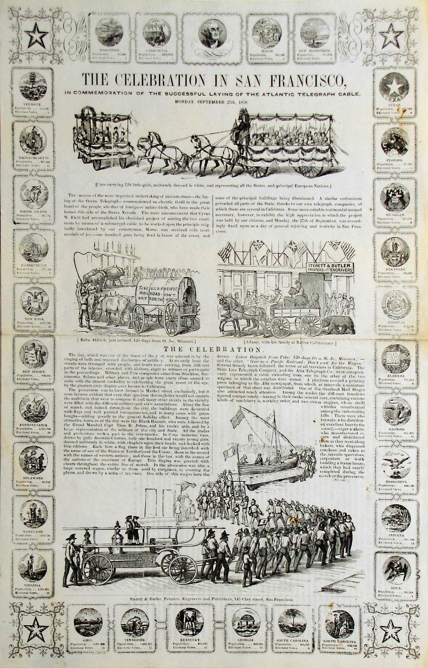
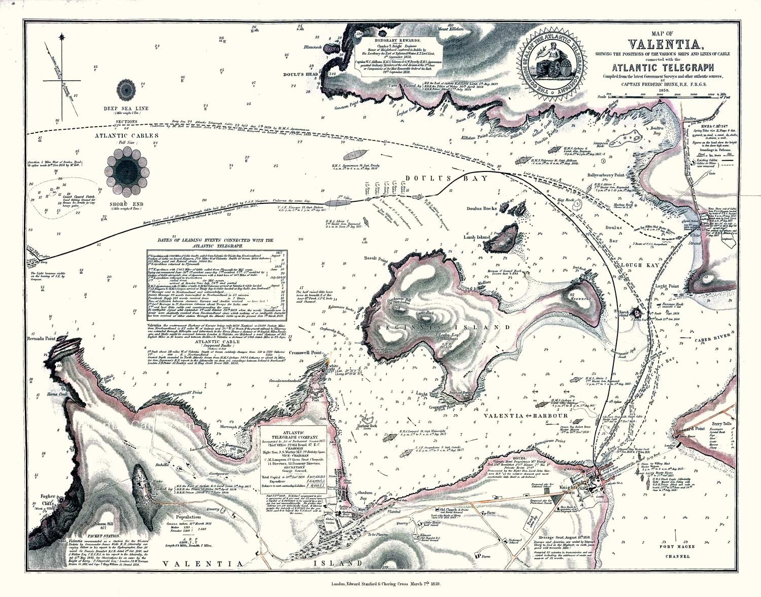

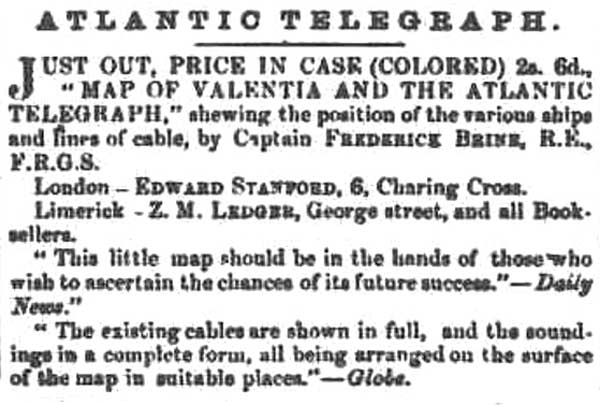
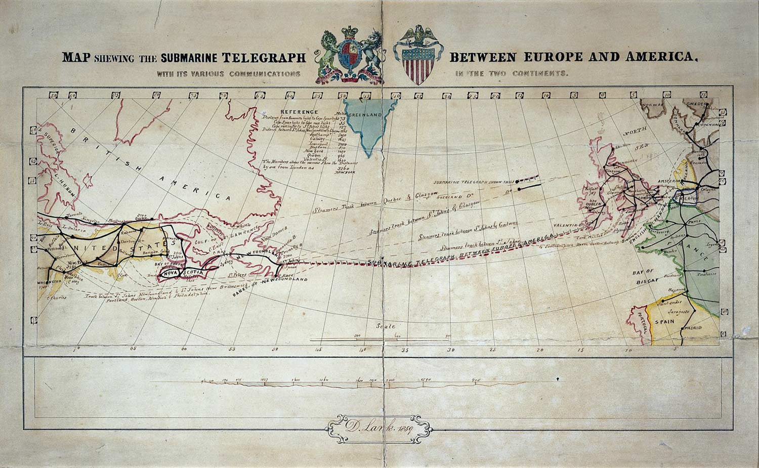
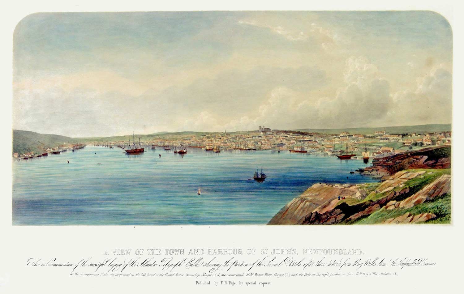
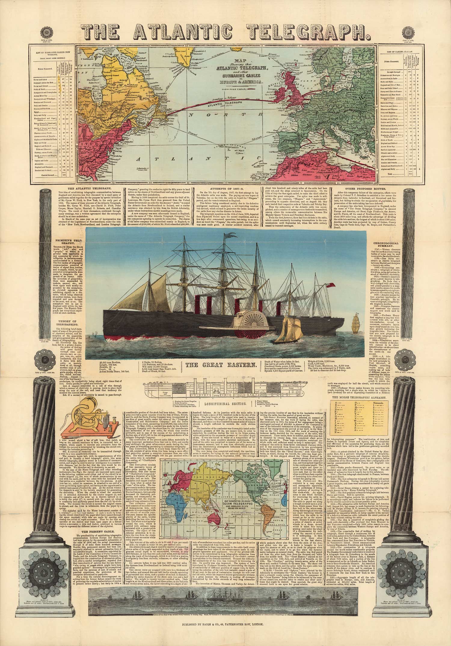
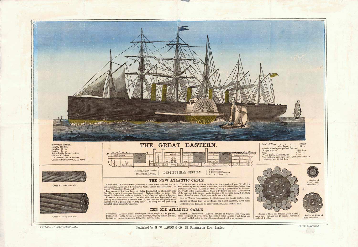
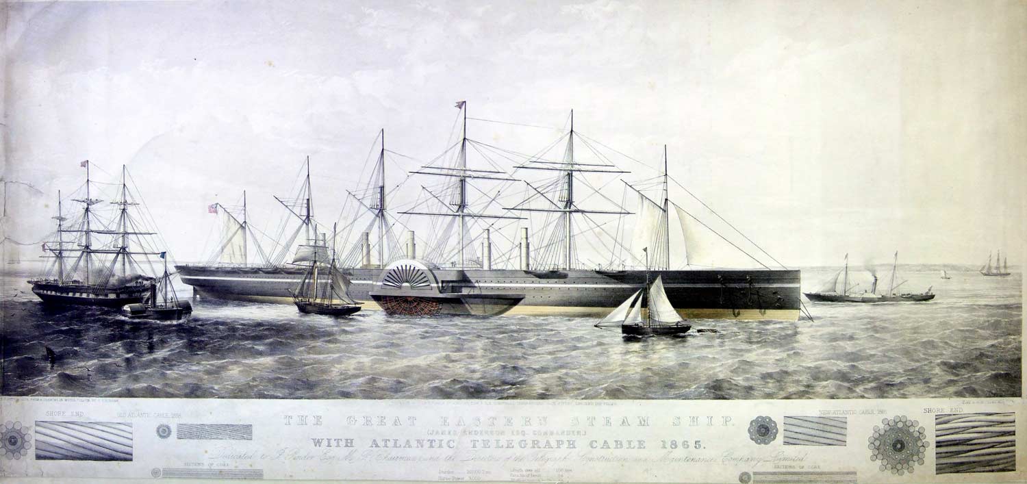
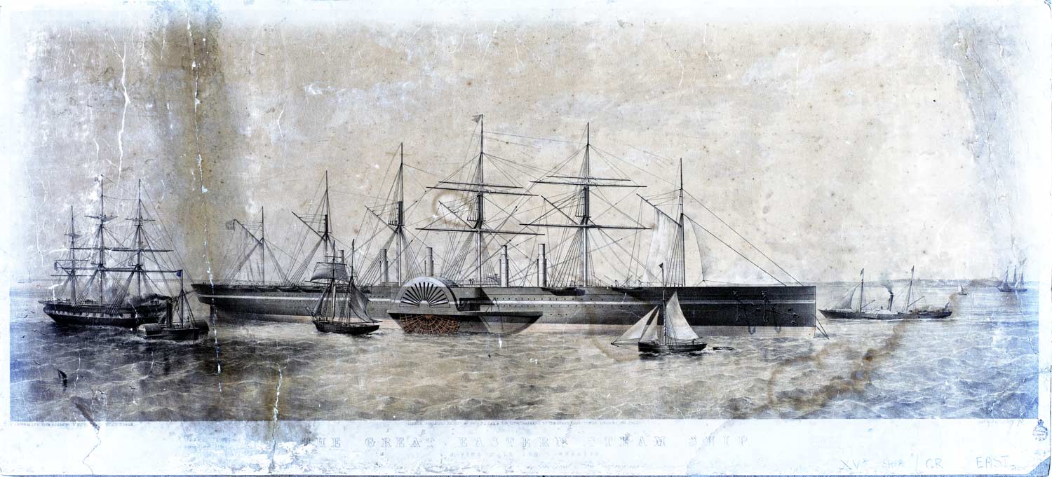
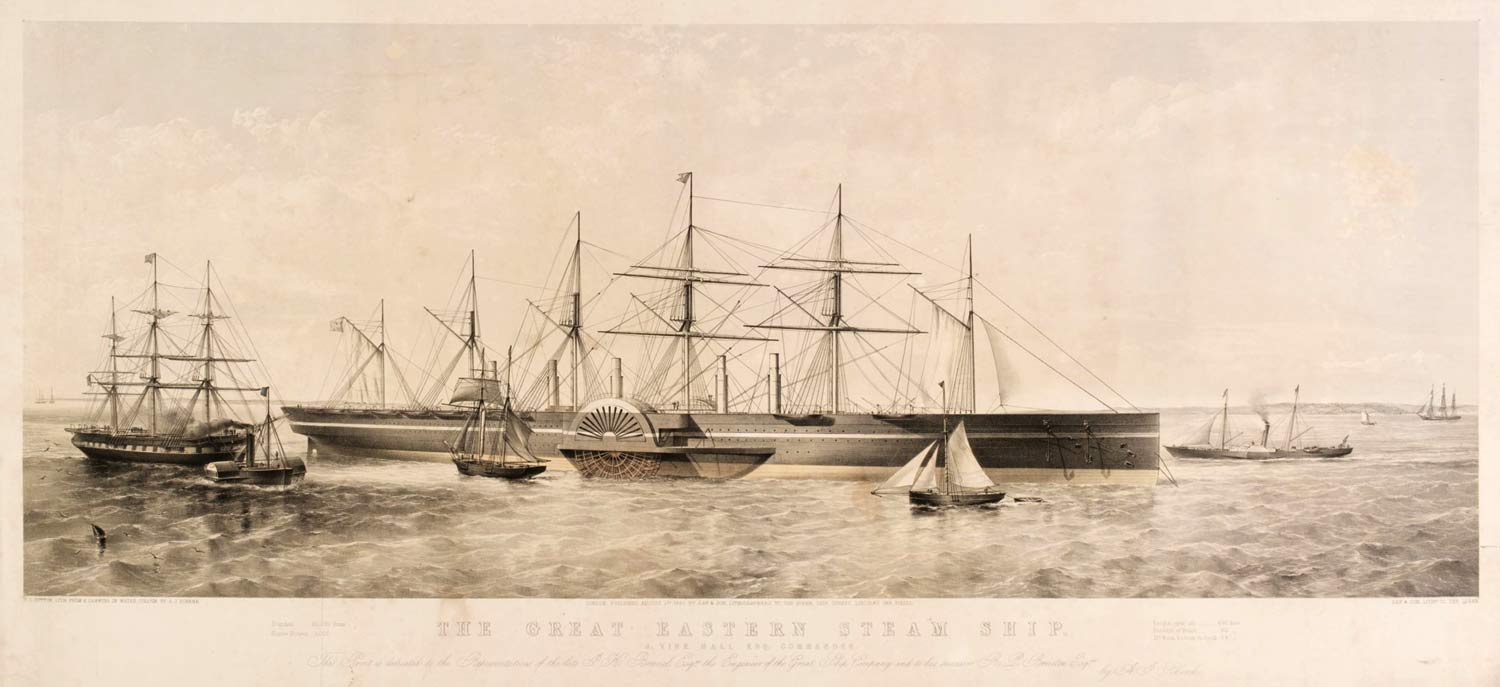
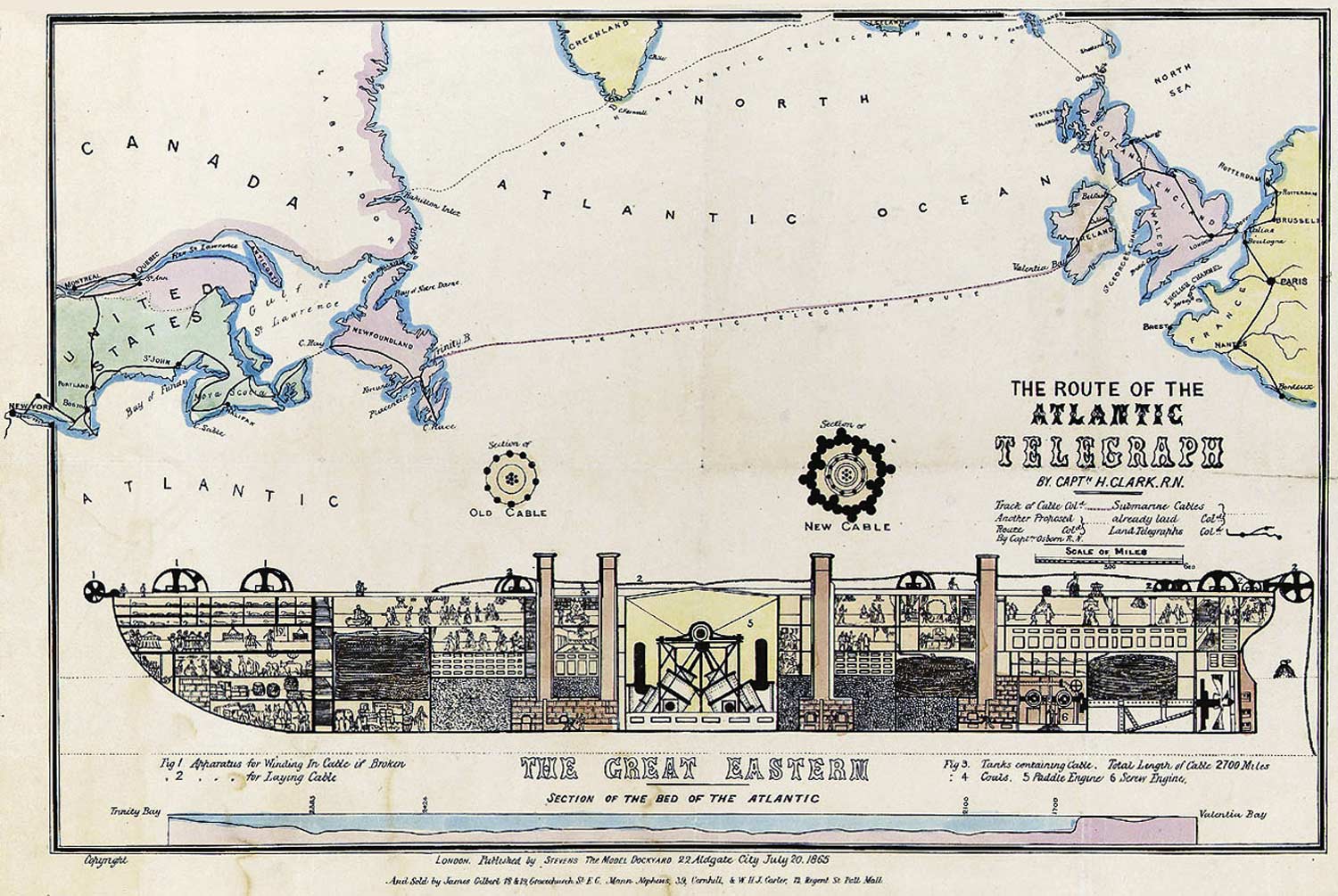
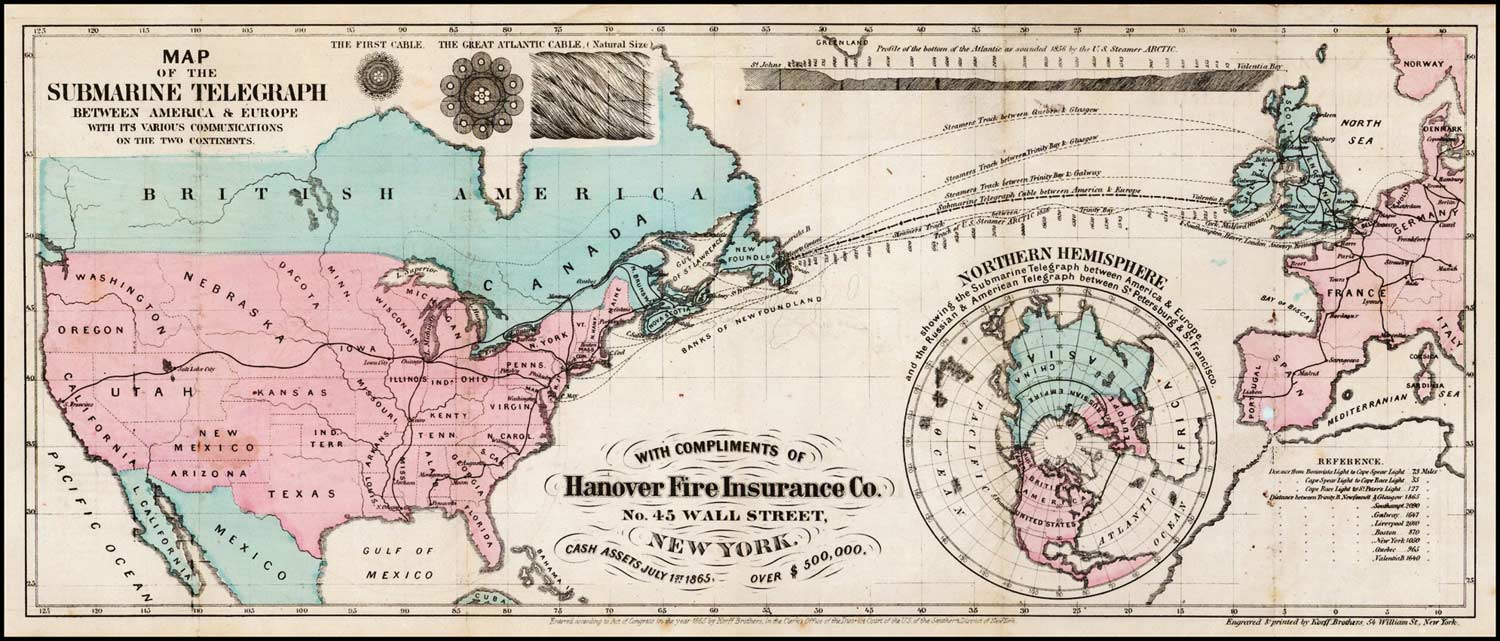


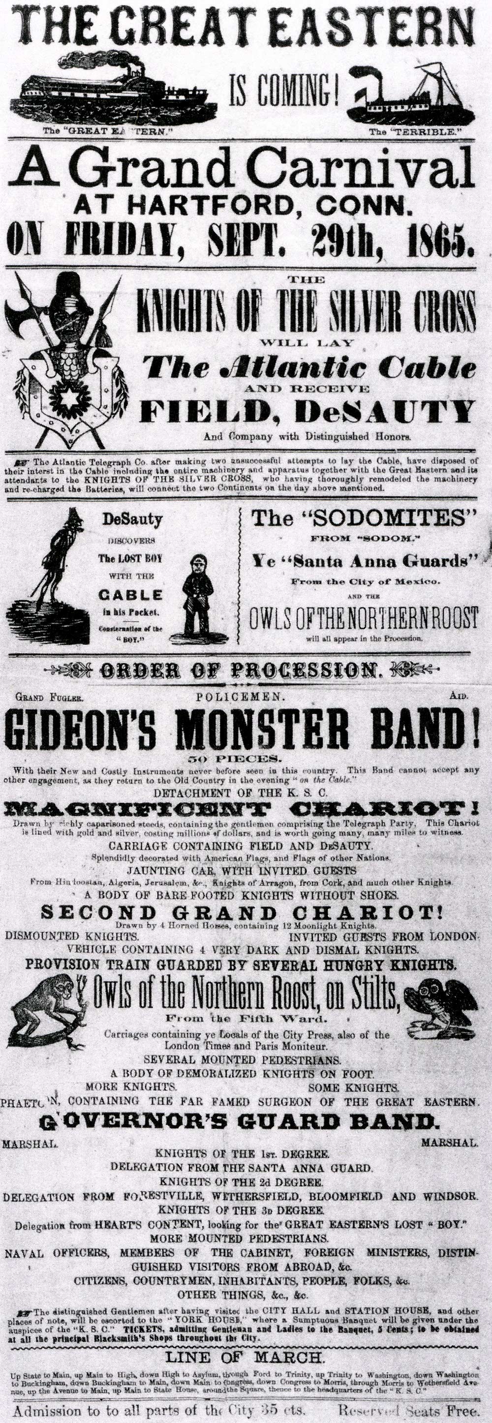
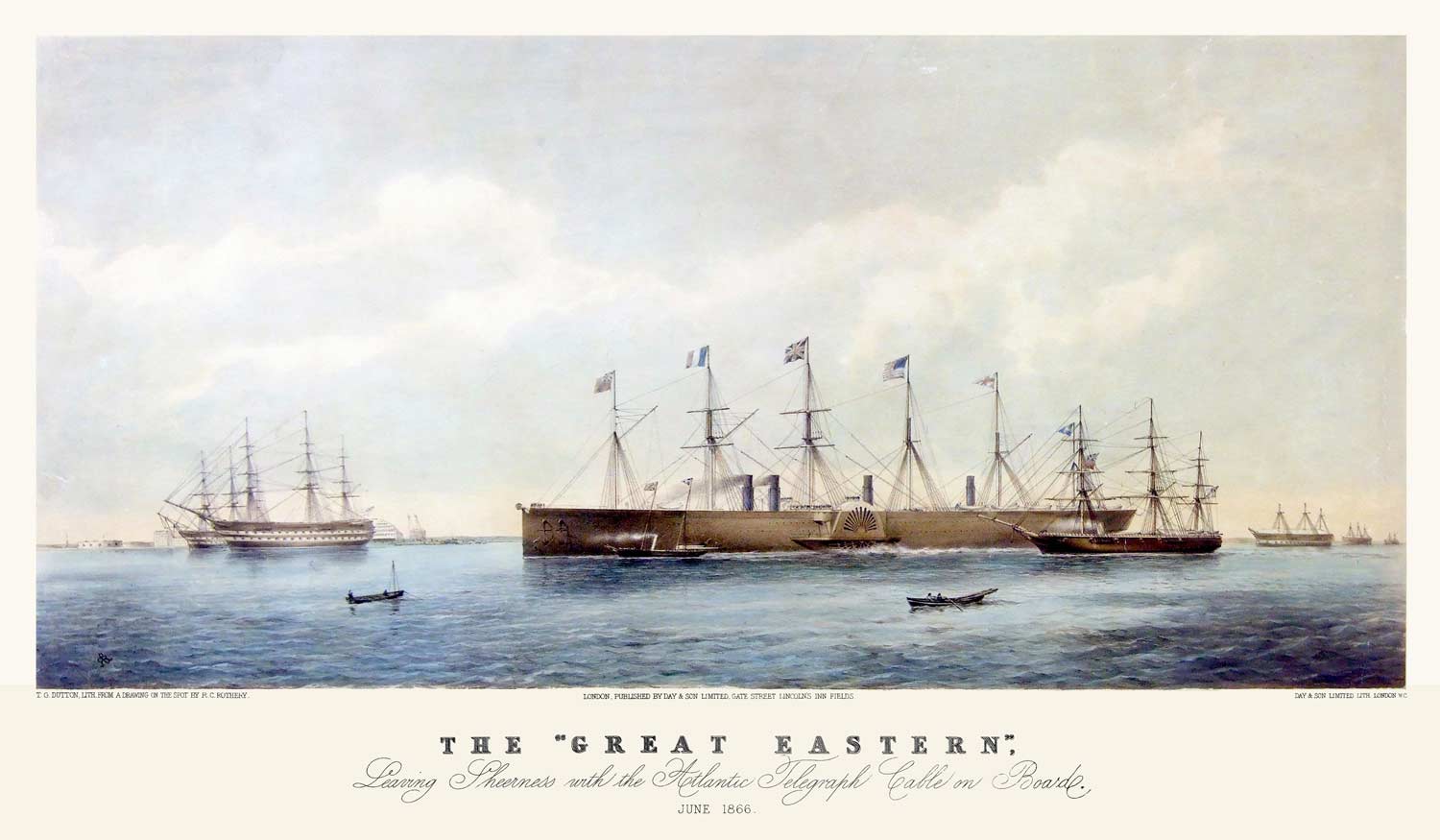
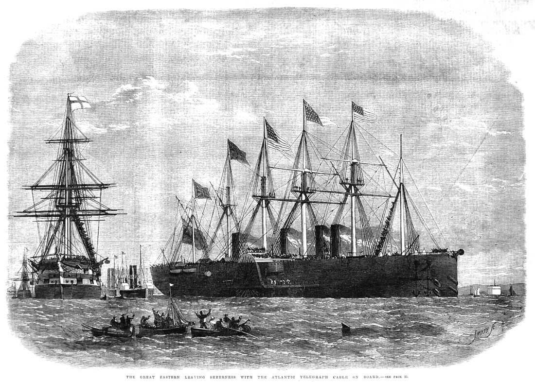
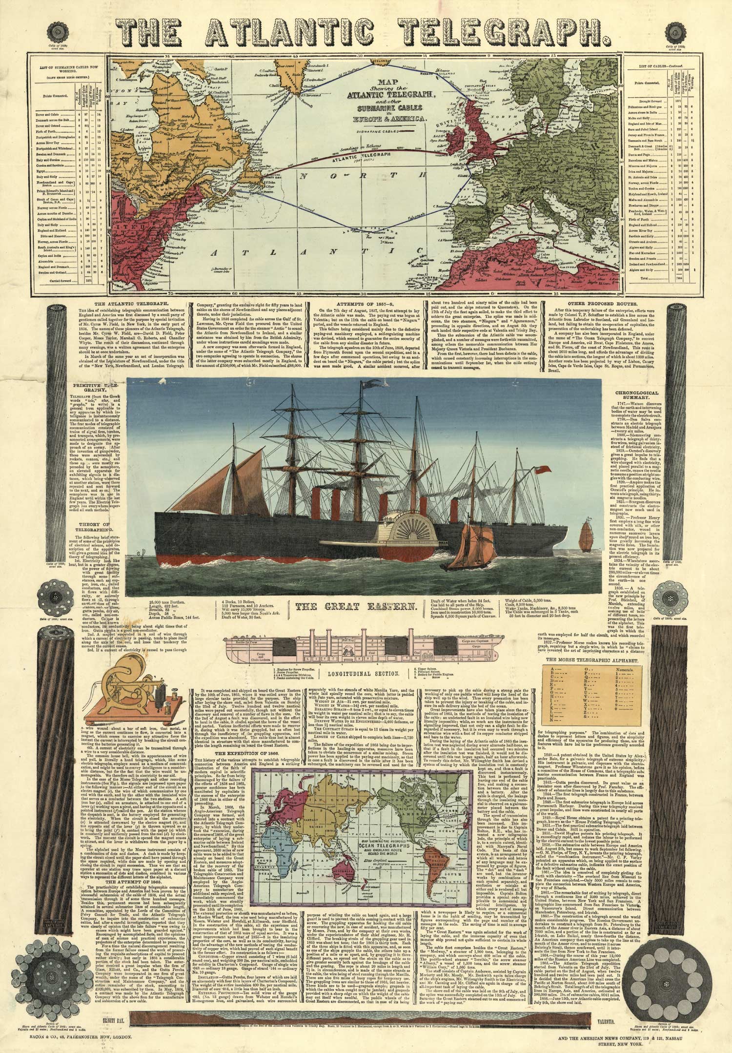


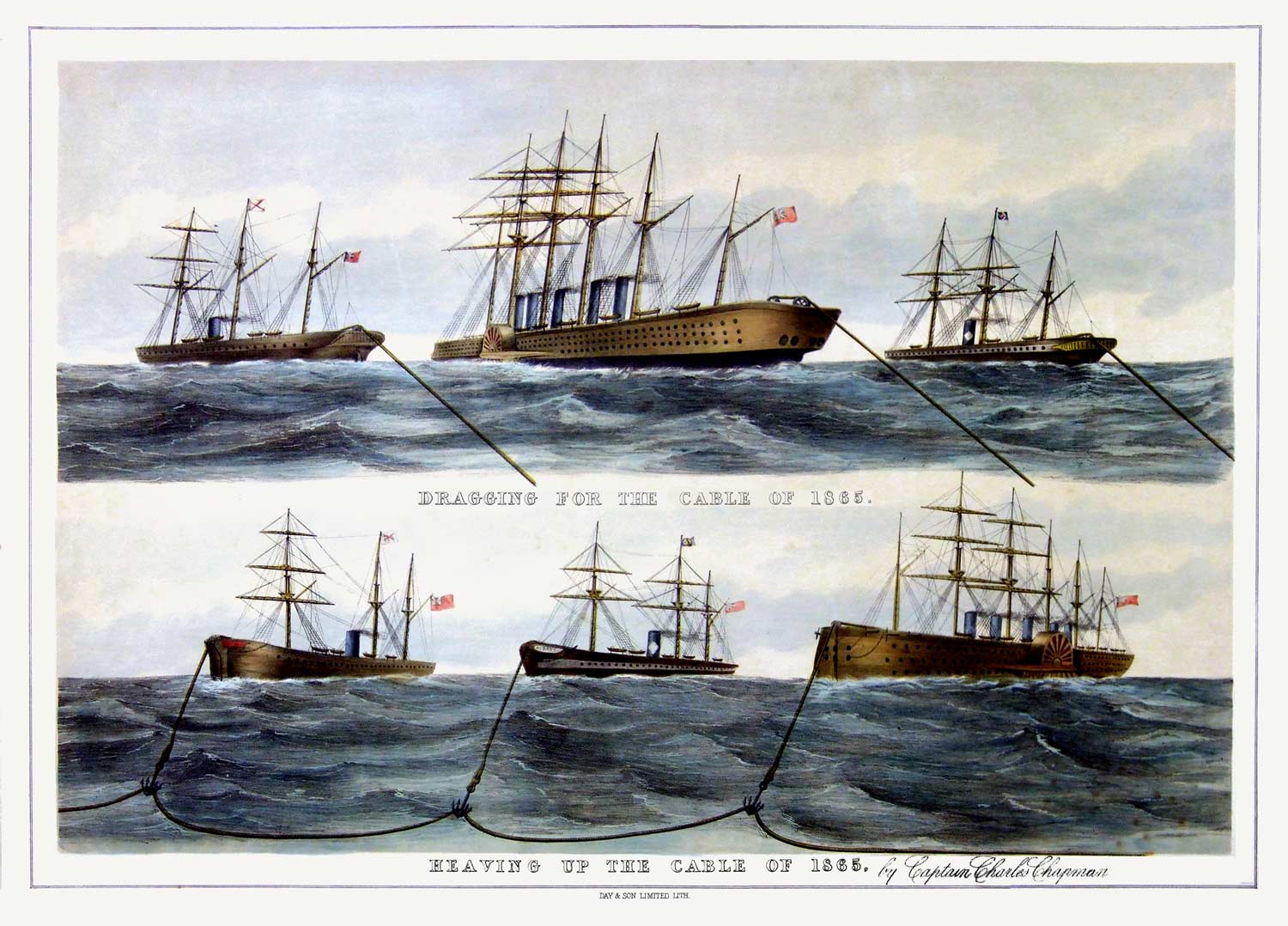
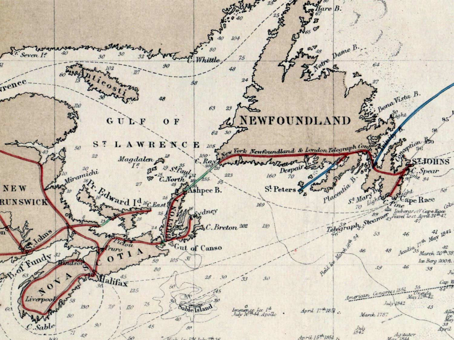
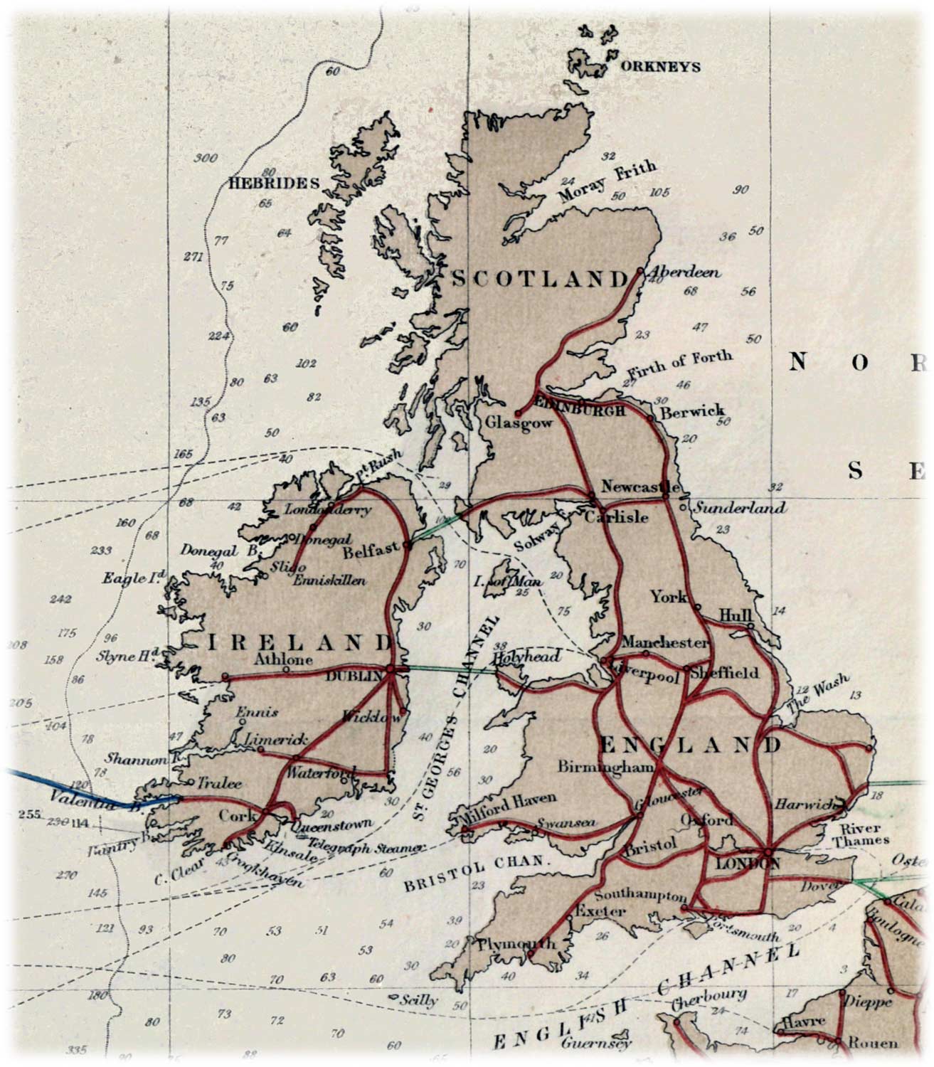
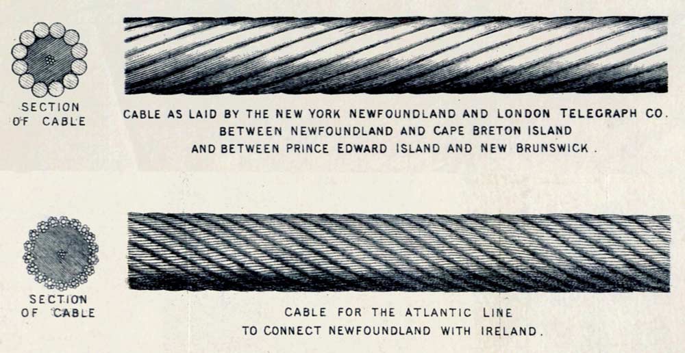
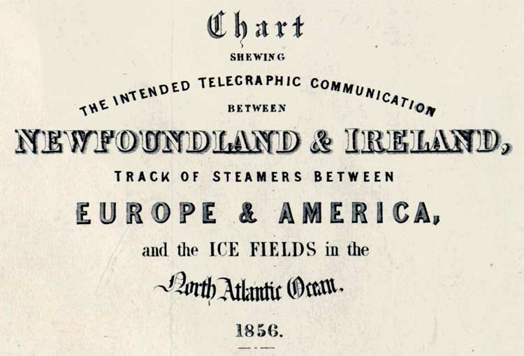
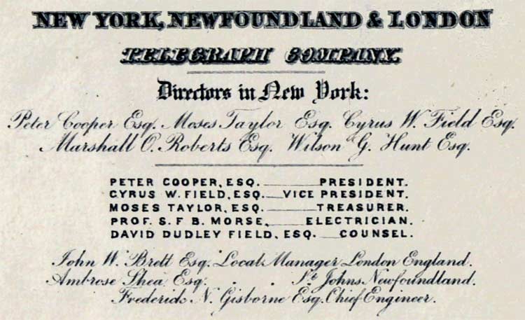
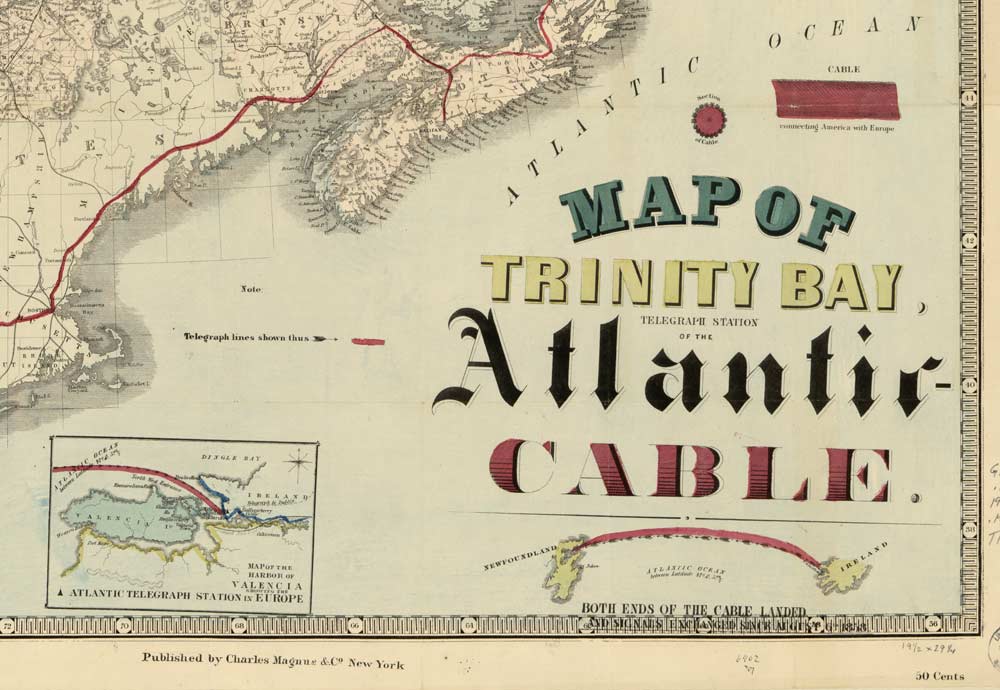
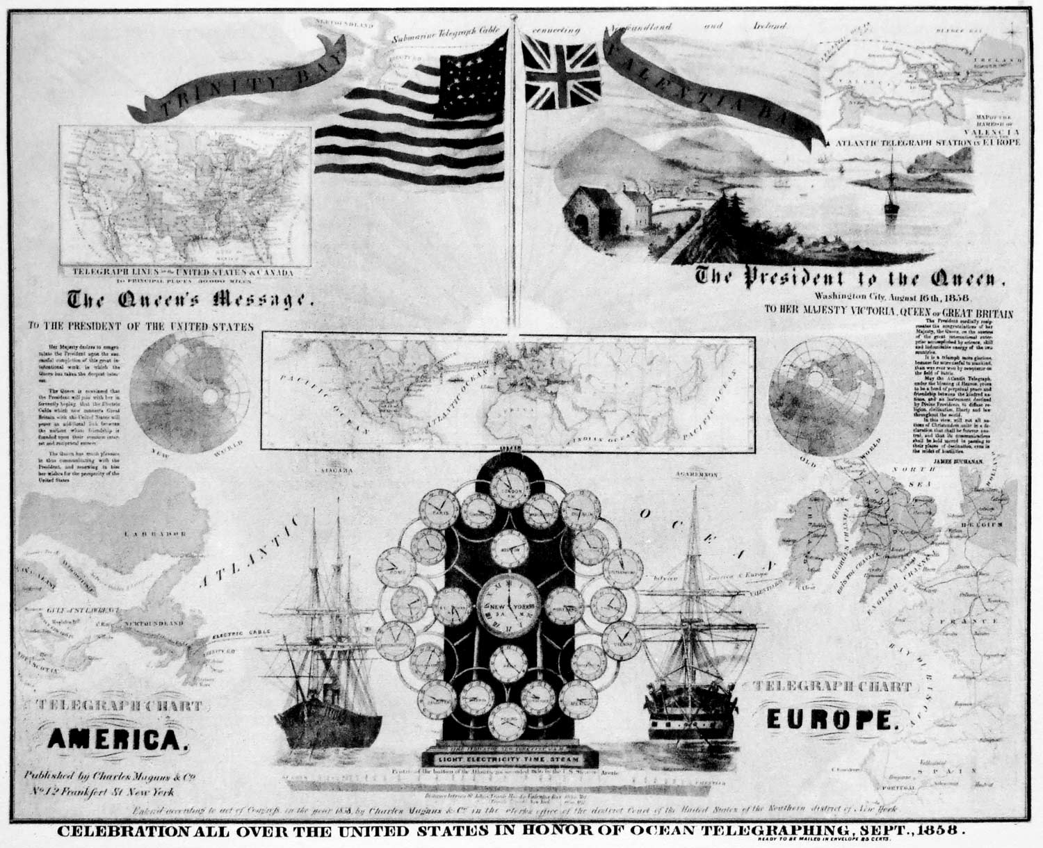
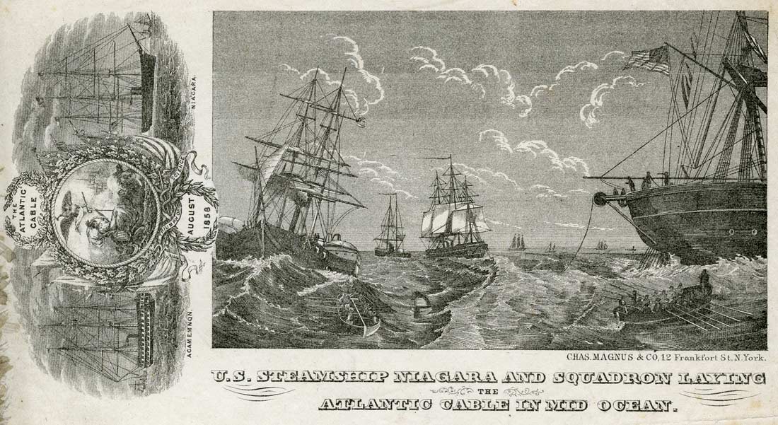
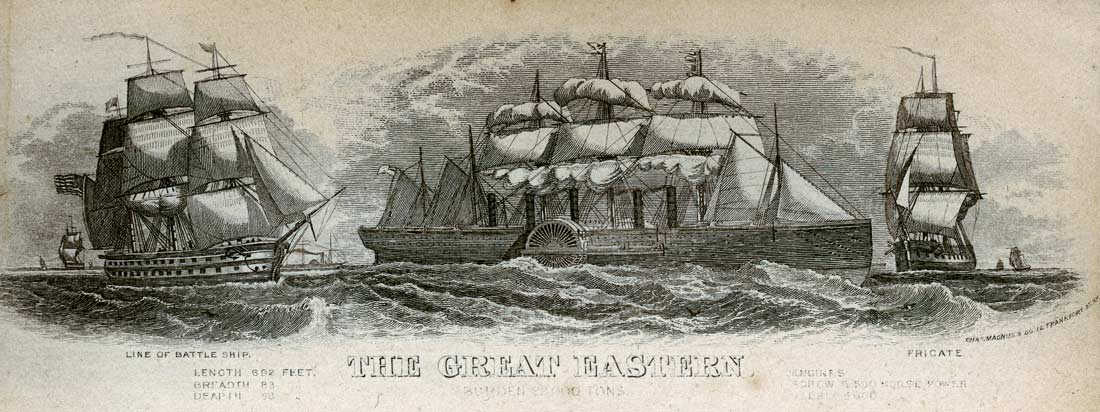
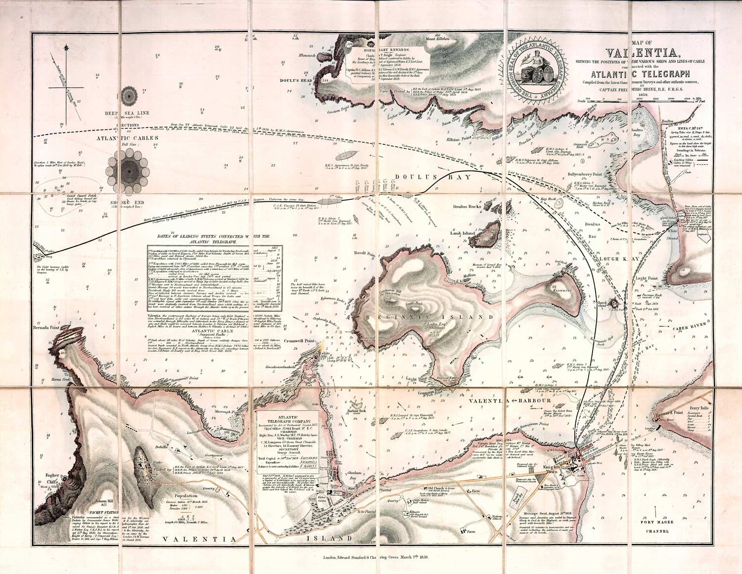